Gulf Breeze, Florida
| Gulf Breeze, Florida | ||
|---|---|---|
| City | ||
|
Entrance sign and median in Gulf Breeze, FL heading East on Hwy 98, July 2013 | ||
| ||
 Location in Santa Rosa County and the state of Florida | ||
| Coordinates: 30°26′36″N 87°12′41″W / 30.44333°N 87.21139°WCoordinates: 30°26′36″N 87°12′41″W / 30.44333°N 87.21139°W | ||
| Country |
| |
| State |
| |
| County | Santa Rosa | |
| Settled | 1875 | |
| Founded (as Gulf Breeze) | 1935 | |
| Incorporated (city) | August 10, 1961 | |
| Government | ||
| • Mayor | Matt Dannheisser Junior | |
| • City Manager | Buz Eddy | |
| Area | ||
| • City | 23.5 sq mi (61.0 km2) | |
| • Land | 4.8 sq mi (12.3 km2) | |
| • Water | 18.8 sq mi (48.7 km2) | |
| Elevation | 16 ft (5 m) | |
| Population (2005) | ||
| • City | 6,455 | |
| • Density | 1,192.0/sq mi (514.88/km2) | |
| • Metro | 461,227 (Pensacola metropolitan area) | |
| Time zone | CST (UTC-6) | |
| • Summer (DST) | CDT (UTC-5) | |
| Area code(s) | 850 | |
| FIPS code | 12-28000[1] | |
| GNIS feature ID | 0283485[2] | |
| Website | http://www.cityofgulfbreeze.com | |


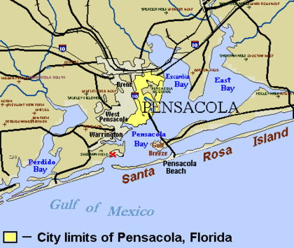
Gulf Breeze is a city on the Fairpoint Peninsula in Santa Rosa County, Florida, United States and is a suburb of Pensacola which lies to the north, across Pensacola Bay. The population was 5,763 at the 2010 census.
Geography and climate
Gulf Breeze is located at 30°21′36″N 87°10′41″W / 30.36000°N 87.17806°W (30.359933, -87.178190).[3]
According to the United States Census Bureau, the city has a total area of 23.5 square miles (61 km2), of which 4.8 square miles (12.3 km²) is land and 18.8 square miles (49 km2) (79.79%) is water.
Growth of the city itself is geographically restricted, surrounded by major water bodies on three sides; the eastern portion of Gulf Breeze is occupied by the Naval Live Oaks Reservation. As a result, new growth takes place east of the city limits along U.S. Highway 98.
| Gulf Breeze, FL | ||||||||||||||||||||||||||||||||||||||||||||||||||||||||||||
|---|---|---|---|---|---|---|---|---|---|---|---|---|---|---|---|---|---|---|---|---|---|---|---|---|---|---|---|---|---|---|---|---|---|---|---|---|---|---|---|---|---|---|---|---|---|---|---|---|---|---|---|---|---|---|---|---|---|---|---|---|
| Climate chart (explanation) | ||||||||||||||||||||||||||||||||||||||||||||||||||||||||||||
| ||||||||||||||||||||||||||||||||||||||||||||||||||||||||||||
| ||||||||||||||||||||||||||||||||||||||||||||||||||||||||||||
Points of interest
In 1828 the U.S. Government purchased the land encompassing the Naval Live Oaks Reservation for experimenting with acorns for the cultivation of live oaks to produce wooden ships. Before the Civil War, Live Oak wood was the primary material of choice for shipbuilders, thus the protection and cultivation of the trees for the US Navy was considered vital for defense in those turbulent times.
Currently, the land comprises over 1300 acres (5.3 km²) in Gulf Islands National Seashore and is supervised by the National Park Service. To the south of Highway 98 is a visitor's center for the Gulf Islands National Seashore and several public beach areas.
Gulf Islands National Seashore offers recreation opportunities and preserves natural and historic resources along the Gulf of Mexico barrier islands of Florida and Mississippi. The protected regions include mainland areas and parts of 7 islands.
The Florida District of the seashore features offshore barrier islands with sparkling white quartz sand beaches (along miles of undeveloped land), historic fortifications, and nature trails.
The Gulf Breeze Zoo is a 50-acre (20 ha) site that includes hundreds of animals, a boardwalk overlooking a free range preserve, CP Huntington style train, as well as other amenities. The zoo features various events throughout the year including Boo at the Zoo and Zoo Lights.[4]
Demographics
| Historical population | |||
|---|---|---|---|
| Census | Pop. | %± | |
| 1970 | 4,190 | — | |
| 1980 | 5,478 | 30.7% | |
| 1990 | 5,530 | 0.9% | |
| 2000 | 5,665 | 2.4% | |
| 2010 | 5,763 | 1.7% | |
| Est. 2015 | 6,323 | [5] | 9.7% |
As of the census[1] of 2000, there were 5,665 people, 2,377 households, and 1,678 families residing in the city. The population density was 1,192.0 people per square mile (460.5/km²). There were 2,553 housing units at an average density of 537.2 per square mile (207.5/km²).
There were 2,377 households out of which 28.1% had children under the age of 18 living with them, 57.7% were married couples living together, 10.6% had a female householder with no husband present, and 29.4% were non-families. 25.3% of all households were made up of individuals and 13.0% had someone living alone who was 65 years of age or older. The average household size was 2.36 and the average family size was 2.83.
In the city the population was spread out with 22.3% under the age of 18, 4.6% from 18 to 24, 22.5% from 25 to 44, 29.7% from 45 to 64, and 20.8% who were 65 years of age or older. The median age was 45 years. For every 100 females there were 89.4 males. For every 100 females age 18 and over, there were 83.6 males.
The median income for a household in the city was $52,522, and the median income for a family was $61,661. Males had a median income of $44,408 versus $28,159 for females. The per capita income for the city was $34,688. About 3.8% of families and 4.2% of the population were below the poverty line, including 5.5% of those under age 18 and 1.2% of those age 65 or over.
Public transportation
Gulf Breeze is served by Escambia County Area Transit's #61 route.[7][8]
Schools

- Gulf Breeze High School (website)
- Gulf Breeze Middle School
- Gulf Breeze Elementary School (website)
- Oriole Beach Elementary School
Notable people
- Doug Baldwin, American football player.
- Adrian Street, professional wrestler (longtime resident).
- Bob Armstrong, professional wrestler (originally from Marietta, Georgia; longtime resident).
- Abigail Spencer, actress; born and raised in Gulf Breeze.[9]
- Jason McKie, American football player.
See also
References
- 1 2 "American FactFinder". United States Census Bureau. Retrieved 2008-01-31.
- ↑ "US Board on Geographic Names". United States Geological Survey. 2007-10-25. Retrieved 2008-01-31.
- ↑ "US Gazetteer files: 2010, 2000, and 1990". United States Census Bureau. 2011-02-12. Retrieved 2011-04-23.
- ↑ "Gulf Breeze Zoo". Retrieved 2011-11-22.
- ↑ "Annual Estimates of the Resident Population for Incorporated Places: April 1, 2010 to July 1, 2015". Retrieved July 2, 2016.
- ↑ "Census of Population and Housing". Census.gov. Retrieved June 4, 2015.
- ↑ http://www.goecat.com/routes/_doc/ride-guide.pdf
- ↑ http://www.goecat.com/routes/index.php
- ↑ http://www.buddytv.com/info/abigail-spencer-info.aspx
External links
- The Gulf Breeze Zoo — the regional zoo.
- Gulf Breeze Area Chamber of Commerce — the area's chamber of commerce
| Counties | 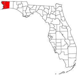 | |
|---|---|---|
| Major city | ||
| Incorporated Cities | ||
| Unincorporated | ||
Municipalities and communities of Santa Rosa County, Florida, United States | ||
|---|---|---|
| Cities |  | |
| Town | ||
| CDPs |
| |
| Unincorporated communities |
| |