Guldara
| Guldara | |
|---|---|
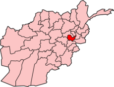
 Guldara Location in Afghanistan | |
| Coordinates: 34°49′1″N 69°5′16″E / 34.81694°N 69.08778°ECoordinates: 34°49′1″N 69°5′16″E / 34.81694°N 69.08778°E | |
| Country |
|
| Province | Kabul Province |
| District | Guldara District |
| Elevation | 5,650 ft (1,722 m) |
| Time zone | UTC+4:30 |
Guldara (also Gūḏāra, Gudara, or Gowdārah) is a village and the center of Guldara District, Kabul Province, Afghanistan. It is located at 34°49′02″N 69°05′16″E / 34.8172°N 69.0878°E at 1722 m altitude, 45 km North of Kabul. The village was almost fully destroyed and now is continuing the process of rehabilitation. A new clinic has been opened. A local NGO, Afghan Educational and Rehabilitation Organisation (AERO) is running this clinic which will provide family planning, child and general health services to a population of around 38,000 people.
This article is issued from Wikipedia - version of the 9/22/2013. The text is available under the Creative Commons Attribution/Share Alike but additional terms may apply for the media files.