Guillaume Brouscon
._HM_46._PORTOLAN_ATLAS_and_NAUTICAL_ALMANAC._France%2C_1543.jpg)
A world map by Guillaume Brouscon, an example of a Dieppe map, 1543.
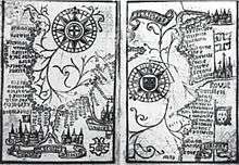
Brouscon's Almanach of 1546: Compass bearing of high waters in the Bay of Biscay (left) and the coast from Brittany to Dover (right).
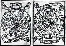
Brouscon's Almanach of 1546: Tidal diagrams "according to the age of the Moon".
Guillaume Brouscon was a Breton cartographer of the Dieppe school in the 16th century.[1] He was from the port of Le Conquet, near Brest,[2] which is shown prominently in large red lettering on his 1543 map of the world.
He published his Brouscon's Almanachs in 1546, which were used for their information on tides by English, French and Breton sailors. They allowed to known the direction of tidal currents, and to calculate tide level depending on the phase of the moon.[2]
Notes
- ↑ Roger Hervé, Le pilote et cartographe Guillaume Brouscon, du Conquet vers 1540-1550, 1984; Hubert Michéa, Les cartographes du Conquet et le début de l'imprimerie. Guillaume Brouscon, une vie pleine de mystère, Société archéologique du Finistère, 1986; Hubert Michea “Le cartographe conquetois Guillaume Brouscon et la géopolitique: 1543-1548”, Comité des Travaux Historiques et Scientifiques, Section d'Histoire des Sciences et des Techniques, Lyon, Cité de Savants, Paris, Editions du CTHS, 1988.
- 1 2 Tides: a scientific history David Edgar Cartwright p.18
This article is issued from Wikipedia - version of the 10/11/2016. The text is available under the Creative Commons Attribution/Share Alike but additional terms may apply for the media files.