Gugark
| Գուգարք | |||||
| Province of Greater Armenia | |||||
| |||||
 | |||||
| {{#if:Ardahan| | Capital | Ardahan | |||
| History | |||||
| • | Artaxias I declaring himself independent | 189 BC | |||
| • | Disestablished | 13th century | |||
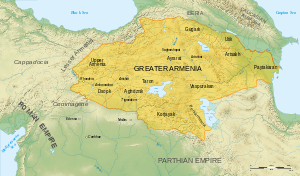
Gugark (Armenian: Գուգարք, Georgian: გოგარენე, Latin: Gogarene) was the 13th province of Greater Armenia. It now comprises parts of northern Armenia, northeast Turkey, and southwest Georgia.[1]
History
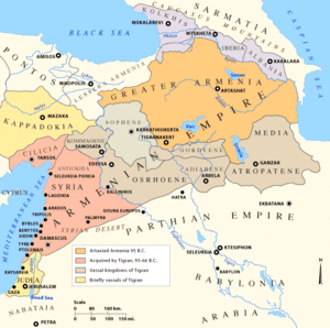
At first, Gugark was part of Urartu. ; from the 6th century, it became part of Satrapy of Armenia. In III century the territory was conquered by Caucasian Iberia, but during Artaxias I's reign it was re-united. During the reign of the Artaxiad and Arshakuni kings of Armenia, Gugark served as one of the kingdom's four bdeshkhs, responsible for protecting the state's northern border. In the course of the 4th century, the region was ruled by members of the House of Mihran.[2] In 387, Armenia was partitioned between the Byzantine and Sassanid empires and Gugark, with the exception of the canton of Tashir, was a made part of Caucasian Iberia. The ruler of the region around 425 was Archoucha (Arshusha of Gogarene). In 652, the Armenian prince Theodore Rshtuni was allowed by the Arabs to unite Gugark with his realms.
In the following centuries, Gugark and its cantons fell under the sway of several rulers. In the 8th century, it became a part of Emirate of Tbilisi; in the middle of the 9th century, it was taken by the Georgian Bagrationis, while the Armenian Bagratunis took over its eastern cantons.[3]
Inhabitants
Armenian catholicos Hovhannes Draskhanakerttsi says in his books that the majority of this region was non-Armenian people, related to caucasian Iberians.Also an Armenian historian Ghazar Parpetsi mentions Arshusha V pitiakhsh of Gugars, as pitiakhsh of Georgians. These facts prove the statement that this region had been populated by Georgian tribe called Gugars.
See also
References
- ↑ Armenian Soviet Encyclopedia
- ↑ Toumanoff, Cyril. Introduction to Christian Caucasian History, II: States and Dynasties of the Formative Period. Traditio 17 (1961), p. 38.
- ↑ Armenian Soviet Encyclopedia
Historical states and regions of Armenia | ||
|---|---|---|
| Independent Armenian states |
|  |
| Minor or dependent Armenian states |
| |
| Provinces or Ashkhars of Armenia Major | ||
| Other Armenian regions |
| |
| Other provinces under Tigranes the Great | ||
Coordinates: 41°04′00″N 44°26′00″E / 41.0667°N 44.4333°E