Guardalavaca
| Guardalavaca | |
|---|---|
| Village | |
|
Beach at Guardalavaca | |
 Location of Guardalavaca in Cuba | |
| Coordinates: 21°07′30″N 75°49′44″W / 21.12500°N 75.82889°WCoordinates: 21°07′30″N 75°49′44″W / 21.12500°N 75.82889°W | |
| Country |
|
| Province | Holguín |
| Municipality | Banes |
| Elevation | 5 m (16 ft) |
| Time zone | EST (UTC-5) |
| Area code(s) | +53-24 |
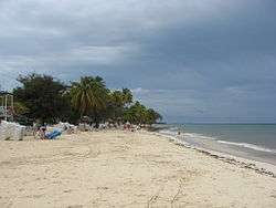
Guardalavaca is a town in the Holguín Province of Cuba. It is a tourist location due to its white sandy beaches and warm waters.
Geography
It is located on the northern shore of Cuba, bordering Bahia de Naranjo (Orange Bay), on Cabo Lucrecia, and is part of the municipality of Banes. Beaches in Guardalavaca include Guardalavaca Beach, Playa Esmeralda, Don Lino and Bahia de Naranjo.
History
Naming
"Guardalavaca" literally means "guard the cow" in Spanish. There are several accounts as to how this name may have originated; one version maintains that Guardalavaca is a malapropism for its original name Guardalabarca, meaning "guard the ship". The area was once heavily targeted by sea pirates, and Bahía de Naranjo[1] near what is now the town of Guardalavaca is a secluded shallow bay connected to the open sea by a narrow inlet, which made it a proper safe haven to guard ships against pirates. On the other hand, the name may have originated from pirates going after the cattle grazing in the area. As pirates were spotted, the local farmers would thus shout, "Guardalavaca" - guard the cow.
The Cuban government has attempted on several occasions to change the name of the area as they deem it not to be very appealing; they have so far been unsuccessful.
References
External links
![]() Media related to Guardalavaca at Wikimedia Commons
Media related to Guardalavaca at Wikimedia Commons