Guajira Peninsula

Guajira Peninsula (Spanish: Peninsula de La Guajira, also spelled Goajira, mainly in colonial period texts), is a peninsula in northern Colombia and northwestern Venezuela in the Caribbean. It is the northernmost peninsula in South America and has an area of 25,000 km2 (9,700 sq mi) extending from the Manaure Bay (Colombia) to the Calabozo Ensenada in the Gulf of Venezuela (Venezuela), and from the Caribbean to the Serranía del Perijá mountains range. It was the subject of a dispute between Venezuela and Colombia in 1891, and on arbitration was awarded to the latter and joined to its Magdalena Department. Nowadays, most of the territory is part of Colombia, making it part of La Guajira Department, while the remaining strip pertains to the Venezuelan Zulia State. The northernmost part of the peninsula is called Punta Gallinas (12° 28´ N) and is also considered the northernmost part of mainland South America.[1]
Climate
The scenery of Guajira is very picturesque; the temperature in the plains is very high, but temperate in the mountains.
The region receives the flow of the trade winds from the northern hemisphere and forms along the northeastern coast of Venezuela and the Antilles, the Guajira-Barranquilla xeric scrub. The Trade winds cause a resurgence of the deep littoral waters and makes the sea more rich in living species on the western side of the peninsula. The northeastern flank of the Sierra Nevada de Santa Marta mountain range acts as a barrier that generates abundant rainfall in its steppes and originate the Ranchería River, the only major river in the area. Climate and vegetation varies from south to north, presenting a hyper humid jungle weather in the southern part (3000 mm a year) to the desertic areas in the north (300 mm a year).
In the northern area there is a small range of mountains called Macuira that reaches 900 m over sea level that trap some of the trade winds and cause mist. Most of the mountain range is a protected area called National Natural Park of Macuira. Nearby there is also the 80 km² Flamingos Fauna and Flora Sanctuary.
Economy
The peninsula is mainly inhabited by members of the native tribe of the Wayuus which use the plains to raise cattle, sheep, goats and horses. The descendants of the Spanish colonists settled in the southeastern part of the peninsula (sometimes referred to as the Padilla Province), where the land is more fertile due to the proximity to other river basins, such as the Cesar river basin and is subject to large plantations of cotton, sorghum and cattle ranching.
Since the 1980s the central area of the peninsula was subject to the exploration and exploitation of coal and natural gas in the area of Cerrejón and of oil in the littoral. A popular ecotourism destination in the area is Cabo de la Vela
Missionary history
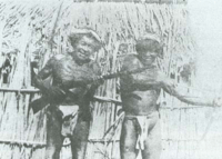
The mission of Goajira was erected by Pope Pius X on 17 January 1905, into a vicariate Apostolic, dependent on the Congregation for Extraordinary Ecclesiastical Affairs. Mgr Attanasio Maria Vincenzo Soler-Royo, O.F.M. Cap., was appointed to the vicariate, as titular Bishop of Citharizum, on 18 April 1907. The early 20th century missionaries described the inhabitants of the area as "tall and well made. Formerly they were very intractable, but the Capuchins, who were in charge of the Catholic missions, have had a great influence over them, and large numbers have been converted. The chief towns are Paraguaipoa, Calabacito, Maricha, Marocaso and Soldado."[2] Today, the Catholic education is no longer mandatory for the indigenous people, who are allowed to educate their children in the Wayuu traditions and language (Wayuunaiki).
In Papillon, Henri Charrière writes: "The Goajira Indians are seafarers who fish for pearls. Their primary diet is said to consist of fish, turtle meat, turtle eggs and big green lizards, most likely Iguanas. Men and women are dressed only in a loincloth which covers their crotch."[3]
See also
- Distocyclus goajira, an electric fish
- T-63 Goajira, a ship of the navy of Venezuela
- Guajira Department, Guajira-Barranquilla xeric scrub and La Guajira Desert
References
- ↑ USGS: Caribbean Coast: Guajira Peninsula coast USGS Accessed 24 August 2007.
- ↑
 This article incorporates text from a publication now in the public domain: Herbermann, Charles, ed. (1913). "article name needed". Catholic Encyclopedia. New York: Robert Appleton.
 - ↑ Charrière, Henri (January 1970). Papillon. London, UK: Hart-Davis Macgibbon Ltd. pp. ?. ISBN 0-246-63987-3.
Further reading
- (Spanish) Henri Candelier. 1892. Riohacha y los Indios Guajiros. Crónica de un viajero y explorador francés quien durante tres años, 1889–1892, recorrió La Guajira.
- (Spanish) Martha Ligia Castellanos, Luis Carlos Pardo L. 2000. Caracterización y primera aproximación a la determinación del índice de biodiversidad en los suelos de la cuenca del arroyo Mekijanao, Serranía de la Macuira, Alta Guajira. En: Juan Carlos Pérez (editor) X Congreso Nacional de la Ciencia del Suelo. Programa y resúmenes. El suelo un componente del medio natural. Medellín, Octubre 11 al 13 de 2000
- (Spanish) Edith González, Gabriel Guillot, Néstor Miranda, Diana Pombo (editores). 1990. Perfil Ambiental de Colombia. Colciencias. Escala. Bogotá.
- (Spanish) Instituto Geográfico Agustín Codazzi. 1996. Diccionario Geográfico de Colombia. Edición en CD-ROM. Bogotá, Colombia.
- Thomas Stadtmüller. 1987. Cloud Forests in the Humid Tropics. A Bibliographic Review. The United Nations University, Centro Agronómico Tropical de Investigación y Enseñanza. Turrialba, Costa Rica. 82 pp.
Treasures of Colombia | |||||||||||||||||||||||||||||||||||||||||||||||||||||
|---|---|---|---|---|---|---|---|---|---|---|---|---|---|---|---|---|---|---|---|---|---|---|---|---|---|---|---|---|---|---|---|---|---|---|---|---|---|---|---|---|---|---|---|---|---|---|---|---|---|---|---|---|---|
Archaeological sites · Colombia magia salvaje · National monuments · National parks · World Heritage sites | |||||||||||||||||||||||||||||||||||||||||||||||||||||
| |||||||||||||||||||||||||||||||||||||||||||||||||||||
| |||||||||||||||||||||||||||||||||||||||||||||||||||||
| |||||||||||||||||||||||||||||||||||||||||||||||||||||
Source: Wills, Fernando et al. 2001. Nuestro patrimonio - 100 tesoros de Colombia - Our heritage - 100 treasures of Colombia, 1-311. El Tiempo. | |||||||||||||||||||||||||||||||||||||||||||||||||||||
Coordinates: 12°00′00″N 71°30′00″W / 12.000°N 71.500°W