Guadalquivir
| Guadalquivir | |
| River | |
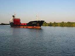 Guadalquivir River near Coria del Río Seville | |
| Name origin: from al-wadi al-kabir, "great valley" or "big wash" in Arabic | |
| Country | Spain |
|---|---|
| Region | Andalusia |
| Tributaries | |
| - left | Guadiana Menor, Guadalbullón, Guadajoz, Genil, Corbones, Guadaira |
| - right | Guadalimar, Jándula, Yeguas, Guadalmellato, Guadiato, Bembézar, Viar, Rivera de Huelva, Guadiamar |
| Cities | Córdoba, Seville |
| Source | Cañada de las Fuentes |
| - location | Cazorla Range, Quesada, Jaén |
| Mouth | Atlantic Ocean |
| - location | Sanlúcar de Barrameda, Cádiz |
| - elevation | 0 m (0 ft) |
| - coordinates | ES 36°47′N 6°21′W / 36.783°N 6.350°WCoordinates: ES 36°47′N 6°21′W / 36.783°N 6.350°W |
| Length | 657 km (408 mi) |
| Basin | 56,978 km2 (21,999 sq mi) |
| Discharge | for Seville |
| - average | 164.3 m3/s (5,802 cu ft/s) |
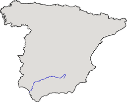 Location of the Guadalquivir | |
| Website: Confederación Hidrográfica del Guadalquivir | |
The Guadalquivir (Spanish pronunciation: [ɡwaðalkiˈβir]) is the fifth longest river in the Iberian peninsula and the second longest river with its entire length in Spain.
The Guadalquivir river is the only great navigable river in Spain. Currently it is navigable to Seville, but in Roman times it was navigable to Córdoba.
Geography
The Guadalquivir is 657 kilometers, (408 miles) long and drains an area of about 58,000 square kilometers. It begins at Cañada de las Fuentes (village of Quesada) in the Cazorla mountain range (Jaén), passes through Córdoba and Seville and ends at the fishing village of Bonanza, in Sanlúcar de Barrameda, flowing into the Gulf of Cádiz, in the Atlantic Ocean.
The marshy lowlands at the river's end are known as "Las Marismas". The river borders Doñana National Park reserve.
Name
The modern name of Guadalquivir comes from the Arabic al-wādi al-kabīr (الوادي الكبير), 'great valley'. Classical Arabic Wadi is pronounced in present-day Maghrebi Arabic as Oued.
There were a variety of names for the Guadalquivir in Classical and pre-Classical times. Baetis was its name to the Romans, and Greek geographers sometimes called it the river of Tartessus. Before Phoenician, Greek, and Roman colonists arrived, two indigenous names for the river may have been Kertis/Certis and Rérkēs (Ρέρκης).[1]
History
The Phoenicians established the first anchorage grounds and dealt in precious metals. The ancient city of Tartessos was said to have been located at the mouth of the Guadalquivir, although its site has not yet been found.
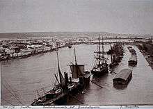
The Romans, whose name for the river was Betis Baetis, settled in Hispalis (Seville), in the 2nd century BC, making it into an important river port. By the 1st century BC Hispalis was a walled city with shipyards building longboats to carry wheat. In the 1st century AD the Hispalis was home to entire naval squadrons. Ships sailed to Rome with various products: minerals, salt, fish, etc. During Arab rule between 712 and 1248, the Moors left a stone dock and the Torre del Oro (Tower of Gold), to reinforce the port defences.
In the 13th century, Ferdinand III expanded the shipyards and from Seville's busy port, grain, oil, wine, wool, leather, cheese, honey, wax, nuts and dried fruit, salted fish, metal, silk, linen and dye were exported throughout Europe.
A reconstructed waterwheel is located at Cordoba on the Guadalquivir River. The Molino de la Albolafia waterwheel originally built by the Romans provided water for the nearby Alcazar gardens as well as being used to mill flour.[2]
After the discovery of the Americas, Seville became the economic centre of the Spanish Empire as its port monopolised the trans-oceanic trade and the Casa de Contratación (House of Trade) wielded its power. As navigation of the Guadalquivir River became increasingly difficult Seville's trade monopoly was transferred to Cádiz.The construction of the artificial canal known as the Corta de Merlina in 1794 marked the beginning of the modernisation of the port of Seville.
In late November 2010 the new Seville lock began to function as a regulator of the tides to finish five years of work (2005-2010).
Flooding
The Guadalquivir River Basin occupies an area of 63,085 km2 and has a long history of severe flooding.
During the winter of 2010 heavy rainfall caused severe flooding in rural and agricultural areas in the provinces of Seville, Cordoba and Jaen in the Andalusia region. The accumulated rainfall in the month of February was above 250 liters per m2, double the precipitation for Spain for that month. In March 2010 several tributaries of the Guadalquivir flooded, causing over 1,500 people to flee their homes as a result of increased flow of the Guadalquivir River, which on 6 March 2010 reached a volume of 2000 m3/s in Cordoba and 2700 m3/s in Seville. This was below that recorded in Seville in the flood of 1963 when a volume of 6000 m3/s. was reached. During August 2010 when flooding occurred in Jaen, Cordoba and Seville three people died in Cordoba as a result.[3]
Pollution
The Doñana disaster, also known as the Aznalcollar Disaster or Guadiamar Disaster was an industrial accident in Andalusia. In April 1998 a holding dam burst at the Los Frailes mine, near Aznalcóllar, Seville Province, releasing 4–5 million cubic metres of mine tailings. The Doñana National Park was also affected by this event.
Dams and bridges

Of the numerous bridges spanning the Guadalquivir, one of the oldest is the Roman bridge of Córdoba. Significant bridges at Seville include the Puente del Alamillo (1992), Puente de Isabel II or Puente de Triana (1852), and Puente del V Centenario (1972).
The El Tranco de Beas Dam at the head of the river was built between 1929 and 1944 as a hydroelectricity project of the Franco regime. Doña Aldonza Dam is located in the Guadalquivir riverbed, in the Andalusian municipalities of Ubeda, Peal de Becerro and Torreperogil in the province of Jaen.
Ports
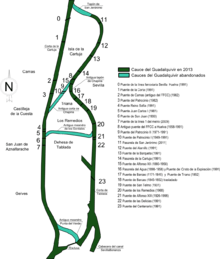
The Port of Seville (es) is the primary port on the Guadalquivir River. The Port Authority of Seville is responsible for developing, managing, operating, and marketing the Port of Seville.
The entrance to the Port of Seville is protected by a lock that regulates the water level, making the port free of tidal influences. The Port of Seville contains over 2.7 thousand meters of berths for public use and 1.1 thousand meters of private berths. These docks and berths are used for solid and liquid bulk cargoes, roll-on/roll-off cargoes, containers, private vessels and cruise ships.[4]
In 2001, the Port of Seville handled almost 4.9 million tons of cargo, including three million tons of solid bulk, 1.6 million tons of general cargoes, and over 264 thousand tons of liquid bulk. Almost 1500 vessels brought cargo into the port, including more than 101 thousand TEUs of containerized cargo.[4]
See also
References
- ↑ http://www.perseus.tufts.edu/hopper/text?doc=Perseus:text:1999.04.0064:entry=baetis-geo Smith, William. Dictionary of Greek and Roman Geography. Perseus Digital Library.
- ↑ "Cordoba Molino de Albolafia mill, The city of Cordoba tourist main sights, Andalucia, southern Spain". Andalucia.com. Retrieved 2015-04-05.
- ↑ "Spain Water Problem: The Guadalquivir river ne". Tobaccoirrigation.com. Retrieved 2015-04-05.
- 1 2 "WPS - Home Page". Worldportsource.com. Retrieved 2015-04-05.