Guadalajara light rail system
|
Logo of SITEUR | |||
| Overview | |||
|---|---|---|---|
| Locale | Guadalajara, Jalisco | ||
| Transit type | Light rail[1][2] rapid transit | ||
| Number of lines | 2 | ||
| Number of stations | 29 | ||
| Daily ridership | 240,000 (daily)[3] | ||
| Website | SITEUR | ||
| Operation | |||
| Began operation |
1989 (Line 1) 1994 (Line 2) | ||
| Operator(s) | SITEUR | ||
| Technical | |||
| System length | 24.0 km (14.9 mi)[3] | ||
| Track gauge | 1,435 mm (4 ft 8 1⁄2 in) standard gauge | ||
| Electrification | 750 V DC, overhead[1] | ||
| |||

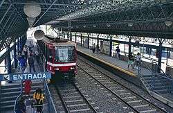
The Guadalajara light rail system (Spanish: Tren ligero de Guadalajara), which is operated by SITEUR (Sistema de Tren Eléctrico Urbano, Spanish for Urban Electrical Train System), is a light rail[1][2][4] system serving the municipalities of Guadalajara, Zapopan and Tlaquepaque, in the state of Jalisco, Mexico. It is owned by the state of Jalisco, and operator SITEUR is a state authority. Opened in 1989, the system currently has two lines: Line 1, running from north to south, with 19 stations, and Line 2, running from downtown to the east, with 10 stations.
History
The history of urban trains in Guadalajara dates back to the 19th century, with the first trams pulled by mules, going from the Cathedral to the Templo de la Merced.
In 1974, several houses and streets in the city center were demolished to make way for a wide new roadway, named Avenida Federalismo (Federal Avenue), and the construction of a new public-transport tunnel underneath. Avenida Federalismo (also known as Calzada del Federalismo) replaced what had been Moro St. (but with a much wider right-of-way) and is one of Guadalajara's most major thoroughfares. The 6.6-kilometre (4.1 mi) tunnel underneath the avenue was designed for future use by a rail system, but due to a lack of funding at the time it was initially served by a new trolleybus system, which opened on December 15, 1976.[1] Several years later, work began to convert the trolleybus tunnel and stations for use by a light rail line. The tunnel closed for trolleybuses in early 1988,[5] but trolleybus service continued on other routes and is still in operation. The first light rail line, Line 1, opened on September 1, 1989.[1]

A few years later, Line 2 was constructed, and it opened on July 1, 1994.[1] Because of the continuing heavy traffic congestion on the city's streets and the large numbers of users of the rail system, there are plans to extend Line 2 to the west and to build a third line.
Line 1 is underground in the city center, but runs "at grade" north and south of the city center, and its surface sections include several level crossings, protected by crossing gates. The station platforms accommodate trains no longer than two cars. Line 2 is entirely underground except for a non-passenger section at its east end, connecting the last station to the maintenance facility. Its stations are long enough to accommodate trains of up to four cars.
The German company Siemens supplied the system engineering, signaling and telecommunication, power supply, and some components of the vehicles.

Legend
| |||||||||||||||||||||||||||||||||||||||||||||||||||||||||||||||||||||||||||||||||||||||||||||||||||||||||||||||||||||||||||||||||||||||||||||||||||||||||||||||||||||||||||||||||||||||||||||||||||||||||||||||||||||||||||||||||||||||||||||||||||||||||||||||||||||||||||||||||||||||||||||||
Line 1
Line 1 runs from north (North Beltway) to south (South Beltway). It is 15.5 km (9.6 mi) long. Line 1 stations are:
- Periférico Norte (North Beltway)
- Dermatológico
- Atemajac
- División del Norte
- Ávila Camacho
- Mezquitán
- Refugio
- Juárez (Connection with Line 2)
- Mexicaltzingo
- Washington
- Santa Filomena
- Unidad Deportiva
- Urdaneta
- 18 de Marzo
- Isla Raza (Planned connection with Line 3)
- Patria
- España
- Santuario Mártires de Cristo Rey
- Periférico Sur (South Beltway)
Line 2
Line 2 runs from downtown (Juárez) to east (Tetlán), and is 8.8 km (5.5 mi) long. Its stations are:
- Juárez (Connection with Line 1)
- Plaza Universidad
- San Juan de Dios
- Belisario Domínguez
- Oblatos
- Cristóbal de Oñate
- San Andrés
- San Jacinto
- La Aurora
- Tetlán (Planned expansion of Line 2)
Fleet
The fleets consists of 48 articulated light rail vehicles,[6] each bi-directional ("double-ended") and powered from overhead lines. They have a top speed of 70 km/h (43 mph). All are the same general type and all were built in Mexico. The first 16 cars were built by Concarril,[1] and using propulsion equipment from Melmex (Mitsubishi Electric of Mexico).[7] For line 2, another 32 cars were ordered, and these came from Bombardier, which had acquired Concarril in 1992 and built this new batch in the same factory (in Ciudad Sahagún) as the earlier batch;[1] they have propulsion equipment from Siemens. The first batch were model TLG88, and the second were model TEG90.[3][7]
Expansion
Construction of the new Line 3[8] began at the end of 2014. The 21.4-kilometre (13.3 mi) line will feature a combination of underground (5.3 km) and elevated running (16.1 km) and include 18 stations. Line 3 will cross the full length of the city, from Zapopan in the north-west to Tlaquepaque and Tonalá, in the south-east, via the city centre.[9]
See also
- Trolleybuses in Guadalajara
- Guadalajara Macrobus
- Light rail in North America
- List of North American light rail systems by ridership
- List of Latin American rail transit systems by ridership
References
- 1 2 3 4 5 6 7 8 May, Jack. "Mexico Says Sí to LRT: Light Rail South of the Border". 1994 Light Rail Annual & User's Guide, pp. 5-7. Pasadena, CA (US): Pentrex. ISSN 0160-6913.
- 1 2 Webb, Mary (ed.) (2011). Jane's Urban Transport Systems 2011-2012, pp. "[20]" to "[22]" (in foreword). Coulsdon, Surrey (UK): Jane's Information Group. ISBN 978-0-7106-2954-8.
- 1 2 3 "Características Tren Eléctrico" [Electric Train Characteristics] (in Spanish). SITEUR. 2013. Retrieved 2013-07-24.
- ↑ World Systems List: Mexico (with introduction and country index here). Light Rail Transit Association (UK).
- ↑ Aberson, Gert. "Guadalajara Update". Trolleybus Magazine No. 190 (July–August 1993), pp. 87-92. National Trolleybus Assn. (UK). ISSN 0266-7452.
- ↑ "SITEUR - Sistema de transport electric urbano" [SITEUR - System of urban electric transport] (in Spanish). SITEUR. 2013. Retrieved 2013-07-24.
- 1 2 Webb, Mary (ed.) (2009). Jane's Urban Transport Systems 2009-2010, p. 240. Coulsdon (UK): Jane's Information Group. ISBN 978-0-7106-2903-6.
- ↑ Line 3 website: http://www.l3gdl.com/
- ↑ "Línea 3 del Tren Eléctrico de Guadalajara" (PDF). Línea 3 project website. Secretaría de Comunicaciones y Transportes, Jalisco. 2014. Retrieved 2015-08-10.
External links
| Wikimedia Commons has media related to Guadalajara light rail system. |
- SITEUR (Spanish)
- Guadalajara at UrbanRail.net
- Mapa del sistema en Google Earth (English)
Coordinates: 20°43′49″N 103°21′08″W / 20.73028°N 103.35222°W
| Commuter rail |  | |
|---|---|---|
| Rapid transit | ||
| Light rail | ||
| Trolleybus | ||
| Bus rapid transit | ||
| Multimodal operating authorities | ||
| Other transport |
| |