Grosse Pointe Farms, Michigan
| Grosse Pointe Farms, Michigan | ||
|---|---|---|
| City | ||
| City of Grosse Pointe Farms | ||
|
| ||
| ||
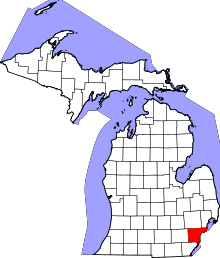
 Location in Wayne County and the state of Michigan | ||
| Coordinates: 42°24′18″N 82°54′3″W / 42.40500°N 82.90083°WCoordinates: 42°24′18″N 82°54′3″W / 42.40500°N 82.90083°W | ||
| Country | United States | |
| State | Michigan | |
| County | Wayne | |
| Government | ||
| • Mayor | James C Farquhar | |
| Area[1] | ||
| • Total | 12.32 sq mi (31.91 km2) | |
| • Land | 2.75 sq mi (7.12 km2) | |
| • Water | 9.57 sq mi (24.79 km2) | |
| Elevation | 607 ft (185 m) | |
| Population (2010)[2] | ||
| • Total | 9,479 | |
| • Estimate (2012[3]) | 9,316 | |
| • Density | 3,446.9/sq mi (1,330.9/km2) | |
| Time zone | EST (UTC-5) | |
| • Summer (DST) | EDT (UTC-4) | |
| ZIP codes | 48230, 48236 | |
| Area code(s) | 313 | |
| FIPS code | 26-35520[4] | |
| GNIS feature ID | 0627463[5] | |
| Website |
www | |

Grosse Pointe Farms is an affluent suburban town bordering Detroit located in Wayne County in the U.S. state of Michigan. The population was 9,479 at the 2010 census.[6] It is bordered by Canada and Lake Saint Clair on the south and east, Grosse Pointe on the west, Detroit on the north, and Grosse Pointe Woods and Grosse Pointe Shores on the northeast. Lakeshore Drive begins in Grosse Pointe Farms, where, just east of Fisher Road, the eastbound driver or pedestrian on Jefferson Avenue descends to lake level, following the curvature of the lakefront to the northeast.
History
The area that would become Grosse Pointe Farms was originally incorporated as the Village of Grosse Pointe in 1879. By 1889, the village extended from land just above Provenchal Road in the northeast to Cadieux Road in the west. In 1893, the portion of the village east of Fisher Road broke off and incorporated as the Village of Grosse Pointe Farms after a dispute over the location of a tavern.[7] It was not until 1949, however, that the village incorporated as a city.[7]
Geography
According to the United States Census Bureau, the city has a total area of 12.32 square miles (31.91 km2), of which 2.75 square miles (7.12 km2) is land and 9.57 square miles (24.79 km2) is water.[1] The water is part of Lake St. Clair.
The Farms has a more varied topography and streetscape than the other southern Grosse Pointes. While Grosse Pointe and Grosse Pointe Park are built on a standard street grid and are basically flat, Grosse Pointe Farms is partially built on the same grid flowing out of Detroit, but also features districts with irregular, curving street paths. A low but noticeable ridge runs through the center of the city. The Farms also contains the "point" in Grosse Pointe, where, just east of the Grosse Pointe War Memorial, there is a large bend in the lakeshore, such that those on the shoreline face east, instead of south, as they do when on the shoreline of neighboring Grosse Pointe, closer to the entrance of the Detroit River.
The cityscape varies widely, with large sections of old homes ranging from bungalows to mansions, and a few newer sections with ranch houses or luxury homes built on subdivided estates. The Farms has a downtown on Kercheval Avenue combining historic buildings with newer, neo-traditional storefronts.
Demographics
| Historical population | |||
|---|---|---|---|
| Census | Pop. | %± | |
| 1900 | 817 | — | |
| 1910 | 862 | 5.5% | |
| 1920 | 1,649 | 91.3% | |
| 1930 | 3,533 | 114.3% | |
| 1940 | 7,217 | 104.3% | |
| 1950 | 9,410 | 30.4% | |
| 1960 | 12,172 | 29.4% | |
| 1970 | 11,701 | −3.9% | |
| 1980 | 10,551 | −9.8% | |
| 1990 | 10,092 | −4.4% | |
| 2000 | 9,764 | −3.3% | |
| 2010 | 9,479 | −2.9% | |
| Est. 2015 | 9,232 | [8] | −2.6% |
2010 census
As of the census[2] of 2010, there were 9,479 people, 3,718 households, and 2,770 families residing in the city. The population density was 3,446.9 inhabitants per square mile (1,330.9/km2). There were 3,952 housing units at an average density of 1,437.1 per square mile (554.9/km2). The racial makeup of the city was 95.4% White, 1.8% African American, 0.2% Native American, 1.3% Asian, 0.4% from other races, and 1.0% from two or more races. Hispanic or Latino of any race were 2.0% of the population.
There were 3,718 households of which 33.7% had children under the age of 18 living with them, 66.0% were married couples living together, 6.2% had a female householder with no husband present, 2.3% had a male householder with no wife present, and 25.5% were non-families. 23.0% of all households were made up of individuals and 12.3% had someone living alone who was 65 years of age or older. The average household size was 2.55 and the average family size was 3.02.
The median age in the city was 45.1 years. 25.8% of residents were under the age of 18; 4.8% were between the ages of 18 and 24; 19.5% were from 25 to 44; 32.6% were from 45 to 64; and 17.5% were 65 years of age or older. The gender makeup of the city was 48.8% male and 51.2% female.
2000 census
At the 2000 census,[4] there were 9,764 people, 3,804 households, and 2,868 families residing in the city. The population density was 3,618.8 per square mile (1,396.3/km²). There were 3,937 housing units at an average density of 1,459.2 per square mile (563.0/km²). The racial makeup of the city was 97.58% White, 0.65% African American, 0.11% Native American, 1.13% Asian, 0.11% from other races, and 0.42% from two or more races. Hispanic or Latino of any race were 1.11% of the population.
There were 3,804 households of which 34.3% had children under the age of 18 living with them, 67.8% were married couples living together, 6.1% had a female householder with no husband present, and 24.6% were non-families. 22.3% of all households were made up of individuals and 12.0% had someone living alone who was 65 years of age or older. The average household size was 2.57 and the average family size was 3.03.
Age distribution was 26.5% under the age of 18, 3.6% from 18 to 24, 23.4% from 25 to 44, 28.6% from 45 to 64, and 17.9% who were 65 years of age or older. The median age was 43 years. For every 100 females there were 90.6 males. For every 100 females age 18 and over, there were 87.5 males.
The median household income was $100,153, and the median family income was $109,264. Males had a median income of $87,108 versus $53,241 for females. The per capita income for the city was $54,846. About 1.5% of families and 2.1% of the population were below the poverty line, including 3.1% of those under age 18 and 1.4% of those age 65 or over.
Climate
| Climate data for Grosse Pointe Farms, Michigan (1981–2010 normals, extremes 1950–present) | |||||||||||||
|---|---|---|---|---|---|---|---|---|---|---|---|---|---|
| Month | Jan | Feb | Mar | Apr | May | Jun | Jul | Aug | Sep | Oct | Nov | Dec | Year |
| Record high °F (°C) | 62 (17) |
69 (21) |
81 (27) |
90 (32) |
93 (34) |
105 (41) |
102 (39) |
101 (38) |
98 (37) |
90 (32) |
79 (26) |
69 (21) |
105 (41) |
| Average high °F (°C) | 31.2 (−0.4) |
33.8 (1) |
43.1 (6.2) |
56.0 (13.3) |
67.1 (19.5) |
77.2 (25.1) |
81.9 (27.7) |
79.6 (26.4) |
72.1 (22.3) |
59.7 (15.4) |
47.7 (8.7) |
35.7 (2.1) |
57.1 (13.9) |
| Daily mean °F (°C) | 23.8 (−4.6) |
25.9 (−3.4) |
34.1 (1.2) |
46.2 (7.9) |
57.2 (14) |
67.3 (19.6) |
72.0 (22.2) |
70.4 (21.3) |
62.8 (17.1) |
50.8 (10.4) |
39.8 (4.3) |
28.9 (−1.7) |
48.3 (9.1) |
| Average low °F (°C) | 16.4 (−8.7) |
17.9 (−7.8) |
25.0 (−3.9) |
36.3 (2.4) |
47.3 (8.5) |
57.3 (14.1) |
62.1 (16.7) |
61.3 (16.3) |
53.6 (12) |
42.0 (5.6) |
32.0 (0) |
22.1 (−5.5) |
39.4 (4.1) |
| Record low °F (°C) | −17 (−27) |
−12 (−24) |
−6 (−21) |
12 (−11) |
27 (−3) |
38 (3) |
44 (7) |
40 (4) |
32 (0) |
21 (−6) |
4 (−16) |
−10 (−23) |
−17 (−27) |
| Average precipitation inches (mm) | 1.80 (45.7) |
1.98 (50.3) |
2.41 (61.2) |
3.21 (81.5) |
3.39 (86.1) |
3.60 (91.4) |
3.64 (92.5) |
3.29 (83.6) |
3.42 (86.9) |
2.94 (74.7) |
2.95 (74.9) |
2.57 (65.3) |
35.20 (894.1) |
| Average snowfall inches (cm) | 9.0 (22.9) |
8.1 (20.6) |
3.6 (9.1) |
0.4 (1) |
0.0 (0) |
0.0 (0) |
0.0 (0) |
0.0 (0) |
0.0 (0) |
0.0 (0) |
0.6 (1.5) |
6.7 (17) |
28.4 (72.1) |
| Average precipitation days (≥ 0.01 in) | 10.1 | 7.6 | 9.0 | 11.9 | 11.2 | 10.5 | 10.0 | 9.6 | 9.6 | 10.4 | 10.4 | 11.0 | 121.3 |
| Average snowy days (≥ 0.1 in) | 4.7 | 3.4 | 1.6 | 0.4 | 0.0 | 0.0 | 0.0 | 0.0 | 0.0 | 0.0 | 0.5 | 3.4 | 14.0 |
| Source: NOAA[10][11] | |||||||||||||
Economy
The largest employer in Grosse Pointe Farms is the Henry Ford Medical Center.[12] The media company Saga Communications is based in Grosse Pointe Farms.
Education
Primary and secondary schools
The community is served by Grosse Pointe Public Schools (GPPSS). Public secondary schools within Grosse Pointe Farms include Grosse Pointe South High School and Brownell Middle School.
Public libraries
The Grosse Pointe Public Library operates the Central Branch in Grosse Pointe Farms.[13]
Notable people
- Elena Ford, is the daughter of Charlotte Ford, granddaughter of Henry Ford II, and great, great-granddaughter of Henry Ford.
- Meg White of The White Stripes grew up in Grosse Pointe Farms, according to her former husband, John "Jack" White, né Gillis.[14]
References
- 1 2 "US Gazetteer files 2010". United States Census Bureau. Retrieved 2012-11-25.
- 1 2 "American FactFinder". United States Census Bureau. Retrieved 2012-11-25.
- ↑ "Population Estimates". United States Census Bureau. Retrieved 2013-06-03.
- 1 2 "American FactFinder". United States Census Bureau. Retrieved 2008-01-31.
- ↑ U.S. Geological Survey Geographic Names Information System: Grosse Pointe Farms, Michigan
- ↑ "Race, Hispanic or Latino, Age, and Housing Occupancy: 2010 Census Redistricting Data (Public Law 94-171) Summary File (QT-PL), Grosse Pointe Farms city, Michigan". U.S. Census Bureau, American FactFinder 2. Retrieved September 7, 2011.
- 1 2 "History of Grosse Pointe". http://www.gphistorical.org/l. Grosse Pointe Historical Society. Retrieved 26 July 2014. External link in
|website=(help) - ↑ "Annual Estimates of the Resident Population for Incorporated Places: April 1, 2010 to July 1, 2015". Retrieved July 2, 2016.
- ↑ "Census of Population and Housing". Census.gov. Retrieved June 4, 2015.
- ↑ "NowData - NOAA Online Weather Data". National Oceanic and Atmospheric Administration. Retrieved July 29, 2016.
- ↑ "MI Grosse Pointe Farms". National Oceanic and Atmospheric Administration. Retrieved July 29, 2016.
- ↑ Grosse Pointe Farms 2010 CAFR
- ↑ "Hours & Location." Grosse Pointe Public Library. Retrieved on April 3, 2010.
- ↑ Nugent, Benjamin. "Music: White Lies and The White Stripes." Time. Saturday June 16, 2001. Retrieved on October 28, 2009.
External links
| Wikimedia Commons has media related to Grosse Pointe Farms, Michigan. |
 |
Grosse Pointe Woods | Grosse Pointe Shores | Lake St. Clair / |
|
| Detroit | |
Lake St. Clair / | ||
| ||||
| | ||||
| Grosse Pointe | Lake St. Clair |
Lake St. Clair / |
Municipalities and communities of Wayne County, Michigan, United States | ||
|---|---|---|
| Cities |
|  |
| Charter townships | ||
| General law townships | ||
| Unincorporated community | ||
| Footnotes | ‡This populated place also has portions in an adjacent county or counties | |
| Topics |  | |
|---|---|---|
| Detroit | ||
| Municipalities over 80,000 | ||
| Municipalities 40,000 to 80,000 | ||
| Cultural enclaves | ||
| Satellite cities | ||
| Counties in MSA | ||
| Counties in CSA | ||