Gros Ventre Range
| Gros Ventre Range | |
|---|---|
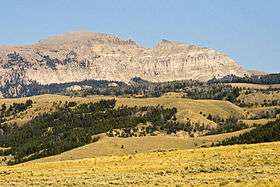 The "Sleeping Indian" on Sheep Mountain | |
| Highest point | |
| Peak | Doubletop Peak |
| Elevation | 11,720 ft (3,570 m) |
| Coordinates | 43°20′55″N 110°17′13″W / 43.34861°N 110.28694°WCoordinates: 43°20′55″N 110°17′13″W / 43.34861°N 110.28694°W |
| Geography | |
| Country | United States |
| State | Wyoming |
| Parent range | Rocky Mountains |
The Gros Ventre Range (/ˌɡroʊ ˈvɑːnt/ groh-VAHNT) is part of the Central Rocky Mountains and is located west of the Continental Divide in U.S. state of Wyoming. The highest summit in the range is Doubletop Peak at 11,720 feet (3,570 m).[1] The Gros Ventre Range is mostly within the Gros Ventre Wilderness of Bridger-Teton National Forest. To the northwest of the range lies the valley known as Jackson Hole. Snow King ski resort is in the range adjacent to the town of Jackson, Wyoming. Also in the Gros Ventre Range is the Gros Ventre landslide, which in 1925 slid down the north slope of Sheep Mountain.
Tallest peaks in the range
- 1. Doubletop Peak 11,720 feet (3,570 m)
- 2. Black Peak 11,657 feet (3,553 m)
- 3. Darwin Peak 11,647 feet (3,550 m)
- 4. Antoinette Peak 11,407 feet (3,477 m)
- 5. Tosi Peak 11,380 feet (3,470 m)
- 6. Sheep Mountain 11,239 feet (3,426 m)
- 7. Gros Peak 11,180 feet (3,410 m)
- 8. Pinnacle Peak 10,808 feet (3,294 m)
- 9. Jackson Peak 10,741 feet (3,274 m)
- 10. Mount Leidy 10,326 feet (3,147 m)[2]
Cited references
- ↑ "Doubletop Peak, Wyoming". Peakbagger.com. Retrieved 2010-11-21.
- ↑ "Gros Ventre Range". Peakbagger.com. Retrieved 2010-11-21.
This article is issued from Wikipedia - version of the 6/8/2014. The text is available under the Creative Commons Attribution/Share Alike but additional terms may apply for the media files.