Greenwood, Missouri
| Greenwood, Missouri | |
|---|---|
| City | |
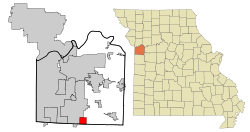 Location of Greenwood, Missouri | |
| Coordinates: 38°51′3″N 94°20′47″W / 38.85083°N 94.34639°WCoordinates: 38°51′3″N 94°20′47″W / 38.85083°N 94.34639°W | |
| Country |
|
| State |
|
| Counties |
Jackson Cass |
| Founded | 1867 |
| Government | |
| • Mayor | Marvin Megee |
| Area[1] | |
| • Total | 3.97 sq mi (10.28 km2) |
| • Land | 3.97 sq mi (10.28 km2) |
| • Water | 0 sq mi (0 km2) |
| Elevation | 942 ft (287 m) |
| Population (2010)[2] | |
| • Total | 5,221 |
| • Estimate (2012[3]) | 5,306 |
| • Density | 1,315.1/sq mi (507.8/km2) |
| Time zone | Central (CST) (UTC-6) |
| • Summer (DST) | CDT (UTC-5) |
| ZIP code | 64034 |
| Area code(s) | 816 |
| FIPS code | 29-29494[4] |
| GNIS feature ID | 0718834[5] |
Greenwood is a city in Jackson and Cass counties in the U.S. state of Missouri. The population was 5,221 at the 2010 census.
History
Greenwood was laid out in 1867.[6] A post office called Greenwood has been in operation since 1866.[7] The city was incorporated in 1963.[8]
Geography
Greenwood is located at 38°51′3″N 94°20′47″W / 38.85083°N 94.34639°W (38.850808, -94.346256).[9] According to the United States Census Bureau, the city has a total area of 3.97 square miles (10.28 km2).[1] The town has a small creek running through it in the Southwest. The area that constitutes Greenwood is mainly lightly wooded and open fields Northeast of its rail line, along with several small ponds. Southwest of the rails is mostly suburban housing along with a small downtown area.
Demographics
| Historical population | |||
|---|---|---|---|
| Census | Pop. | %± | |
| 1880 | 234 | — | |
| 1890 | 296 | 26.5% | |
| 1960 | 488 | — | |
| 1970 | 925 | 89.5% | |
| 1980 | 1,315 | 42.2% | |
| 1990 | 1,505 | 14.4% | |
| 2000 | 3,952 | 162.6% | |
| 2010 | 5,221 | 32.1% | |
| Est. 2015 | 5,569 | [10] | 6.7% |
2010 census
As of the census[2] of 2010, there were 5,221 people, 1,769 households, and 1,412 families residing in the city. The population density was 1,315.1 inhabitants per square mile (507.8/km2). There were 1,838 housing units at an average density of 463.0 per square mile (178.8/km2). The racial makeup of the city was 91.7% White, 5.1% African American, 0.3% Native American, 0.5% Asian, 0.7% from other races, and 1.7% from two or more races. Hispanic or Latino of any race were 3.4% of the population.
There were 1,769 households of which 51.0% had children under the age of 18 living with them, 66.2% were married couples living together, 8.9% had a female householder with no husband present, 4.7% had a male householder with no wife present, and 20.2% were non-families. 15.1% of all households were made up of individuals and 2.6% had someone living alone who was 65 years of age or older. The average household size was 2.95 and the average family size was 3.30.
The median age in the city was 32.2 years. 32.6% of residents were under the age of 18; 6.7% were between the ages of 18 and 24; 34% were from 25 to 44; 20.6% were from 45 to 64; and 6.2% were 65 years of age or older. The gender makeup of the city was 49.9% male and 50.1% female.
2000 census
As of the census[4] of 2000, there were 3,952 people, 1,352 households, and 1,122 families residing in the city. The population density was 978.3 people per square mile (377.7/km²). There were 1,407 housing units at an average density of 348.3 per square mile (134.5/km²). The racial makeup of the city was 95.07% White, 2.25% African American, 0.30% Native American, 0.46% Asian, 0.05% Pacific Islander, 0.56% from other races, and 1.32% from two or more races. Hispanic or Latino of any race were 2.10% of the population.
There were 1,352 households out of which 49.8% had children under the age of 18 living with them, 71.6% were married couples living together, 7.8% had a female householder with no husband present, and 17.0% were non-families. 13.2% of all households were made up of individuals and 2.1% had someone living alone who was 65 years of age or older. The average household size was 2.92 and the average family size was 3.21.
In the city the population was spread out with 32.6% under the age of 18, 6.0% from 18 to 24, 43.5% from 25 to 44, 12.9% from 45 to 64, and 4.9% who were 65 years of age or older. The median age was 30 years. For every 100 females there were 101.0 males. For every 100 females age 18 and over, there were 98.8 males.
The median income for a household in the city was $62,574, and the median income for a family was $65,313. Males had a median income of $42,173 versus $28,750 for females. The per capita income for the city was $21,586. About 2.9% of families and 3.9% of the population were below the poverty line, including 5.7% of those under age 18 and 9.4% of those age 65 or over.
Education
Greenwood is served by Lee's Summit R-VII School District. This includes Greenwood Elementary School located inside Greenwood and both Summit Lakes Middle School and Lee's Summit West High School located in southern Lee's Summit.
Transportation
Major roads
-
 Route 150 - A highway linking Greenwood to Southern Lee's Summit, Grandview, and to Overland Park at State Line Road.
Wildlife
Fauna
Greenwood has a very typical amount of biodiversity for the region it is in. There are Three species of snake that can be found in Greenwood, they are the garter snake, plain-bellied water snake and the ring-necked snake. In the creek you can also find the common snapping turtle. The creek also contains many toad and frog species including the bullfrog. Some white-tailed deer find portions of their range running through Greenwood. Many of Missouri's common spider species can be found in Greenwood such as the wolf spider, cellar spider, and brown recluse. Greenwood also contains a healthy opossum population. Small mammals such as the eastern cottontail, raccoon, and some mice species can be found be in small numbers. Greenwood's creek contains several species of fish including bluegills. Many species of birds such as the Canada goose and cardinal live in or migrate through Greenwood on a season to season basis. Many of Greenwoods households are home to domestic animals such as dogs and cats which are a common sight in the yards of Greenwood.
See also
- Kansas City Universities - List of Kansas City Area Colleges and Universities
- Lee's Summit schools – List of close private schools and colleges
- Lee's Summit Roads – List of close major roads
- Kansas City Universities - List of Kansas City Area Colleges and Universities
References
- 1 2 "US Gazetteer files 2010". United States Census Bureau. Retrieved 2012-07-08.
- 1 2 "American FactFinder". United States Census Bureau. Retrieved 2012-07-08.
- ↑ "Population Estimates". United States Census Bureau. Retrieved 2013-05-30.
- 1 2 "American FactFinder". United States Census Bureau. Retrieved 2008-01-31.
- ↑ "US Board on Geographic Names". United States Geological Survey. 2007-10-25. Retrieved 2008-01-31.
- ↑ "Jackson County Place Names, 1928–1945 (archived)". The State Historical Society of Missouri. Retrieved 16 October 2016.
- ↑ "Post Offices". Jim Forte Postal History. Retrieved 16 October 2016.
- ↑ "Our History". City of Greenwood, MO. Retrieved 17 October 2016.
- ↑ "US Gazetteer files: 2010, 2000, and 1990". United States Census Bureau. 2011-02-12. Retrieved 2011-04-23.
- ↑ "Annual Estimates of the Resident Population for Incorporated Places: April 1, 2010 to July 1, 2015". Retrieved July 2, 2016.
- ↑ "Census of Population and Housing". Census.gov. Retrieved June 4, 2015.
External links
Municipalities and communities of Jackson County, Missouri, United States | ||
|---|---|---|
| Cities | 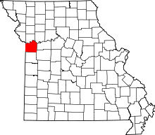 | |
| Villages | ||
| Townships | ||
| Unincorporated communities | ||
| Footnotes | ‡This populated place also has portions in an adjacent county or counties | |
Municipalities and communities of Cass County, Missouri, United States | ||
|---|---|---|
| Cities | 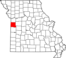 | |
| Villages | ||
| Townships | ||
| Unincorporated communities | ||
| Ghost towns | ||
| Footnotes | ‡This populated place also has portions in an adjacent county or counties | |
Kansas City metropolitan area's cities and counties | ||
|---|---|---|
| Central city |  | |
| Largest cities (over 100,000 in 2000) | ||
| Medium-sized cities (10,000 to 100,000 in 2000) | ||
| Smaller Cities (between 5,000 and 9,900 in 2010) | ||
| Counties | ||