Prime meridian (Greenwich)
Coordinates: 51°28′40.12″N 0°00′05.31″W / 51.4778111°N 0.0014750°W


A prime meridian, based at the Royal Observatory, Greenwich, in London,[1] was established by Sir George Airy in 1851. By 1884, over two-thirds of all ships and tonnage used it as the reference meridian on their charts and maps. In October of that year, at the behest of U.S. President Chester A. Arthur, 41 delegates from 25 nations met in Washington, D.C., United States, for the International Meridian Conference. This conference selected the meridian passing through Greenwich as the official prime meridian due to its popularity.[note 1] However, France abstained from the vote and French maps continued to use the Paris meridian for several decades. In the 18th century, London lexicographer, Malachy Postlethwayt published his African maps showing the 'Meridian of London' intersecting the Equator a few degrees west of the later meridian and Accra, Ghana.[3]
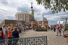
The prime meridian passes through the Airy transit circle (51°28′40.1″N 0°0′5.3″W / 51.477806°N 0.001472°W)[4] of the Greenwich observatory. It was long marked by a brass strip in the courtyard, now replaced by stainless steel, and, since 16 December 1999, has been marked by a powerful green laser shining north across the London night sky.
Global Positioning System (GPS) receivers show that the marking strip for the prime meridian at Greenwich is not exactly at zero degrees, zero minutes and zero seconds but at approximately 5.3 seconds of arc to the west of the meridian (meaning that the meridian appears to be 102 metres east of this line). In the past, this offset has been attributed to the establishment of reference meridians for space-based location systems such as WGS 84 (which GPS relies on) or that errors gradually crept into the International Time Bureau timekeeping process. The actual reason for the discrepancy is that the marking strip is indeed at astronomical longitude zero degrees, zero minutes and zero seconds—but GPS receivers show geodetic longitude.
History
Before the establishment of a common meridian, most maritime countries established their own prime meridian, usually passing through the country in question. In 1721, Great Britain established its own meridian passing through an early transit circle at the newly established Royal Observatory at Greenwich. The meridian was moved around 10 metres or so east on three occasions as transit circles with newer and better instruments were built, on each occasion next door to the existing one. This was to allow uninterrupted observation during each new construction. The final meridian was established as an imaginary line from the north pole to the south pole passing through the Airy transit circle. This became Great Britain's meridian in 1851.[5] For all practical purposes of the period, the changes as the meridian was moved went unnoticed.
Transit instruments are installed to be perpendicular to the local level (which is a plane perpendicular to a plumb line). In 1884, the International Meridian Conference took place to establish an internationally recognised single meridian. The meridian chosen was that which passed through the Airy transit circle at Greenwich and it became the prime meridian.
At around the time of this conference, scientists were making measurements to determine the deflection of the vertical on a large scale.[6] One might expect that plumb lines set up in various locations, if extended downward, would all pass through a single point, the centre of the Earth, but this is not the case, primarily due to the Earth being flattened and not a sphere. The downward extended plumb lines don't even all intersect the rotation axis of the Earth; this much smaller effect is due to the uneven distribution of the Earth's mass. To make computations feasible, scientists defined ellipsoids of revolution; a given ellipsoid would be a good compromise for measurements in a given area, such as a country or continent. The difference between the direction of a plumb line or vertical, and a line perpendicular to the surface of the ellipsoid of revolution—a normal to said ellipsoid—at a particular observatory, is the deflection of the vertical.[7]
When the Airy transit circle was built, a mercury basin was used to align the telescope to the perpendicular. Thus the circle was aligned with the local vertical or plumb line, which is deflected slightly from the normal, or line perpendicular, to the reference ellipsoid used to define geodetic latitude and longitude in the International Terrestrial Reference Frame (which is nearly the same as the WGS-84 system used by GPS). While the local vertical defined at the Airy transit circle still points to the modern celestial meridian (the intersection of the prime meridian plane with the celestial sphere), it does not pass through the Earth's rotation axis. As a result of this, the ITRF zero meridian, defined by a plane passing through the Earth's rotation axis, is 102 metres to the east of the prime meridian. A 2015 analysis by Malys et al. shows the offset between the Airy transit circle and the ITRF/WGS 84 meridians can be explained by this deflection of the vertical alone; other possible sources of the offset that have been proposed in the past are smaller than the current uncertainty in the deflection of the vertical near the observatory. The astronomical longitude of the Greenwich prime meridian was found to be 0.19″ ± 0.47″ East, i.e. the plane defined by the local vertical on the Greenwich prime meridian and the plane passing through the Earth's rotation axis on the ITRF zero meridian are effectively parallel. However, the claim, found, e.g., in a BBC article that this difference between astronomical and geodetic coordinates means that any measurements of transit time across the IRTF zero meridian will occur 0.352 seconds (or 0.353 sidereal seconds) before the transit across the "intended meridian"[8] is based on a failure of understanding. The explanation by Malys et al.[4] on the other hand is both lucid and correct.
The meridian today
As of 2016 the Greenwich meridian passes through:
-
 United Kingdom,
 -
 France,
 -
 Spain,
 -
 Algeria,
 -
 Mali,
Mali, -
 Burkina Faso,
 -
 Togo,
Togo, -
 Ghana,
 -
 Ashantiland Peninsula,
 -
 Queen Maud Land in Antarctica.
See also
Notes
References
- ↑ ROG Learing Team (23 August 2002). "The Prime Meridian at Greenwich". Royal Museums Greenwich. Royal Museums Greenwich. Retrieved 14 June 2012.
- ↑ Howse 1997, pp. 12, 137.
- ↑ Malachy Postlethwayt. (1774) Universal Dictionary of Trade and Commerce. (4th edition) London: W. Strahan, J. & F. Rivington. Vol. 1 "A New and Correct Map of the Coast of Africa".
- 1 2 Malys, Stephen; Seago, John H.; Palvis, Nikolaos K.; Seidelmann, P. Kenneth; Kaplan, George H. (1 August 2015). "Why the Greenwich meridian moved". Journal of Geodesy. doi:10.1007/s00190-015-0844-6.
- ↑ "The Greenwich Meridian".
- ↑ Dracup, Joseph F. (8 June 2006). "Geodetic Surveys in the United States, the Beginning and the Next 100 Years". NOAA History: A Science Odyssey.
- ↑ Geodesy for the Layman (PDF) (Technical report) (5th ed.). National Ocean Service. December 1983. pp. 6–10.
- ↑ "Scientists explain why Greenwich Meridian line is in 'wrong place'". BBC News. Archived from the original on 2015-08-17.
- Howse, Derek (1997). Greenwich Time and the Longitude. Phillip Wilson. ISBN 0-85667-468-0.
External links
| Wikimedia Commons has media related to Prime meridian. |
- "Where the Earth's surface begins—and ends", Popular Mechanics, December 1930
- International Conference Held at Washington for the Purpose of Fixing a Prime Meridian at Project Gutenberg
- A pictorial catalogue of meridian markers