Buzzard Point
Coordinates: 38°52′19″N 77°00′40″W / 38.872°N 77.011°W
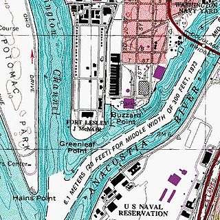

Buzzard Point is an urbanized area located on the peninsula formed by the confluence of the Potomac and Anacostia Rivers in the southwest quadrant of Washington, DC, USA.[1]
History
The earliest documented name for the tip of the peninsula that now constitutes the area known as Buzzard Point was Turkey Buzzard Point, in use by 1673 when it appeared on a map published by Augustine Herman, a Bohemian explorer and one of the early settlers of the Eastern Shore of Maryland.[2] This name — often shortened to Buzzard Point — remained in use until the federal capital was laid out in the 1790s, at which time it became Young's Point, from one Notley Young, the then owner of the land. Very soon thereafter it was renamed Greenleaf's Point — or Greenleaf Point — after James Greenleaf, a land speculator and purchaser of numerous lots in the new city, many of which were located in the vicinity of the Point.[2]
George Washington had envisioned the use of some of Greenleaf's lots at the Point by the military, including for defensive works. In 1791, he and Pierre (Peter) Charles L'Enfant chose the site for the emplacement of a redoubt of some sort.[3] They acquired approximately 28 acres (110,000 m2) by a deed of trust in that year and confirmed it in a July 25, 1798 executive order. Apparently, L'Enfant intended for a fortification to be placed there, according to his city plan, setting it aside as "Military District No. 5", because, as one author wrote, the "peninsula where the Potomac and Anacostia Rivers met was an obvious, natural military site." This site, sported a "one-gun battery mounted behind earth breastworks," possibly as early as 1791 but, at any rate, definitely by 1794. Within a few years, "The U.S. Arsenal at Greenleaf Point" grew from 28 to more than 89 acres (360,000 m2). By 1803, the "Fort" was first referred to as an "Arsenal" and Congress provided money for the construction of additional buildings.
During the American Civil War, experiments on new weaponry were carried out both at the nearby Washington Navy Yard and at the Washington Arsenal as the Army installation had come to be called. Breechloaders, the Spencer carbine, and the Gatling gun were among the weapons tested on the peninsula. In 1908, the tip of the peninsula bore the name of Arsenal Point because of its military use at the time.[2] Washington Arsenal was renamed Fort Lesley J. McNair in 1948.
From its earliest times the Point was largely ignored by the larger population of the District, much as in a larger sense all of Southwest Washington (referred to as “The Island” for its isolation) remained somewhat separated. L’Enfant’s and Washington’s hopes for bustling river traffic at Buzzard Point wharves never came to be; instead, the area south of Q Street SW and between South Capitol and the Fort took on a noticeably rural air. Wrote an early resident of this period: “From the Navy Yard westward along the Eastern Branch [the Anacostia] to Greenleaf’s Point was a wild stretch of land with here and there a hovel or a house, and a stouring of brick kilns.”[4] The marshy James Creek, flowing alongside the Arsenal (canalized in 1866 as the James Creek Canal and connected briefly to the existing Washington Canal) served only as a source of disease and magnet for trash dumps.
An 1875 survey of Buzzard Point (below Q) found only 36 residences, 8 “shanties” and 6 businesses, and these figures hardly increased over the years.[5] Census figures show the population peaking at 323 in 1894 (this from the Police Census for that year, found in the Metropolitan Police Annual Report) and then falling gradually: 231 in 1900; 185 in 1920; 19 in 1940. The area always claimed an almost perfect balance between black and white residents, generally living side-by-side and all of the working class. “Farmer” was the most common profession up to about 1920, when “driver” replaced it.
The few accounts of this 1880-1920 period picture a modest community largely dominated by tidy truck gardens to the south and west and workers’ houses and some small businesses along the eastern border (South Capitol to First St SW).”It is bordered on either side by true market gardens in the highest state of cultivation. The fields are interspaced with orchards of small fruit trees and occasionally these miniature farms have buildings set back from the road and profusely surrounded with chickens, stables and farm implements.”[6] The neighborhood understandably had a clannish feel, and was seldom visited by outsiders: “A stranger is a very strange thing on Buzzard Point.”[7]
Deterioration had clearly set in by the 1910s as fields were abandoned and the trash-strewn James Creek Canal was progressively filled in. Unpleasant semi-industrial uses crept down South Capitol Street, most notably trash removal – refuse was hauled (legally or otherwise) to various points along that street and the Anacostia, and also dumped into the river through the District’s new sewage system. As the population declined District planners looked for other uses for this neglected but close-in area. (It is important to remember that there was no bridge crossing from Buzzard Point across the Anacostia until 1950.)
The District’s new zoning system of 1920 optimistically brought industrial zoning to the Point, followed by the 1929 National Capitol Parks and Planning Commission’s development planning report envisioning the area covered with railroad spurs and new large-scale manufacturing and utility uses that were unwelcome in other parts of town. This concerted effort destroyed what little was left of the old rural area without bringing in more than the railroad lines, the magnificent 1933 PEPCO power plant, and an oil/gas storage facility. Through the mid- and late-twentieth century these two major facilities and adjoining smaller ones mostly closed as new development loomed from the nearby Navy Yard area. Some boat yards and marinas maintained themselves on National Park Service-owned land along the Anacostia River.
Buzzard Point today

The United States Geological Survey's (USGS) most recent topographic maps identify the tip of the peninsula that contains Fort McNair as "Greenleaf Point".[8] The USGS maps also identify a lesser point to the northeast of Greenleaf Point as "Buzzard Point".[8] (James Creek, which was excavated in the 19th century to become a branch of the [now defunct] Washington City Canal, once separated these two points. Its name persists in the present day James Creek Marina, located between the two named points. In early days, James Creek was also known as St. James Creek.)
Although officially the name of only the tip of the peninsula, the term "Buzzard Point" now serves to identify much or all of an urbanized area south of M Street SW and west of South Capitol Street SW, excluding Fort McNair. The area has long been known as a rather grim industrial backwater of the city. Buzzard Point is close to Nationals Park, and not far from the Waterfront and Navy Yard – Ballpark Metro stations. The Buzzard Point waterfront extends from the Fort along the west bank of the Anacostia River as far as South Capitol Street at the Frederick Douglass Memorial Bridge. Moving west to east along it from the Fort are the James Creek Marina, the former headquarters of the U.S. Coast Guard, Buzzard Point Marina and Buzzard Point Park.
In 2007, Pepco Holdings announced that it sought to retire the Buzzard Point power plant by 2012.[9]
On July 25, 2013, a tentative deal was announced which will see a 20,000-seat stadium for the D.C. United soccer team built at Buzzard Point and costing $300 million.[10][11]
References
Citations
- ↑ "Buzzard Point" in Google Maps. Accessed 2009-11-17.
- 1 2 3 Taggart, Hugh T. (1908), Georgetown (District of Columbia); Reprinted from Records of the Columbia Historical Society, Vol. 11, 1908; Lancaster, Pennsylvania: The New Era Printing Company, pages 9 & 11.
- ↑ L'Enfant identified himself as "Peter Charles L'Enfant" during most of his life, while residing in the United States. He wrote this name on his "Plan of the city intended for the permanent seat of the government of t(he) United States ...." (Washington, D.C.) and on other legal documents. However, during the early 1900s, a French ambassador to the U.S., Jean Jules Jusserand, popularized the use of L'Enfant's birth name, "Pierre Charles L'Enfant". (See: Bowling (2002).) The National Park Service identifies L'Enfant as Major Peter Charles L'Enfant and as Major Pierre (Peter) Charles L'Enfant on its website. The United States Code states in 40 U.S.C. 3309: "(a) In General.—The purposes of this chapter shall be carried out in the District of Columbia as nearly as may be practicable in harmony with the plan of Peter Charles L'Enfant."
- ↑ Sunderland, Bryan, “Washington As I Knew It”, in Records of the Columbian Historical Society, vol. 5. CHS, Washington DC. 1902.)
- ↑ Kraft, Brian D., Old Southwest: A History of a Vanished Neighborhood. MS. 2006 (at Washingtoniana Div of MLK Library, Washington DC).
- ↑ Wash Post, 21 Nov 1886, p. 7.
- ↑ Evening Star, 30 July 1916, p. 48.
- 1 2 United States Geological Survey topographic map with locations of Greenleaf Point and Buzzard Point in website of TopoQuest. Retrieved 2009-11-17.
- ↑ Pepco Holdings. (2007, February 28). Benning Road and Buzzard Point Units to be retired by 2012 [Press release].
- ↑ "Deal reached for new stadium". StadiaDirectory. July 25, 2013. Retrieved July 25, 2013.
- ↑ "Term Sheet: DC United Stadium Project" (PDF). District of Columbia and DC Soccer LLC. District of Columbia Office of the City Administrator. July 25, 2013. Archived from the original (PDF) on 2016-03-04.
Further reading
- Wetzel, Hayden M., Buzzard Point, DC: A Brief History of a Brief Neighborhood. Privately printed, 2014. (Available at the Historical Society of Washington library)