Green Lanes (London)
Green Lanes, London, (N16, N4, N8, N13 and N21) is a main road in North London and forms part of the A105. Covering a distance of 6.3 miles (10.14 km)[1] between Newington Green and Winchmore Hill, it is one of the longest streets in the capital.
History
Green Lanes is an ancient thoroughfare, originally a drovers' road along which cattle were walked from Hertfordshire towards Smithfield Market in London.
Route
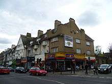
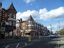
It runs from Newington Green north along the western edge of Stoke Newington, thereby forming the border between Hackney and Islington, until it reaches Manor House at the eastern edge of Finsbury Park. Entering the London Borough of Haringey, it then runs 1.4 miles (2.25 km)[2] through the neighbourhood of Harringay. From the junction with Turnpike Lane the road temporarily changes its name and runs for 1.3 miles (2.1 km)[3] through Wood Green as 'High Road', resuming its Green Lanes identity again after the junction with Lascotts Avenue. It then continues north for another 2.2 miles (3.5 km)[4] through Palmers Green and Winchmore Hill in the London Borough of Enfield, until it reaches the junction with Ridge Avenue and Green Dragon Lane at Mason's Corner. The northward continuation into Bush Hill at this point is now blocked.
Sights
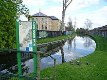
Amongst the sights along its route are Clissold Park, the former Engine House of Metropolitan Water Board,[5] Finsbury Park, the New River (which follows a roughly parallel course for some distance), Railway Fields Nature Reserve, the Salisbury Public House and Turnpike Lane Underground Station. In Harringay, there are also the sites of the now demolished Harringay Stadium and Harringay Arena.
Demography
In Newington Green and Harringay there is a strong presence of the Turkish and Kurdish communities. Much of the settlement of the Greek and Greek Cypriot community who had made their home in this part of London has now moved further north to Palmers Green.[6]
Neighbourhoods
Neighbourhoods sited on Green Lanes, from South to North:
- Newington Green
- Manor House
- Harringay (including Finsbury Park)
- Wood Green
- Palmers Green
- Winchmore Hill
References
- ↑ Distance between the southern and northern ends of Green Lanes, as measured by Google Maps. Through Wood Green, for 1.3 miles of its route, the road name changes to 'High Road'. If this section is excluded, the total interrupted length of Green Lanes is 5 miles.
- ↑ Distance between the southern and northern end of Harringay ward, as measured by Google Maps
- ↑ Distance between the junction of Green Lanes and Turnpike Lane and the junction with Lascott's Avenue, as measured by Google Maps
- ↑ Distance between the junction of Green Lanes and Lascott's Avenue and the junction with Ridge Avenue/Green Dragon Lane, as measured by Google Maps
- ↑ The Engine House is now the [Castle Climbing Centre http://www.castle-climbing.co.uk]
- ↑ Benedictus, Leo (2005-01-21). "Every race, colour, nation and religion on earth - part two". The Guardian. ISSN 0261-3077. Retrieved 2016-04-24.
External links
![]() Media related to Green Lanes, London at Wikimedia Commons
Media related to Green Lanes, London at Wikimedia Commons
Coordinates: 51°35′01″N 0°06′00″W / 51.5835°N 0.0999°W