Greece (town), New York
| Town of Greece | |
| Town | |
 Greece Town Seal | |
| Motto: Discover the Promise | |
| Country | United States |
|---|---|
| State | New York |
| County | Monroe |
| Elevation | 424 ft (129.2 m) |
| Coordinates | 43°12′34″N 77°41′43″W / 43.20944°N 77.69528°WCoordinates: 43°12′34″N 77°41′43″W / 43.20944°N 77.69528°W |
| Area | 51.4 sq mi (133.1 km2) |
| - land | 47.4 sq mi (123 km2) |
| - water | 3.9 sq mi (10 km2), 7.59% |
| Population | 96,095 (2010) |
| Density | 2,022/sq mi (780.699/km2) |
| Established | 1822 |
| Town Supervisor | William D. Reilich (R) First Elected 2013
|
| Timezone | EST (UTC-5) |
| - summer (DST) | EDT (UTC-4) |
| ZIP code | 14612, 14615, 14616, 14626 |
| Area code | 585 |
 Location in Monroe County and the state of New York.
| |
 Location of New York in the United States
| |
| Website: http://www.greeceny.gov/ | |
Greece is a town in Monroe County, New York, United States. As of the 2010 United States census, the town had a total population of 96,095. The town motto is "Discover the Promise."
The Town of Greece is in the northern part of the county and borders the City of Rochester on the east, the Town of Gates on the south, the towns of Parma and Ogden on the west, and Lake Ontario on the north. The town is a contiguous suburb of Rochester. The area known as Charlotte, on the eastern border, was formerly part of the town until it was annexed by the City of Rochester in 1916.
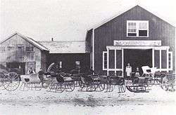
History
The Town of Greece was established in 1822 from part of the Town of Gates and was previously called Northampton. The name "Greece" was selected because of the contemporary struggle of Greece for independence from the Ottoman Empire.
The region that the town now occupies was originally settled by the Algonquian and Iroquois Native Americans in the 14th century. The first European to visit the area was the French explorer Rene-Robert Cavelier, who visited in 1669.[1] European settlers began to arrive in the area in the 1790s, and French and British soldiers passed through on multiple occasions during this time period as the two colonial powers struggled to control the region.
According to the Morgan Quitno Awards, Greece was rated the ninth overall safest city in America and the sixth safest city with a population of 75,000 to 99,999.[2]
The William Payne House, Greece Memorial Hall, William Covert Cobblestone Farmhouse, and Our Mother of Sorrows Roman Catholic Church Complex are listed on the National Register of Historic Places.[3][4]
| Name | Term | Name | Term | Name | Term | ||
|---|---|---|---|---|---|---|---|
| John Williams | 1822 1830 | Peter Larkin | 1861–1862 1872 1876 | Frank Vance | 1902–Feb 14, 1903 | ||
| Frederick Bushnell | 1823–1825 | Harry A. Olmsted | 1863 | Willis N. Britton | Feb 25, 1903 | ||
| Silas Walker | 1826–1829 | Nelson Lewis | 1864–1869 | Frank Truesdale | 1904–1909 | ||
| Elijah Hughitt | 1831 | Simon Butts | 1870–1871 | Frank Dobson | 1910–1915 | ||
| Giles H. Holden | 1832–1833 | David Todd | 1874–1875 | Herbert J. Paine | 1916–1921 | ||
| Asa Rowe | 1834–1835 1842 | Alanson P. Britton | 1877–1878 1884–1885 1887 1893 April 29, 1901–December 31, 1901 | Frank J. Mitchell | 1922–1927 | ||
| Samuel Bradley | 1836–1838 | John Lowden | 1879–1880 | William F. Schmitt | 1928–1933 | ||
| Lyman Langworthy | 1839–1841 1850 | John Kintz | 1881 | Gordon A. Howe | 1934–1960 | ||
| Abdial Carpenter | 1843 1848 | Erastus Benedict | 1882–1883 | Vincent L. Tofany | 1960–1964 | ||
| George C. Salter | 1844 | Lucien A. Rowe | 1886 | George W. Badgerow | 1965–1969 | ||
| George C. Latta | 1845 1849 | John M. Lowdon | 1888–1889 | Fred J. Eckert | 1970–1972 | ||
| James S. Stone | 1846–1847 1853 | Thomas Eddy | 1890 | Donald J. Riley | 1973–1989 | ||
| Levi H. Parrish | 1851–1852 | Joseph R. Beaty | 1891–1892 | Roger W. Boily | 1989–1997 | ||
| Elias Avery | 1854–1855 | James B. Castle | 1894–1897 | John T. Auberger | 1998–2013 | ||
| Erastus Walker | 1856–1857 1873 | Edward Frisbee | 1898–February 27, 1901 | William D. Reilich | 2014-present | ||
| Joshua Eaton | 1858 | William T. Whelehan | March 1, 1901–March 27, 1901 | ||||
| Alamander Wilder | 1859 | Charles H. Banker | March 27, 1901–April 24, 1901 |
Geography
Greece is located at 43o 14' N latitude, 077o 42' W longitude.
According to the United States Census Bureau, the town has a total area of 51.4 square miles (133.0 km²), of which, 47.4 square miles (122.8 km²) of it is land and 3.9 square miles (10.2 km²) of it (7.65%) is water.
Major highways in the town include NY 390 and the Lake Ontario State Parkway. As that suggests, the town borders Lake Ontario.
Demographics
| Historical population | |||
|---|---|---|---|
| Census | Pop. | %± | |
| 1830 | 2,574 | — | |
| 1840 | 3,669 | 42.5% | |
| 1850 | 4,219 | 15.0% | |
| 1860 | 4,147 | −1.7% | |
| 1870 | 4,314 | 4.0% | |
| 1880 | 4,848 | 12.4% | |
| 1890 | 5,145 | 6.1% | |
| 1900 | 5,579 | 8.4% | |
| 1910 | 7,777 | 39.4% | |
| 1920 | 3,350 | −56.9% | |
| 1930 | 12,113 | 261.6% | |
| 1940 | 14,925 | 23.2% | |
| 1950 | 25,508 | 70.9% | |
| 1960 | 48,670 | 90.8% | |
| 1970 | 75,136 | 54.4% | |
| 1980 | 81,367 | 8.3% | |
| 1990 | 90,106 | 10.7% | |
| 2000 | 94,141 | 4.5% | |
| 2010 | 96,095 | 2.1% | |
| Est. 2014 | 97,084 | [5] | 1.0% |
As of the census[7] of 2000, there were 94,141 people, 36,995 households, and 25,748 families residing in the town. The population density was 1,985.0 people per square mile (766.4/km²). There were 38,315 housing units at an average density of 807.9 per square mile (311.9/km²). The racial makeup of the town was 93.37% White, 2.88% Black or African American, 0.24% Native American, 1.49% Asian, 0.03% Pacific Islander, 0.87% from other races, and 1.12% from two or more races. Hispanic or Latino of any race were 2.55% of the population.
There were 36,995 households out of which 32.5% had children under the age of 18 living with them, 55.6% were married couples living together, 10.4% had a female householder with no husband present, and 30.4% were non-families. 25.6% of all households were made up of individuals and 11.1% had someone living alone who was 65 years of age or older. The average household size was 2.52 and the average family size was 3.05.
In the town the population was spread out with 25.0% under the age of 18, 7.0% from 18 to 24, 28.4% from 25 to 44, 24.2% from 45 to 64, and 15.3% who were 65 years of age or older. The median age was 39 years. For every 100 females there were 92.3 males. For every 100 females age 18 and over, there were 88.1 males.
The median income for a household in the town was $48,355, and the median income for a family was $57,102. Males had a median income of $41,563 versus $29,864 for females. The per capita income for the town was $22,614. About 3.6% of families and 4.8% of the population were below the poverty line, including 6.3% of those under age 18 and 5.5% of those age 65 or over.
Government

The town is governed by a town board consisting of a supervisor and four council members. The supervisor is elected by all registered voters in the town, while council members are elected by and represent one of four wards. Supervisors are elected for four-year terms, and by town law may not serve for more than twelve years consecutively, after which the individual is ineligible to serve for four years. Councilpersons are elected for two-year terms, and may serve for a maximum of ten consecutive years in that position.[8]
The town board's practice of opening each meeting with a prayer, which started in 1999, was legally challenged in 2008,[9] on the grounds that all prayers offered to open the meetings had, until that point, been Christian ones.[10] The United States District Court, Western District of New York, ruled in favor of the town in 2010,[11] and the Second Circuit Court of Appeals reversed that decision in 2012,[12] setting the stage for a 2014 decision by the Supreme Court of the United States which ruled in favor of the town in the case Town of Greece v. Galloway.[13]
Education
There are three school districts serving the Town of Greece: the Greece Central School District, the Hilton Central School District and the Spencerport Central School District.
There are twelve elementary schools, four middle schools, and four high schools in the Greece Central School District, educating approximately 13,000 students. The post-elementary schools have Classical Greek names: Arcadia, Athena, Apollo, Odyssey Academy, and Olympia. The school district's motto is "One Vision, One Team, One Greece." Among the elementary schools, Brookside, Longridge, Paddy Hill, Pine Brook and West Ridge span K-5.
Communities and locations in Greece
- Barnard—Community near Dewey Ave., Stone Road, and Maiden Lane.
- Braddock Bay—A bay off of Lake Ontario and a state park in the northwest section of the town, north of the Lake Ontario State Parkway on East Manitou Road.
- Braddock Heights—A community near Braddock Bay.
- Elmgrove—Area around Elmgrove Road.
- Grandview Heights—West side of Long Pond, off Lowden Point Road, just south of Edgemere Drive.
- Grand View Beach—Edgemere Drive west of Lowden Point Road, opposite Cranberry Pond.
- North Greece—Near Latta Road (Rt. 18) and North Greece Rd. (Zip Code 14515).
- West Greece—Near West Ridge Road (Rt. 104) and Manitou Road (Rt. 261); destination of the Route 14 bus.
See also
References
- ↑ "Town History". All About Greece. The Town of Greece. Retrieved 22 January 2013.
- ↑ 13th Annual America's Safest (and Most Dangerous) Cities
- ↑ National Park Service (2010-07-09). "National Register Information System". National Register of Historic Places. National Park Service.
- ↑ "National Register of Historic Places Listings". Weekly List of Actions Taken on Properties: 6/18/12 through 6/22/12. National Park Service. 2012-06-29.
- ↑ "Annual Estimates of the Resident Population for Incorporated Places: April 1, 2010 to July 1, 2014". Retrieved June 4, 2015.
- ↑ "Census of Population and Housing". Census.gov. Retrieved June 4, 2015.
- ↑ "American FactFinder". United States Census Bureau. Retrieved 2008-01-31.
- ↑ "Code of the Town of Greece, chapter 45". Retrieved 8 September 2013.
- ↑ Mehta, Hemant (2013-08-16). "Everything You Need to Know About Town of Greece v. Galloway, the Supreme Court Case About Government Prayer". Friendly Atheist. Patheos. Retrieved 8 September 2013.
- ↑ Lund, Christopher C. (2013-08-15). "Legislative Prayer Goes Back to the Supreme Court". Slate.com. The Slate Group. Retrieved 8 September 2013.
- ↑ "Galloway v Greece". Google Scholar. Retrieved 8 September 2013.
- ↑ "Decision of Court ofAppeals". Google Scholar. Retrieved 8 September 2013.
- ↑ Liptak, Adam (May 5, 2014). "Town Meetings Can Have Prayer, Justices Decide". The New York Times. Retrieved May 5, 2014.
External links
- Town of Greece webpage
- Greece Chamber of Commerce
- Greece Central School District
- Hilton Central School District
- Greece Historical Society and Museum
Municipalities and communities of Monroe County, New York, United States | ||
|---|---|---|
| City | 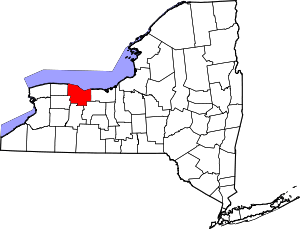 | |
| Towns | ||
| Villages | ||
| CDPs | ||
| Other hamlets | ||
| Footnotes | ‡This populated place also has portions in an adjacent county or counties | |