Greater Sunda Islands
 | |
| Geography | |
|---|---|
| Location | South East Asia |
| Coordinates | 0°00′N 110°00′E / 0.000°N 110.000°E |
| Archipelago | Sunda Islands |
| Administration | |
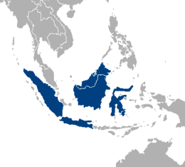
The Greater Sunda Islands are a group of large islands within the Malay Archipelago. Many are included in present-day Indonesia: Java, smallest but by far the most populous; Sumatra in the west, directly across the Strait of Malacca from Malaysia; large Borneo, the Indonesian sector of which is called Kalimantan; and wishbone-shaped, distended Sulawesi (formerly Celebes) to the east.[1] Under some definitions, only Java, Sumatra and Borneo are included in the Greater Sunda Islands.[2][3]
Together with the Lesser Sunda Islands, they make up the Sunda Islands.
Administration
The Greater Sunda islands are mostly territory of Indonesia. However, the island of Borneo is divided among the countries of Brunei, Indonesia, and Malaysia. It contains all of Brunei, the Indonesian provinces of Central, East, West, North, and South Kalimantan, and the Malaysian states of Sabah and Sarawak and the federal territory of Labuan.
See also
- Banda Arc
- Lesser Sunda Islands
- List of islands of Indonesia
- Oceanic trench
- Plate tectonics
- Sunda Arc
- Sunda Islands
- Sunda Trench
- Sundaland
Notes
- ↑ Blij, H. J., & Muller, P. O. (2010). Geography: Realms, Regions, and Concepts (14th ed.). Hoboken, NJ: J. Wiley & Sons. ISBN 0-470-46242-6
- ↑ Mackinnon, John & Phillipps, Karen (1993). A Field Guide to the Birds of Borneo, Sumatra, Java, and Bali : the Greater Sunda Islands, Oxford University Press, Oxford ; New York. ISBN 0198540345 (pbk.)
- ↑ Kennedy, Raymond (1935). The Ethnology of the Greater Sunda Islands, Ph.D. dissertation, Yale University.