Greater Kota Kinabalu
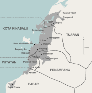
Greater Kota Kinabalu refers to the urbanised areas surrounding the city of Kota Kinabalu in Malaysia. Kota Kinabalu is the capital of the state of Sabah and is the largest city in the state. The contiguous built-up urban agglomeration around Kota Kinabalu extends beyond the city boundary on the south side and into the district of Penampang.[3][4] and to a lesser but growing extent into the districts of Papar (south) and Tuaran (north).
The term Greater Kota Kinabalu is normally used by the state and federal government in relation to social and economic development planning and strategy such as the Sabah Integrated Coastal Zone Management,[5] Sabah Economic Development and Investment Authority,[3] Sabah Town and Regional Planning Department.[6] and the Greater Kota Kinabalu Flood Prevention Committee.[4]
Greater Kota Kinabalu is sometimes referred to as Kota Kinabalu Urban Area, Conurbation of Kota Kinabalu or Kota Kinabalu Metropolitan Area. Kota Kinabalu Metropolitan Area may also include the towns and districts of Papar 38 km south and Tuaran 34 km north of Kota Kinabalu being satellite towns within the metropolitan area.[7]
The population of Greater Kota Kinabalu is 629,943[3] and Kota Kinabalu Metropolitan Area (including Papar and Tuaran) is 837,694.[7] The population of the city/district of Kota Kinabalu is 462,963.[8] Greater Kota Kinabalu ranks among the six largest conurbation in Malaysia together with Kuala Lumpur (Klang Valley), Greater Penang, Johor Bahru, Ipoh and Kuching.[9] A government investment promotion body estimates the population of Greater KK to be 900,000.[10]
The economic center and focus point of Kota Kinabalu is a small area by the coast known as the Kota Kinabalu Central Business District or Kota Kinabalu City Center.
Geography
Kota Kinabalu lies on the west coast of Sabah (northwest of Borneo) facing South China Sea. There is only a narrow plain between the sea and Crocker Range throughout most of the western coast of Sabah. The development is thus concentrated along the coast towards the north and south of Kota Kinabalu.
Population
The population of Greater Kota Kinabalu is 629,943,[3] which includes Kota Kinabalu, Putatan and Penampang. If Tuaran and Papar are included, the population is 837,694 (Metropolitan).[7] All five districts in the region together with the districts of Kota Belud and Ranau are within the West Coast Division of Sabah. The following is the total population by administrative districts based on the official 2010 national census.[8]
| District | Population | Area (km²) | Density (people/km²) |
|---|---|---|---|
| Kota Kinabalu | 462,963 | 351 | 1,319 |
| Penampang including Putatan sub-district | 125,193 | 411 | 305 |
| Papar | 128,434 | 1,243 | 103 |
| Tuaran including Tamparuli sub-district | 105,435 | 1,166 | 90 |
| Ranau | 95,800 | 3,608 | 27 |
| Kota Belud | 93,180 | 1,386 | 67 |
| Greater KK (KK + Penampang) | 644,020 | 816 | 789 |
| Metro (GKK + Tuaran and Papar) | 877,889 | 3,225 | 272 |
| West Coast Division | 1,067,589 | 7,588 | 140 |
Major towns and built-up areas
Within city district
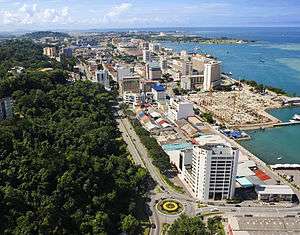
- Kota Kinabalu CBD
- Karamunsing
- Api-Api
- Asia City
- Bandaran Berjaya
- Kampung Air
- Sinsuran
- Segama
- Gaya Street
- KK Lama (Old Town)
- KK Jetty (Jesselton Point)
- KK Port
- Tanjung Aru
- Sutera Harbour
- Sembulan
- Luyang
- Lintas
- Lido
- Kepayan
- Likas
- Kolombong
- Inanam
- Menggatal
- Alam Mesra
- Sepanggar
- Sepanggar Port
- Telipok
Outside city district but within urban area
- Penampang (District)
- Donggongon
- Bandar Penampang Baru (Koidupan-Noosob/Kepayan Ridge-Lido)
- Lok Kawi
- Putatan
- Petagas
- Bundusan
- Papar (District)
- Tuaran (District)
Outside urban area but within metropolitan area
Administration
There are 3 local government administrating GKK area:
- Kota Kinabalu City Hall
- Penampang District Council
- Tuaran District Council
References
- ↑ "Administration Structure". Sabah Lands and Surveys Department. Retrieved 18 May 2012.
- ↑ "Kota Kinabalu". Google Search. Google Maps. Retrieved 18 May 2012.
- 1 2 3 4 "Greater Kota Kinabalu Healthcare Overview" (PDF). Sabah Economic Development and Investment Authority (SEDIA). Retrieved 19 April 2012.
- 1 2 "Three strategies to solve flooding in KK". Borneo Post Online. 29 March 2012. Retrieved 23 April 2012.
- ↑ "Homepage for the ICZM unit in Sabah". Sabah Integrated Coastal Zone Management. Retrieved 19 April 2012.
- ↑ "Main Page". Sabah Town and Regional Planning Department. Retrieved 19 April 2012.
- 1 2 3 S. C. Cheah (14 March 2005). "Property Talk: KK Turning Into Shopping Haven". The Star (Malaysia).
- 1 2 "Population Distribution and Basic Demographic Characteristics, 2010" (PDF). Department of Statistics, Malaysia. Retrieved 19 April 2012.
- ↑ "Malaysia: Federal States, Territories, Major Cities & Conurbations - Statistics & Maps on City Population". City Population. Retrieved 25 May 2012.
- ↑ "Greater Kota Kinabalu (Greater KK)". myCorridor: Official Investment Gateway. 8 November 2013. Retrieved 25 April 2014.
| Districts | |
|---|---|
| Neighbourhoods and Townships |
|
| Towns | |
Zone or Special Area in Sabah | ||
|---|---|---|
| Security |
| |
| Economics and Development | ||
Coordinates: 5°58′36″N 116°05′31″E / 5.97668°N 116.09184°E