Great Storm of 1987
| The Great Storm of 1987 | |
|---|---|
 | |
| Data | |
| Formed: | 15 October 1987 |
| Dissipated: | 16 October 1987 |
| Lowest pressure: | 953 mbar (hPa)[1] |
| Highest winds: | 216 km/h (134 mph)[1] |
| Countries affected | |
| Fatalities: | 22 |
| Damage: | UK: £2 billion (£5.073 billion today) France: 23 billion francs (£7.027 billion today) |
The Great Storm of 1987 was a violent extratropical cyclone that occurred on the night of 15–16 October, with hurricane-force winds causing casualties in England, France and the Channel Islands as a severe depression in the Bay of Biscay moved northeast. Among the most damaged areas were Greater London, the East Anglian coast, the Home Counties, the west of Brittany and the Cotentin Peninsula of Normandy which weathered gusts typically with a return period of 1 in 200 years.[2][3]
Forests, parks, roads and railways were strewn with fallen trees as well as schools being closed. The British National Grid suffered heavy damage, leaving thousands without power. At least 22 people were killed in England and France.[4] The highest measured gust of 117 kn (217 km/h; 135 mph) was recorded at Pointe Du Roc, Granville, France and the highest gust in the U.K. of 100 kn (190 km/h; 120 mph) was recorded at Shoreham-by-Sea [5]
That day's weather reports had failed to indicate a storm of such severity, an earlier, correct forecast having been negated by later projections. The apparent suggestion by the BBC's Michael Fish of a false alarm is celebrated as a classic gaffe, though he claims he was misquoted.[6]
Major improvements were later implemented in atmospheric observation, relevant computer models, and the training of forecasters.[7]
Development

On the Sunday before the storm struck, the farmers' forecast had predicted bad weather on the following Thursday or Friday, 15–16 October.[8] By midweek, however, guidance from weather prediction models was somewhat equivocal. Instead of stormy weather over a considerable part of the UK, the models suggested that severe weather would reach no farther north than the English Channel and coastal parts of southern England.[8]
During the afternoon of 15 October, winds were very light over most parts of the UK. The pressure gradient was slack. A depression was drifting slowly northwards over the North Sea off eastern Scotland. A trough lay over England, Wales and Ireland. Over the Bay of Biscay, a depression was developing.[9]
First warnings
The first gale warnings for sea areas in the English Channel were issued at 0630 UTC on 15 October and were followed, four hours later, by warnings of severe gales. At 1200 UTC on 15 October, the depression which originated in the Bay of Biscay was centred near 46° N, 9° W and its depth was 970 mb. By 1800 UTC, it had moved north-east to about 47° N, 6° W, and deepened to 964 mb.
At 2235 UTC, winds of Force 10 were forecast. By midnight, the depression was over the western English Channel, and its central pressure was 953 mb. At 0140 on 16 October, warnings of Force 11 were issued. The depression now moved rapidly north-east, filling a little as it did, reaching the Humber estuary at about 0530 UTC, by which time its central pressure was 959 mb. Dramatic increases in temperature were associated with the passage of the storm's warm front.
It is now clear that for sea areas, warnings of severe weather were both timely and adequate, although forecasts for land areas left much to be desired. During the evening of 15 October, radio and TV forecasts mentioned strong winds, but indicated that heavy rain would be the main feature, rather than wind. By the time most people went to bed, exceptionally strong winds had not been mentioned in national radio and TV weather broadcasts.
Warnings of severe weather had been issued, however, to various agencies and emergency authorities, including the London Fire Brigade. Perhaps the most important warning was issued by the Met Office to the Ministry of Defence (MoD) at 0135 UTC, 16 October. It warned that the anticipated consequences of the storm were such that civil authorities might need to call on assistance from the military.
Winds

A highest gust of 119 kn (220 km/h; 137 mph) is estimated from satellite data at Quimper, Brittany, with the highest measured gust at 117 kn (217 km/h; 135 mph) at Pointe du Roc, Granville Normandy.[4]
In south-east England, where the greatest damage occurred, gusts of 70 knots (130 km/h; 81 mph) or more were recorded continually for three or four consecutive hours. During this time, the wind veered from southerly to south-westerly. To the north-west of this region, there were two maxima in gust speeds, separated by a period of lower wind speeds. During the first period, the wind direction was southerly. During the latter, it was south-westerly. Damage patterns in south-east England suggested that tornadoes accompanied the storm.
In the UK, winds at Shoreham-by-Sea, Sussex reached 100 kn (190 km/h; 120 mph) before the anemometer failed.[4][10][11] Many anemometers were reliant on mains power, and ceased recording as the south east of the United Kingdom was blacked-out by power cuts, thus losing much valuable data.[9] Winds with an estimated 200-year return period hit the counties of Kent, Sussex, Hampshire and along the coastal strip of Essex, Suffolk and South Eastern Norfolk.[9] North of a line from Portland Bill, Dorset to Cromer, Norfolk the return period of the respective gusts were under 10 years.[9]
According to the Beaufort scale of wind intensities, this storm had winds of hurricane force 12; as the term hurricane refers to tropical cyclones originating in the North Atlantic or North Pacific, the accurate descriptor for the storm is "great storm", which has tended to be reserved for only those storms in recent years reaching this velocity. Hurricanes have a very different wind profile and distribution from storms, and significantly higher precipitation levels. However to those affected in South-East England, it became known simply as The Hurricane and immortalised in Bob Ogley's book "In the Wake of The Hurricane" (ISBN: 9780951301906).
| 0 | 1 | 2 | 3 | 4 | 5 | 6 | 7 | 8 | 9 | 10 | 11 | 12 |
|---|---|---|---|---|---|---|---|---|---|---|---|---|
| Calm | Light Air | Light Breeze | Gentle Breeze | Moderate Breeze | Fresh Breeze | Strong Breeze | Near Gale | Gale | Strong Gale | Storm | Violent Storm | Hurricane Force |
| Light Winds | High Winds | Gale-force | Storm-force | Hurricane-force | ||||||||
| <1 mph <1 knot <0.3 m/s |
1–3 mph 1–3 knots 0.3–1.5 m/s |
4–7 mph 4–6 knots 1.6–3.3 m/s |
8–12 mph 7–10 knots 3.4–5.5 m/s |
13–18 mph 11–16 knots 5.5–7.9 m/s |
18–24 mph 17–21 knots 8.0–10.7 m/s |
25–31 mph 22–27 knots 10.8–13.8 m/s |
31–38 mph 28–33 knots 13.9–17.1 m/s |
39–46 mph 34–40 knots 17.2–20.7 m/s |
47-54 mph 41–47 knots 20.8–24.4 m/s |
55–63 mph 48–55 knots 24.5–28.4 m/s |
64–72 mph 56–63 knots 28.5–32.6 m/s |
≥73 mph ≥63 knots ≥32.7 m/s |
Impact
United Kingdom
The storm made landfall in Cornwall, before tracking north-east towards Devon and then over the Midlands, going out to sea via The Wash. The strongest gusts, of up to 100 knots (190 km/h; 120 mph), were recorded along the south-eastern edge of the storm, hitting mainly Hampshire, Sussex, Essex and Kent. The Royal Sovereign lighthouse 6 miles (9.7 km) off Eastbourne recorded wind speeds on their instruments pegged at 110 mph offscale high, i.e. could read no higher.
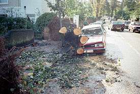
The storm caused substantial damage over much of England, felling an estimated 15 million trees[12] (including six of the seven eponymous oaks in Sevenoaks,[13] historic specimens in Kew Gardens, Wakehurst Place, Nymans Garden, Hyde Park, London and Scotney Castle[14] and most of the trees making up Chanctonbury Ring). At Bedgebury National Pinetum, Kent almost a quarter of the trees were brought down.[15][16] There have been many claims that the damage to forestry was exacerbated by broadleaf trees still being in leaf at the time of the storm, though this was not borne out by an analysis by the Forestry Commission.[17]
Fallen trees blocked roads and railways and left widespread structural damage primarily to windows and roofs. Several hundred thousand people were left without power, not fully restored until more than two weeks later. Local electric utility officials later said they lost more wires in the storm than in the preceding decade. At sea, as well as many small boats being wrecked, a Sealink cross-channel ferry, the MV Hengist, was driven ashore at Folkestone and the bulk carrier MV Sumnea capsized at Dover, Kent.[18]
The National Grid sustained heavy damage during the event, as crashing cables short-circuited, which in some cases overheated the main system. Its headquarters faced the choice of keeping the Grid online to help London as the storm approached but risk an incremental system breakdown, failure and burnout, or to shut down most of South East England including London and avert that risk. The headquarters made the decision, the first one like it since before World War II: to shut down the South East power systems to maintain the network as soon as signs of overheating began.
In London, many of the trees lining streets were blown down overnight, particularly plane trees, blocking roads and crushing parked cars. Building construction scaffolding and billboards had collapsed in many places, and many buildings were damaged. The following morning, the BBC's largest broadcasting site, Lime Grove Centre in White City was unable to function due to a power failure — ITV's TV-am and BBC1's Breakfast Time programmes were broadcast from markedly different emergency facilities (TV-am broadcast from Thames Television's Euston Road studios, while BBC newsreader Nicholas Witchell had to broadcast from the BBC1 continuity studio at BBC Television Centre, with the wall decorations used for Children's BBC hastily taken down), on emergency formats. Much of the public transport in the capital was not functioning, and people were advised against trying to go to work.
France
The départements of Finistère, Morbihan, Côtes-d'Armor and Ille-et-Vilaine in Brittany, and the Cotentin Peninsula (Manche and part of Calvados) in Normandy were the areas in France most affected by the storm, which followed a line from Morbihan and Rennes to Deauville.[19] 1.79 million homes were left without electricity supply and water, and a quarter of Brittany's forest was destroyed. The total damage was estimated at ₣23 billion.
Météo France announced "une petite tempête en provenance des Açores" (a little storm coming in from the Azores), which reached Brittany's coast at about 6 p.m., later than expected. This depression caused little damage, with only 50 to 60 km/h (31 to 37 mph; 27 to 32 kn) winds. A much deeper depression hit Ushant on the extreme western tip of Brittany at midnight. It was measured at 948 hPa (or 948 mb) at the Brest-Guipavas weather station, the lowest reading in its records, that began with its opening in 1945.[19]
Weather stations on the coast at pointe du Raz, pointe Saint-Mathieu and Penmarch gave no readings, as they were damaged by the high winds. The wind speed measured at Brest was 148 km/h (92 mph; 80 kn). The centre of the storm crossed Brittany from Penmarch to Saint-Brieuc at 110 km/h (68 mph; 59 kn), with gusts of wind up to 187 km/h (116 mph; 101 kn) at Quimper, 200 km/h (120 mph; 110 kn) at Ouessant and 220 km/h (140 mph; 120 kn) at la pointe de Penmarch and Granville. Waves were measured at 16 m (52 ft) off Ushant and Belle Île.[19]
Similar strength storms in France since 1960:
- Tempête Vivian in 1990 (generally milder)
- Cyclone Lothar and Martin in December 1999, which claimed 140 lives, equally severe in Germany, more southern neighbouring countries also saw multiple deaths.
- Cyclone Klaus which struck worse southern France and northern Spain in 2009 and claimed 26 lives.
The church at Concarneau was damaged but never rebuilt, and was finally demolished a few years later.

The MS Herald of Free Enterprise was caught in the storm off Cape Finisterre as it was making its way for scrapping in Taiwan. The ship was cast adrift after its tow rope parted, finally resuming its journey on 19 October 1987.[20]
Aftermath
The storm cost the insurance industry £2bn, making it the second most expensive UK weather event on record to insurers after the Burns' Day storm of 1990.[21] Peak wind velocities were in the early hours of the morning, which may have helped reduce the death toll. The storm hit the Isle of Wight at 2 a.m., and Shanklin Pier on the south-east coast of the Island was broken into three pieces as a result of mountainous waves. Plans to rebuild the pier were soon abandoned, and the rest of the pier was demolished by contractors shortly afterwards. A monument now stands in front of what used to be the pier entrance.
A great deal of effort and money was put into the post-storm clean-up of forests and wooded areas. The writer Oliver Rackham and the charity Common Ground, were active in trying to prevent unnecessary destruction of trees which, although fallen, were still living.[22][23] Some landowners, such as the National Trust, did not attempt complete clearing and replanting, realising that there was a unique opportunity to study the patterns of natural regeneration after such an event.[24]
A number of wild boar may have escaped from captivity during the storm, after enclosures were damaged by falling trees. These boar have since bred and established populations in woods across southern England.[25]
A more positive aspect could be found among some British gardeners; as Heather Angell wrote in the Royal Horticultural Society's Journal:
In some places this natural disaster has resulted in splendid vistas- views long since forgotten by some and never before seen by a whole new generation. Because of gaps left by fallen trees, visitors to Arundel Castle, the ancestral home of the Dukes of Norfolk, can now look out over the picturesque town... At the renowned woodland rhododendron garden at Leonardslee, Sussex, the gale... opened magnificent views by removing about a thousand trees which owner Robin Loder said he would never have had the courage to thin out himself.[26]
Following the storm meteorologists at the University of Reading led by Professor Keith Browning developed the Sting jet concept. During reanalysis of the storm they identified a mesoscale flow where the most damaging winds were shown to be emanating from the evaporating tip of the hooked cloud head on the southern flank of the cyclone. This cloud, hooked like a scorpion's tail, gives the wind region its name the "Sting Jet".[10][27]
Criticism of the Met Office
The Met Office was severely criticised by most of the national press for failing to forecast the storm correctly.[8]
The Met Office conducted an internal inquiry, scrutinised by two independent assessors, and a number of recommendations were made. Chiefly, observational coverage of the atmosphere over the ocean to the south and west of the UK was improved by increasing the quality and quantity of observations from ships, aircraft, buoys and satellites. Continued refinements were made to the computer models used in forecasting, and changes were made in the training of forecasters. In addition, reforms in the way the Met Office reports warnings of severe weather were implemented, leading to substantially more warnings being issued in the future. Further deployment of improved tracking devices and improvements in the computer model simulations were supported by the purchase of an additional Cray supercomputer. Warnings for the Burns' Day storm just over two years later were accurate and on time, although the model forecast hinged on observations from two ships in the Atlantic near the developing storm the day before it reached the UK.[28]

BBC meteorologist Michael Fish drew particular criticism for reporting several hours before the storm hit:
"Earlier on today, apparently, a woman rang the BBC and said she heard there was a hurricane on the way; well, if you're watching, don't worry, there isn't, but having said that, actually, the weather will become very windy, but most of the strong winds, incidentally, will be down over Spain and across into France."[29]
Fish has subsequently claimed that his comments about a hurricane had nothing to do with the UK; they referred to Florida, USA, and were linked to a news story immediately preceding the weather bulletin, but had been so widely repeated out of context that the British public remains convinced that he was referring to the approaching storm. According to Fish, the woman in question was actually a colleague's mother who was about to go on holiday in the Caribbean, and had called regarding (the already long-dissipated) Hurricane Floyd to see if it would be safe to travel.[30] Fish has also claimed that "nobody phoned up" and that she was a "non-existing woman", apparently contradicting the previous declaration, when interviewed about Anita Hart's claims of being the woman who made the call.[31]
Fish went on to warn viewers that it would be "very windy" across the south of England, but predicted that the storm would move further south along the English Channel and the British mainland would escape the worst effects. The remainder of his warning is frequently left out of re-runs, which only adds to the public's misconception of that day's forecasting. His analysis has been defended by weather experts. In particular, the lack of a weather ship in the Southwest Approaches, due to Met Office cutbacks,[32] meant the only manner of tracking the storm was by using satellite data, as automatic buoys had not been deployed at the time.
Ironically, earlier forecasts as far back as the preceding weekend had correctly identified that gale force winds would affect Southern England. However, later runs of the model had indicated a more southerly track for the low pressure system, incorrectly indicating that the strongest winds would be confined to Northern and Central France. The French meteorological office used a different computer weather model to the British, and the French model proved more accurate in predicting the severity of the storm in the Channel.
In the wake of the storm the Met Office set up the National Severe Weather Warning Service.[7]
Climatological context
It is claimed this storm was the worst since the Great Storm of 1703,[7][33][34] which has been challenged as a myth.[2][3] Storms of this strength regularly form over the North Atlantic, where they typically track to the north of Scotland. Storms of such a strength have a return period of 30 to 40 years.[4] The unusual aspect of the storm was that it struck the densely populated southeast of England.[2][3] That winds in the South East had return periods of 1 in 200 years does not mean the winds of this strength occur on average once every 200 years, but that the winds have a 0.5% probability of happening in a given year.[Note 1]
Following this storm 1.3 million incidents of damage were reported, which is only exceeded by the Gale of January 1976 where destruction covered a wider area of the U.K., with 1.5 million incidents of damage reported.[1] The Burns' Day storm hit the United Kingdom in January 1990, less than three years later and with comparable intensity.
Wider impacts
Black Monday
Following the storm few dealers made it to their desks and stock market trading was suspended twice and the market closed early at 12.30pm. The disruption meant the City was unable to respond to the late dealings at the beginning of the Wall Street fall-out on Friday 16 October, when the Dow Jones Industrial Average recorded its biggest ever one day slide at the time, a fall of 108.36. City traders and investors spent the weekend, 17–18 October, repairing damaged gardens in between trying to guess market reaction and assessing the damage.[35] October 19, Black Monday, was memorable as being the first business day of the London markets after the Great Storm.
Cultural references
- The storm features in an important scene near the end of Possession: A Romance, the Man Booker Prize-winning novel by A. S. Byatt.
- The novelist W. G. Sebald recalls the storm towards the end of The Rings of Saturn, as he is visiting Ditchingham Hall in Norfolk, where the storm did great damage to estate trees.
- The BBC drama Our Friends in the North features a character, Eddie Wells MP, dying of a heart attack as the storm hits Westminster.
- Richard Poole repeatedly mentions the storm in the Death in Paradise episode "A Stormy Occurrence".[36]
- Michael Fish's controversial weather forecast featured in the London 2012 Summer Olympics opening ceremony,[6] playing on the perceived British love of talking about the weather.
See also
Notes
References
- 1 2 3 United Kingdom Met Office (2007). "The Great Storm of 1987" (PDF). Risk Management Solutions. Retrieved 2 August 2009.
- 1 2 3 Vidal, John (16 October 2012). "Sting jet technology means no more hurricane mishaps for Michael Fish". The Guardian. Retrieved 8 December 2012.
- 1 2 3 "How did the 'Great Storm' of 1987 develop?". Met Office News Blog. 10 October 2012. Retrieved 8 December 2012.
- 1 2 3 4 "The Great Storm of 1987". Wayback Machine: Met Office. Archived from the original on 7 September 2008. Retrieved 6 January 2013.
- ↑ http://www.metoffice.gov.uk/learning/learn-about-the-weather/weather-phenomena/case-studies/great-storm
- 1 2 "Great Storm of 1987: Michael Fish's 'white lie'". BBC News. 15 October 2012. Retrieved 8 December 2012.
- 1 2 3 "Lessons learned from Great Storm". BBC News. 14 October 2007. Retrieved 4 May 2010.
- 1 2 3 Houghton, J. T. "The Storm, The Media and the Enquiry". Weather. 43: 67–70. Bibcode:1988Wthr...43...67H. doi:10.1002/j.1477-8696.1988.tb03883.x. Retrieved 9 February 2013.
- 1 2 3 4 Burt, S. D.; Mansfield, D. A. (1988). "The Great Storm of 15–16 October 1987". Weather. 43 (3): 90–108. Bibcode:1988Wthr...43...90B. doi:10.1002/j.1477-8696.1988.tb03885.x. Retrieved 6 January 2013.
- 1 2 "The 1987 Great Storm – What is a Sting Jet?". Met Office. Retrieved 27 February 2013.
- ↑ "The Sting Jet Forecasting the damaging winds in European Cyclones" (PDF). Met Office. Retrieved 27 February 2013.
- ↑ Richardson, Tim (12 October 2007). "The Great Storm of 1987 remembered". Daily Telegraph. Retrieved 6 May 2010.
- ↑ "A brief history of Sevenoaks Town". History of Sevenoaks. Sevenoaks Life. Retrieved 28 July 2008.
- ↑ These much-visited gardens were noted in an editorial in Horticulture: The Magazine of American Gardening, November 1988:13.
- ↑ "Summary of the Bedgebury Forest archaeological survey". Bedgebury Forest archaeological survey. Forestry Commission. Retrieved 2009-10-01.
- ↑ "History of Bedgebury National Pinetum". Forestry Commission. Retrieved 2009-10-01.
- ↑ Quine, C. P. (March 1988). "DAMAGE TO TREES AND WOODLANDS IN THE STORM OF 15-16 OCTOBER 1987". Weather. 43 (3): 114–118. Bibcode:1988Wthr...43..114Q. doi:10.1002/j.1477-8696.1988.tb03888.x.
- ↑ Tony Dawe, Robert Matthews and Nicholas Wood (17 October 1987). "Wasted warning of the storm". The Times (62902). London. col A-H, p. 1.
- 1 2 3 "L'Ouest balayé par un ouragan dévastateur (the West swept up by a devastating hurricane)" (in French). Météo France (government organisation).
- ↑ Gripper, Ann (25 October 2013). "UK weather: A look back at the devastating Great Storm of 1987 that nobody predicted". Daily Mirror. Retrieved 30 May 2015.
- ↑ "UK storm payout 'may hit £350m'". BBC News. bbc.co.uk. 20 February 2007. Retrieved 20 February 2007.
The 'great storm' of 1987, which cost the industry £2bn, was the second most expensive.
- ↑ Watkins, Jack (13 October 2007). "1987 Great Storm: Terrible blow, not a knockout". The Daily Telegraph. London. Retrieved 4 May 2010.
- ↑ Oliver Rackham, Trees & Woodland in the British Landscape p. 202–3 (Dent, 1990)
- ↑ see e.g. http://www.telegraph.co.uk/earth/3310333/1987-Great-Storm-Terrible-blow-not-a-knockout.html
- ↑ Britten, Nick (17 Mar 2004). "Wild boar back from extinction". The Telegraph. Retrieved 1 August 2012.
- ↑ Angel, in The Garden: Journal of the Royal Horticulyural Society, March–April 1988.
- ↑ Browning, Keith; Peter Clark; Tim Hewson; Robert Muir-Wood (2003). "Damaging winds from European cyclones". The Royal Society. Retrieved 27 March 2013.
- ↑ Heming, J.T. (1990). "The impact of surface and radiosonde observations from two Atlantic ships on a numerical weather prediction model forecast for the storm of 25 January 1990.". The Meteorological Magazine. 119: 249–259.
- ↑ YouTube footage of Michael Fish
- ↑ "Michael Fish and the 1987 Storm". BBC Weather. www.bbc.co.uk. Retrieved 2007-02-20.
- ↑ TVinsiderV. "BBC weather Michael Fish mystery phone caller revealed 1987". YouTube. Retrieved 2012-01-21.
- ↑ "Romeo Would Have Spied the Storm". New Scientist. IPC Magazines. 116 (1583): 22. 1987-10-22. Retrieved 2011-01-18.
- ↑ "Factfile: The 1987 Great Storm". Anglia – ITV News. 15 October 2012. Retrieved 8 December 2012.
- ↑ "Factfile: The 1987 Great Storm". Met Office. Retrieved 8 December 2012.
- ↑ Gribben, Roland (18 October 2012). "Black Monday taught salutary lessons all round". The Telegraph. Retrieved 17 April 2013.
- ↑ Simon, Jane (19 February 2013). "Tuesday's must-see TV: Not even a hurricane in the Caribbean can ruffle DI Richard Poole's stiff upper lip in Death in Paradise". Daily Mirror. Retrieved 3 September 2015.
- ↑ "Engineering Misconceptions, Part 1 - Return Periods". Ronjie.com Civil Engineering Blog. Retrieved 4 November 2013.
External links
| Wikimedia Commons has media related to Great Storm of 1987. |
- Met Office report
- BBC news report, On This Day, including video
- Details of the damage in France (French)
- Useful maps of the storm (French)
- Teachers TV, Great Storm 1987
| Historical |  | |
|---|---|---|
| 1900s |
| |
| 2000s | ||
| 2015– Name our Storms | ||
| See also | ||