Great Ruaha River

The Great Ruaha River is a river in south-central Tanzania that flows through the Usangu wetlands and the Ruaha National Park east into the Rufiji River. Its basin catchment area is 83,970 square kilometres (32,421 sq mi).[1] The population of the basin is mainly sustained by irrigation and water-related livelihoods such as fishing and livestock keeping.
Great Ruaha is about 475 km (300 mi.) long, its tributary basin has a catchment area of 68,000 km² and the mean annual discharge is 140 m³/s. The Great Ruaha River supplies 22 per cent of the total flow of the Rufiji catchment system. Thirty-eight species of fish have been identified in the Great Ruaha River.
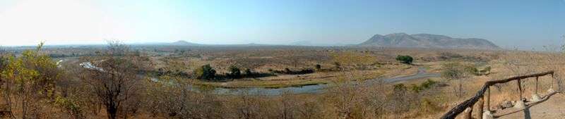
The river's headwaters are in the Kipengere Range. From there the Great Ruaha River descends to the Usangu plains, an important region for irrigated agriculture and livestock in Tanzania. The river eventually reaches the Mtera Dam and then flows south to the Kidatu Dam. These two generate about 50 per cent of the Tanzania's electricity. The river continues southwards and flows across the Selous Game Reserve before reaching the Rufiji River. The major rivers contributing to the Great Ruaha River are Lukosi, Yovi, Kitete, Sanje, Little Ruaha, Kisigo, Mbarali, Kimani and Chimala whereas the small ones include Umrobo, Mkoji, Lunwa, Mlomboji, Ipatagwa, Mambi and Mswiswi rivers.
Decreased flows in the Great Ruaha have been recorded since the early 1990s, resulting in complete drying of sections of the river in 1993 and in dry years since (illustration above). This has been attributed to uncontrolled and poor water management, with the large rice irrigation schemes playing a major role.
References
- ↑ Arvidson, Anders; et al. (May 2009). "Initial Assessment of Socioeconomic and Environmental Risks and Opportunities of Large‐scale Biofuels Production in the Rufiji District" (PDF). SEKAB BioEnergy (T) Ltd. p. 23.
Sources
- WWF.org - The Ruaha Water Programme
- Ruaha information with images
- FAO review
- FAO - fact sheet on the ecohydrology of the Great Ruaha River (2003)
Öhman, May-Britt, Taming Exotic Beauties: Swedish Hydro Power Constructions in Tanzania in the Era of Development Assistance, 1960s - 1990s, Stockholm, 2007, PhD Thesis, http://www.diva-portal.org/smash/record.jsf?pid=diva2:12267
Coordinates: 7°56′S 37°52′E / 7.933°S 37.867°E