Great Falls (Missouri River waterfall)
| Great Falls | |
|---|---|
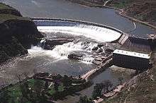 Great Falls and Ryan Dam | |
 Map of Montana | |
| Location | Near Great Falls, Montana |
| Coordinates | 47°34′07″N 111°07′27″W / 47.56862°N 111.1241°WCoordinates: 47°34′07″N 111°07′27″W / 47.56862°N 111.1241°W |
| Type | Segmented block |
| Total height | 87 ft (27 m) |
| Number of drops | 1 |
| Total width | 900 ft (270 m) |
| Watercourse | Missouri River |
| Average flow rate | 8,500 cu ft/s (240 m3/s) |
Great Falls (also called Grand Falls or Big Falls[1]) is a major waterfall located on the Missouri River in western Montana in the United States. It is the lowermost and largest of the eponymous Great Falls of the Missouri, at 87 feet (27 m) high and up to 900 feet (270 m) wide at peak flow. Although the falls used to flow powerfully year-round, most of the water is now diverted to the 60 megawatt hydroelectric plant of upstream Ryan Dam, reducing it to a trickle in the summer months.[2] Grand Falls was named by William Clark of the Lewis and Clark Expedition in 1805.
References
- ↑ "Great Falls of the Missouri". Montana Bureau of Mines and Geology. Retrieved 2012-01-14.
- ↑ "Ryan Dam". Producing Power. pplmontana.com. Retrieved 2011-01-14.
This article is issued from Wikipedia - version of the 10/18/2014. The text is available under the Creative Commons Attribution/Share Alike but additional terms may apply for the media files.