Great Divide Basin
| Great Divide Basin | |
| Drainage basin | |
 The Great Divide Basin is an endorheic drainage basin on the Continental Divide in the United States. | |
| Country | United States |
|---|---|
| State | Wyoming |
| Region | Red Desert |
| Part of | Wyoming Basin physiographic province |
| Location | Sweetwater, Carbon, Fremont counties |
| - elevation | 6,500 ft (2,000 m) [1] |
| - coordinates | 41°0′01″N 107°59′2″W / 41.00028°N 107.98389°WCoordinates: 41°0′01″N 107°59′2″W / 41.00028°N 107.98389°W |
| Area | 3,959 sq mi (10,253.8 km2) [2] |
| Geology | Marine Upper Cretaceous rocks, continental early Paleogene rocks, lacustrine rocks Eocene (Green River Formation)[3] |
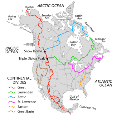
The Great Divide Basin or Great Divide Closed Basin[4] is an area of land in Wyoming's Red Desert (United States) where none of the water falling as rain to the ground drains into any ocean, directly or indirectly. It is therefore considered an endorheic basin, and it adjoins the Continental Divide in southern Wyoming. To the west of the basin is the Green River watershed, draining to the Gulf of California/Pacific Ocean; to the east is the North Platte watershed, draining to the Gulf of Mexico/Atlantic Ocean. The basin is very roughly rectangular in shape; the northwest corner is in the Wind River Range near South Pass, about 40 miles southwest of Lander, and the southeast corner is in the Sierra Madre Range near Bridger Pass, about 20 miles southwest of Rawlins.[3]
Although the Great Divide Basin provides a relatively low and easy crossing of the Continental Divide, its aridity and endorheic nature were an obstacle to pioneers during the westward expansion of the United States, and was known as the Saline Plain around the 1870s.[5] Consequently, the Oregon Trail detoured north over South Pass, and the Overland Trail detoured south over Bridger Pass. By contrast, during the construction of the first transcontinental railroad, the Union Pacific was laid directly across the southern part of the basin. (The original railroad map labelled one point along this route as Bridgers Pass,[6] giving rise to the still-common misconception that the railroad followed the Overland Trail.) Roughly the same route across the basin was later taken by the transcontinental highways traversing the region, namely the Lincoln Highway, U.S. 30, and Interstate 80. The basin is also traversed in a north-south direction by U.S. 287 and Wyoming 789. Even today the basin is very sparsely populated, the only incorporated town being Wamsutter, with a population of 451 at the 2010 census.

A westward traveler on Interstate 80 crosses from the Gulf of Mexico drainage to the Great Divide Basin at about 41°47′17″N 107°22′34″W / 41.788°N 107.376°W, roughly 7 miles west of Rawlins. A highway sign marks this as a crossing of the Continental Divide, although that is a matter of interpretation. At about 41°42′58″N 107°46′55″W / 41.716°N 107.782°W is the exit for Continental Divide Road, the highest point on I-80 within the Great Divide Basin, at an elevation of 7,130 ft (2,170 m).[7] While this is no longer recognized as a crossing of the Divide, it was evidently considered to be just that during the days of the Lincoln Highway and U.S. 30, and a monument to Henry B. Joy, the first president of the Lincoln Highway Association, was placed just south of this point along the old highway. (It was relocated to Sherman Summit in 2001 to protect it from increasing vandalism.) Further west, I-80 crosses to the Colorado River drainage at about 41°37′52″N 108°18′40″W / 41.631°N 108.311°W. This is now recognized as the true location of the Continental Divide,[8] and at one time yet another highway sign could be found at this location. (The placement of the Divide along this ridge signifies that the otherwise endorheic basin would drain to the east if it were to overflow.) Having finally left the Great Divide Basin behind, I-80 continues west and at 41°16′30″N 110°48′07″W / 41.275°N 110.802°W enters the vastly larger Great Basin, staying within it until the crest of the Sierra Nevada at Donner Summit.
Geography
While usually thought of as a single basin, the Great Divide Basin is actually several contiguous sub-basins, most notably those centered on Circle Bar Lake, Frewen Lake, Lost Creek Lake, Red Lake, and Separation Lake. The interior ridges separating these sub-basins have led to disagreement about the correct path of the Continental Divide across or around the basin.
The Lucite Hills form part of the western boundary of the basin, featuring Black Rock Butte and Emmons Cone. Alkali Flat and Greasewood Flat are directly to their northeast. Sand dunes lie in the central western part of the basin. In the southern part of the western basin, Red Desert Flat and Red Desert Basin are the major features. These are about 25 miles (40 km) northwest of the town of Wamsutter. In the northeast part of the Great Divide Basin is Chain Lakes Flat, southwest and downslope from Bairoil and Lamont.[9]
The basin is a high desert dominated by sand dunes, bluffs and alkali flats. Flora and fauna include small trees in some ravines and the occasional shrub, along with many birds (e.g., sage grouse and pheasant) and pronghorn, mule deer, feral horses, and the occasional elk. The basin includes uranium ore deposits and many oil and natural gas wells.[10] There has been debate between those that wish to utilize the resources within the basin and those that wish to see at least parts of it officially designated as wilderness.[11]
References
- ↑ U.S. Geological Survey Geographic Names Information System: Great Divide Basin
- ↑ "Statewide Data Inventory - Green River/Great Divide Basin Introduction". Waterplan.state.wy.us. Retrieved 2008-12-05.
- 1 2 "Select Area of Interest". Wyoming Stratigraphy. Wyoming State Geological Survey. Retrieved 2010-04-24. External link in
|work=(help) (Great Basin Divide, Washakie Basin) - ↑ "Great Divide Closed Basin Watershed -- 14040200". Surf Your Watershed. United States Environmental Protection Agency. Retrieved 2010-04-24. External link in
|work=(help) - ↑ Nebraska, and the territories of Dakota, Idaho, Montana and Wyoming (Map). 1:3,000,000. Atlas of the United States. Cartography by H.F. Walling, O.W. Gray, and H.H. Lloyd & Co. Cincinnati: Stedman, Brown & Lyon. 1872.
- ↑ Wells, C.H. (December 7, 1867). "Profile of Pacific Railroad". Harper's Weekly.
- ↑ "Creston, Wyoming, 1966 USGS 7.5 minute topographic map via TopoQuest". USGS. Retrieved 2013-06-02.
- ↑ "Tipton, Wyoming, 1970 USGS 7.5 minute topographic map via TopoQuest". USGS. Retrieved 2013-06-02.
- ↑ Official State Highway Map of Wyoming (Map). Wyoming Department of Transportation. 2014.
- ↑ "Energy Metals Corporation Adds 5 Uranium Deposits And 39.5 Million Pounds In The Great Divide Basin, Wyoming". Marketwire.com. February 23, 2005. Retrieved 2008-12-05.
- ↑ "Showdown in the Great Divide". National Wildlife Federation. October 1, 2006. Retrieved 2013-12-10.