Great Colonnade at Apamea
 View of the colonnade | |
 Shown within Syria | |
| Location | Apamea, Syria |
|---|---|
| Coordinates | 35°25′02″N 36°24′05″E / 35.4173°N 36.4015°E |
| Type | Colonnade |
| Length | 2 kilometres (1.2 mi) |
| History | |
| Material | Limestone |
| Periods | Hellenistic, Roman, Byzantine |
| Site notes | |
| Condition | restored |
| Ownership | Public |
| Public access | Yes |
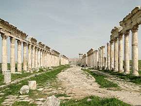
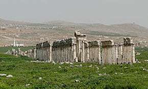
The Great Colonnade at Apamea was the main colonnaded avenue of the ancient city of Apamea in the Orontes River valley in northwestern Syria. It was built in the second century CE after Apamea's devastation in the 115 earthquake. The avenue, which ran for nearly 2 kilometres (1.2 mi), made up the city's north-south axis, or the cardo maximus. The monumental colonnade is among the longest and most famous in the Roman world.
Overview
The original Hellenistic colonnade was devastated, along with the rest of Apamea, in the 115 earthquake. Reconstruction started immediately under the Romans, and over the course of the second century the city was completely rebuilt, starting with the Great Colonnade.[1]
The colonnade was aligned along the north-south axis, making up the city's cardo maximus under the Romans. Starting at the city's north gate, the colonnade ran in an uninterrupted straight line for almost 2 kilometres (1.2 mi) to the south gate. The northern third of the colonnade's stretch is marked by a monumental votive column that stood opposite the baths.[2] The southern third, at around 1,500 metres (4,900 ft), is marked by the intersection with the city's main east-west axis, or the decumanus maximus. Two triple arches were built into the Great Colonnade as part of the intersection. The colonnade was further intersected by side streets at regular intervals of 110 metres (360 ft).[3] The colonnade passed through the center of the city and several important buildings were clustered around it, including the baths, the agora, the Temple of Tyche, the nymphaeum, the rotunda, the atrium church and the basilica.[4]
The street within the colonnade was 20.79 metres (68.2 ft) wide and paved with large polygonal limestone blocks. On either side of the street a 6.15 metres (20.2 ft) wide colonnade ran its full length. The columns were 9 metres (30 ft) high and 0.9 metres (2 ft 11 in) in diameter. They stood on square bases of 1.24 metres (4 ft 1 in) on a side and 0.47 metres (1 ft 7 in) high. The columns display two main designs: a plain one, and the distinctive spiral-flutes. Archaeologist Jean Lassus argues that the former dates back to the Trajanic period, while the latter to that of Antoninus Pius.[5] The colonnade's porticoes were paved with extensive mosaics along the full stretch of the colonnade.[2]
Under the Byzantine Emperor, Justinian I, several parts of the colonnade were restored. The street was narrowed to 12 metres (39 ft) by adding a sidewalk on either side. Several stretches of the street had their Roman pavement replaced with a new pavement made of squared blocks of limestone. The new pavement also covered a completely overhauled drainage system. Justinian's changes included erecting a monumental tetrastylon made up of four 9 metres (30 ft) high columns with a meter-high capitals.[6] The city, was however, later sacked by the Sasanians under Adarmahan.[7]
Gallery
-
Overview of the colonnade.
-

Columns decorated with the distinctive spiral-flutes.
-

The votive column standing opposite the baths.
-

Details of the capitals of the colonnade's columns.
-

A reconstruction of a section of the colonnade at the Cinquantenaire Museum in Brussels, Belgium
See also
Sources
Notes
Bibliography
- Balty, Jean Ch. (1988). "Apamea in Syria in the Second and Third Centuries A.D.". The Journal of Roman Studies. Society for the Promotion of Roman Studies. 78: 91–104. doi:10.2307/301452.
- Crawford, J. Stephens; Goodway, Martha (1990). The Byzantine Shops at Sardis. Harvard University Press. ISBN 9780674089686.
- Foss, Clive (1997). "Syria in Transition, A. D. 550-750: An Archaeological Approach". Dumbarton Oaks Papers. Dumbarton Oaks. 51: 189–269. doi:10.2307/1291765.