Great Blue Hill
| Great Blue Hill | |
|---|---|
 Great Blue Hill | |
| Highest point | |
| Elevation | 640+ ft (195+ m) [1] |
| Prominence | 483 ft (147 m) [1] |
| Coordinates | 42°12′43″N 71°06′56″W / 42.2120434°N 71.1156064°WCoordinates: 42°12′43″N 71°06′56″W / 42.2120434°N 71.1156064°W [2] |
| Geography | |
| Location | Norfolk County, Massachusetts |
| Parent range | Blue Hills |
| Topo map | USGS Norwood |
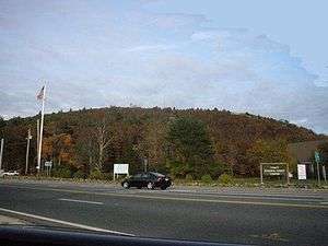
Great Blue Hill (called Massachusett by Native Americans) is a hill of 635 feet (194 m) located within the Blue Hills Reservation in Milton and Canton, Massachusetts 10 miles (15 km) southwest of downtown Boston. It is the highest point in Norfolk County. The modern name for the hill was given by early European explorers who, while sailing along the coastline, noticed the bluish hue of the exposed granite faces when viewed from a distance (due to Riebeckite). The Blue Hills's eastern slopes face the ocean and lie within Quincy. The area attracted quarrying for its "blue granite".[3] The name of the Massachusett Indian tribe and their language (and thus the name of the Bay, Colony, Commonwealth/State, etc.) derive from the Massachusett name for the hill: massa-adchu-es-et, where massa- is "large", -adchu- is "hill", -es- is a diminutive suffix meaning "small", and -et is a locative suffix, identifying a place.[4]
Geography
The north and west sides of Great Blue Hill drain into the Neponset River, and thence into Boston Harbor. The south and east sides of Great Blue Hill drain into the Blue Hill River, thence into the Farm River, Monatiquot River, Weymouth Fore River, and into Boston Harbor.
Its summit is the highest point in Norfolk County and also the highest within 10 miles of the Atlantic coast south of central Maine. For this reason, American meteorologist Abbott Lawrence Rotch chose Great Blue Hill as the site for an observatory, which became known as the Blue Hill Meteorological Observatory after its completion in 1885. Rotch conducted ground-breaking studies of the atmosphere at Blue Hill for many years, and meteorological data is still gathered at the site. From the Eliot Tower at the summit, the city of Boston and many of the surrounding hills of the Milton and Canton area are visible.
Other information
Great Blue Hill, and the Blue Hills Reservation in general, is a popular hiking destination, valued as much for its splendid trails and views as for its proximity to the metropolitan area. There is also alpine skiing available at Blue Hills Ski Area, consisting of eight trails served by a double chair and two surface lifts.
The well-known Boston public television and radio station WGBH takes its call letters from Great Blue Hill, the original location of the station's FM and TV transmitters. WGBH-FM still transmits from the site, though the TV station moved its antenna to a taller tower in the 1960s.[5] The NOAA Weather Radio station serving Metro and Greater Boston and adjacent coastal waters, KHB35, also transmits atop the hill.[6][7]
In 1980, the hill was the subject of a prank where it was alleged that the former volcano was erupting.[8][9]
Great Blue Hill and the Blue Hills Reservation is the last remaining area in Greater Boston where the timber rattlesnake and copperhead can be found.[10][11] The snakes are so rare in the state that they are rarely encountered by people. They are both considered endangered, making it illegal to harass, kill, collect, or possess.[12]
Gallery
-
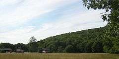
The hill from Brookwood Farm
-

The weather observatory
-
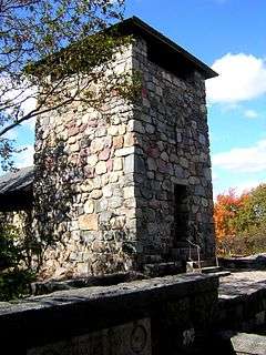
Eliot Memorial Bridge and Tower
-
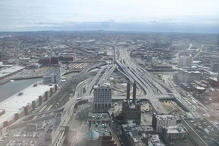
The South Bay interchange (looking south) to the Southeast Expressway with Great Blue Hill visible in the background
References
- 1 2 "Great Blue Hill, Massachusetts". Peakbagger.com. Retrieved 2012-12-18.
- ↑ "Great Blue Hill". Geographic Names Information System. United States Geological Survey. Retrieved 2012-12-18.
- ↑ "The Blue Hills Reservation". Massachusetts Department of Conservation and Recreation. Retrieved 2007-11-29.
- ↑ William Wallace Tooker. Algonquian Names of some Mountains and Hills. 1904.
- ↑ URL last accessed November 23, 2009.
- ↑ "NOAA Weather Radio KHB35". NOAA Weather Radio KHB35.
- ↑ "NOAA Weather Radio Mass.". NOAA Weather Radio Mass. Retrieved 2011-10-23.
- ↑ Piot, Debra K. (4 April 1980). "TV station fires producer for airing April-fool prank". Christian Science Monitor. Retrieved 2 April 2014.
- ↑ "Volcano joke ends in firing". Bowling Green Daily News. 3 April 1980. Retrieved 2 April 2014.
- ↑ http://www.mass.gov/eea/docs/dfg/nhesp/species-and-conservation/nhfacts/crotalus-horridus.pdf
- ↑ http://www.boston.com/yourtown/quincy/articles/2012/07/01/one_of_massachusetts_rarest_snakes_clings_to_survival_in_the_blue_hills/
- ↑ http://www.masnakes.org/snakes/timber_rattle/
External links
- Blue Hills Reservation, information from the Commonwealth's Department of Conservation and Recreation
- Great Blue Hill, technical data from mountainsummits.com
- Blue Hills Ski Area Official site
- The Blue Hill Observatory homepage
- The Blue Hill Observatory, a history of the observatory
- Friends of the Blue Hills, a community preservation group
- The Eruption of Mt. Milton, April Fool's Day, 1980