Great Ayton
| Great Ayton | |
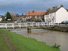 Footbridge over the River Leven in Lower Green |
|
 Great Ayton |
|
| Population | 4,629 [1] |
|---|---|
| OS grid reference | NZ565115 |
| Civil parish | Great Ayton |
| District | Hambleton |
| Shire county | North Yorkshire |
| Region | Yorkshire and the Humber |
| Country | England |
| Sovereign state | United Kingdom |
| Post town | Middlesbrough |
| Postcode district | TS9 |
| Dialling code | 01642 |
| Police | North Yorkshire |
| Fire | North Yorkshire |
| Ambulance | Yorkshire |
| EU Parliament | Yorkshire and the Humber |
| UK Parliament | Richmond |
Coordinates: 54°29′44″N 1°07′45″W / 54.49569°N 1.12919°W
Great Ayton is a village and civil parish in the Hambleton district of North Yorkshire, England, on the edge of the North York Moors. It lies 7 miles (11.3 km) southeast of Middlesbrough and 3 miles (4.8 km) northeast of Stokesley on the border with the unitary authorities of Redcar and Cleveland and Middlesbrough. According to the 2011 Census, it has a population of 4,629. The name Great Ayton derives from the Old English Ea-tun, tun meaning farm and ea meaning river.[2]
History
In the 18th and 19th centuries Great Ayton was a centre for the industries of weaving, tanning, brewing, and tile making: subsequently whinstone was also quarried from the Cleveland Dyke.[3] It was home to the Great Ayton Friends' School (Quaker) from 1841 until it closed in 1997.[4]
Geography
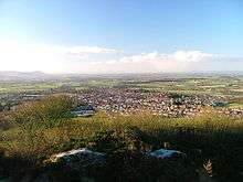
Great Ayton is situated at the foot of the Cleveland Hills beneath Easby Moor and the distinctively-shaped Roseberry Topping. The River Leven, a tributary of the River Tees, flows through the village and links its two centres, High Green and Low Green.
The Cleveland Dyke, a narrow band of hard whinstone rock that runs for about 31 miles between Robin Hood's Bay and Eaglescliffe lies to the north-east of the village.
 |
Nunthorpe | Newton under Roseberry | Roseberry Topping | |
| |
Easby Moor, Battersby | |||
| ||||
| | ||||
| Stokesley | Great Broughton | Easby, Ingleby Greenhow |
Governance
An electoral ward of the same name exists. This ward stretches east to Kildale with a population taken at the 2011 census of 4,973.[5]
Landmarks
The village was the boyhood home of Captain James Cook, the British explorer and navigator and many notable local landmarks relate to this.
The Cook family home on Bridge Street was built by James' father in 1755. The cottage was dismantled in 1934 to be shipped to Australia. Each stone was numbered so that the cottage could be reconstructed exactly in its new home in the Fitzroy Gardens in Melbourne. A granite obelisk now marks the original site of the cottage in Great Ayton. The obelisk is constructed from granite taken from Point Hicks, the first land sighted by Cook in Australia.
The Captain Cook Schoolroom Museum is within a former charity school, founded in 1704 by landowner Michael Postgate. James Cook received his early education here from 1736 to 1740.
A statue, located on High Green, depicts James Cook at the age of 16 looking towards Staithes where, according to tradition, he first felt the lure of the sea. The sculpture was commissioned by Hambleton District Council and is the work of sculptor Nicholas Dimbleby. It was unveiled on 12 May 1997.
In the parish of Little Ayton high on Easby Moor is Captain Cook's Monument a 51 ft (16 m) high obelisk and visible for miles around. It was constructed from local sandstone and was erected in 1827.
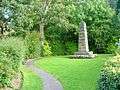 Cook family cottage obelisk
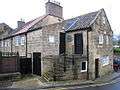 Captain Cook Schoolroom Museum
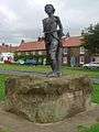 Statue of James Cook as a youth
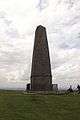 Captain Cook's monument, Easby Moor
Churches
The parish church of Christ Church was built in 1876. It holds a number of services during the day that attract a total attendance of about 200. In the summer months, the evening service takes place in All Saints' Church, the former parish church, which dates back to the 12th century.[6] The church has an organ built by James Jepson Binns.[6] There is also a Methodist Church, Catholic and Religious Society of Friends in the village.
James Cook's mother and siblings are buried in the churchyard of All Saints' Church.[7]
Transport
The village is served by Great Ayton railway station on the Esk Valley Line.
Notable people
The village was the boyhood home of Captain Cook, the British explorer and navigator, who was born in nearby Marton. James Cook and his family moved to the village when he was eight years old and lived there until he was sixteen.
References
- ↑ "Parish population 2011". Neighbourhood Statistics. Office for National Statistics. Retrieved 29 July 2015.
- ↑ "Key to English Place-Names". The University of Nottingham. Archived from the original on 7 June 2015. Retrieved 20 June 2015.
- ↑ O'Sullivan, Dan. "Whinstone Mining" (PDF). Great Ayton - History of the Village. Retrieved 20 June 2015.
- ↑ "Ayton School - the later years" (PDF). Great Ayton - History of the Village. Retrieved 20 June 2015.
- ↑ "Key Figures for 2011 Census: Key Statistics – Area: Great Ayton (Ward)". Neighbourhood Statistics. Office for National Statistics. Retrieved 11 May 2016.
- 1 2 "Christ Church, Great Ayton". A Church Near You. The Church of England. Retrieved 20 June 2015.
- ↑ "All Saints (Old Church), Great Ayton". A Church Near You. The Church of England. Retrieved 12 September 2011.
External links
| Wikimedia Commons has media related to Great Ayton. |
- Great Ayton Tourism, Parish Council, and Community Website
- Great Ayton - Information for visitors from Hambleton District Council
- The Captain Cook Schoolroom Museum Website
- Great Ayton at DMOZ