Gray's Inn Road


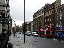
Gray's Inn Road, formerly Gray's Inn Lane, also spelt without the apostrophe, is a major road in central London, in the London Borough of Camden. It is named after Gray's Inn, one of the four Inns of Court. The road starts in Holborn, near Chancery Lane tube station and the boundaries of the City of London and the London Borough of Islington. From here it goes north and slightly west, forming the boundary between Clerkenwell to the east and Holborn, Bloomsbury and finally St Pancras to the west.
Along its course the road passes the Eastman Dental Hospital and the UCL Eastman Dental Institute, Gray's Inn, ITN, ITV and the London Welsh Centre.[1] Near the north end of the road, where it meets Cromer Street and Acton Street, it turns into a one-way system heading towards Kings Cross station.
Throughout its route the road keeps to the higher ground, above the valley of the River Fleet to the east. In earlier times it was the principal route from London to Hampstead.
History
The area of Gray's Inn Road was clearly populated from palaeolithic times[2] and a gravel bed off Gray's Inn Lane (see below) was the find spot for the c. 350,000-year-old Gray's Inn Lane Hand Axe in 1679, one of the important artefacts in the emerging consciousness of human antiquity, now in the British Museum. Given the road's height above the Fleet valley, it may have formed part of an ancient trackway.
The manor of Portpool formerly existed in the same area as Gray's Inn, and although the manor is not mentioned in the Domesday Book it came into possession of the Dean and Chapter of St Paul's Cathedral and may have formed a separate estate of one of the Canons.[3] From at least the 13th century onwards it was in the possession of the Grey family, after whom Gray's Inn is named.
The name "Purtepol Street" is recorded in the time of Henry III and this may be the first reference to the current Gray's Inn Road. In a document of 1299 it is called "Street of Pourtepol without London", which is appropriate as it lies only just outside the boundary of the City. In a document of 1468 the road is called "Graysynlane, otherwise Portpole Lane".[4] Today's Portpool Lane, which leads off Gray's Inn Road to the east, is a separate road which is not mentioned prior to 1641.[5]
On the "Woodcut" map of c.1561, "Greys ynne la." is shown leading from Holborn Bars to Gray's Inn, from where it becomes an unnamed track leading into the country. John Ogilby and William Morgan's map of 1676 shows "Grayes-Inn Lane" which is clearly built up as far as Elm Street, although that is the limit of the map. John Rocque's map of 1738 depicts "Grays Inn Lane" which clearly applies to the stretch from Holborn to the edge of the built up area (somewhat south of the present Calthorpe Street), but when it passes into the country it is called "Road to Hampstead and Highgate".
Richard Horwood's map (updated by William Faden in 1813) calls the whole stretch from Holborn to modern Kings Cross "Grays Inn Lane", but by the mid-19th century it is Gray's Inn Road.
The Bourne Estate is a group of well-regarded Edwardian tenement blocks southeast of the junction with Clerkenwell Road.
References
- ↑ "History: London Welsh Centre". London Welsh Centre website. London Welsh Centre. 2009. Retrieved 3 March 2011.
- ↑ Archaeology, The Lower Palaeolithic Age, British History Online, retrieved December 23, 2007
- ↑ Douthwaite, Gray's Inn - History and Associations, 1886
- ↑ Harben, Dictionary of London, 1918
- ↑ Harben, op. cit.
| Buildings |  | |
|---|---|---|
| Squares and parks | ||
| Roads | ||
| History | ||
Coordinates: 51°31′26″N 0°06′56″W / 51.52376°N 0.11545°W