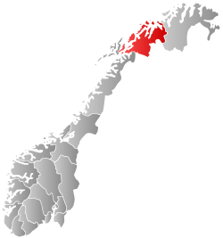
Gratangen
| Gratangen kommune Rivttáid suohkan | |||
|---|---|---|---|
| Municipality | |||
 | |||
| |||
 Gratangen within Troms | |||
| Coordinates: 68°41′24.13″N 17°32′30.29″E / 68.6900361°N 17.5417472°ECoordinates: 68°41′24.13″N 17°32′30.29″E / 68.6900361°N 17.5417472°E | |||
| Country | Norway | ||
| County | Troms | ||
| District | Central Hålogaland | ||
| Administrative centre | Årstein | ||
| Government | |||
| • Mayor (2011) | Ronny Grindstein (Sp) | ||
| Area | |||
| • Total | 312.77 km2 (120.76 sq mi) | ||
| • Land | 305.41 km2 (117.92 sq mi) | ||
| • Water | 7.36 km2 (2.84 sq mi) | ||
| Area rank | 271 in Norway | ||
| Population (2012) | |||
| • Total | 1,136 | ||
| • Rank | 387 in Norway | ||
| • Density | 3.7/km2 (10/sq mi) | ||
| • Change (10 years) | -13.7 % | ||
| Demonym(s) | Gratangsværing[1] | ||
| Time zone | CET (UTC+1) | ||
| • Summer (DST) | CEST (UTC+2) | ||
| ISO 3166 code | NO-1919 | ||
| Official language form | Neutral | ||
| Website |
www | ||
|
| |||

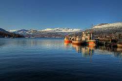
Gratangen (Northern Sami: Rivttáid suohkan) is a municipality in Troms county, Norway. It is part of the traditional region of Central Hålogaland. The administrative centre of the municipality is the village of Årstein.
The largest settlement in the municipality is Årstein, which is located approximately 60 kilometres (37 mi) north of Narvik and 85 kilometres (53 mi) east of Harstad. Other villages in Gratangen include Elvenes, Fjordbotn, and Hilleshamn. The European route E6 highway runs through the southeastern part of the municipality.
General information

The municipality of Gratangen was established on 1 July 1926 when it was separated from the municipality of Ibestad. The initial population of Gratangen was 1,967. The municipal boundaries have not changed since then.[2]
Name
The municipality is named after the Gratangen fjord (Old Norse: Grjótangr). The first element is grjót which means "stone" and the last element is angr which means "fjord".[3]
Coat-of-arms
The coat-of-arms is from modern times (1990). It shows a gray chevron to represent the mountains on a blue background to symbolize the sea.[3]
Churches
The Church of Norway has one parish (sokn) within the municipality of Gratangen. It is part of the Trondenes deanery in the Diocese of Nord-Hålogaland.
| Parish (Sokn) | Church Name | Location of the Church | Year Built |
|---|---|---|---|
| Gratangen | Gratangen Church | Årstein | 1971 |
History
Gratangen was the site of the Battle of Gratangen, one of the first battles between the German 3rd Mountain Division under Eduard Dietl and the Norwegian 6th Division under General Carl Gustav Fleischer after the German invasion of Norway on 9 April 1940.
Geography
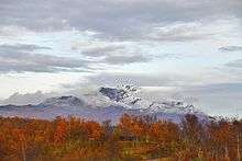
The municipality encompasses the land on both sides of the Gratangen and southeast of the Astafjorden. The municipality borders Skånland to the west, Ibestad (across the Astafjorden) to the north, Lavangen to the east, and Narvik (in Nordland county) to the south.
The municipality is very mountainous, with only one third of the land being below the tree line of 250 to 300 metres (820 to 980 ft) above sea level. Most of the livable land is a narrow area along both sides of the fjord, several side valleys that branch away from the fjord, plus the Fjordbotn area at the head of the fjord.
Climate
| Climate data for Årstein | |||||||||||||
|---|---|---|---|---|---|---|---|---|---|---|---|---|---|
| Month | Jan | Feb | Mar | Apr | May | Jun | Jul | Aug | Sep | Oct | Nov | Dec | Year |
| Daily mean °C (°F) | −6.2 (20.8) |
−5.4 (22.3) |
−2.6 (27.3) |
1.4 (34.5) |
6.7 (44.1) |
10.8 (51.4) |
13.0 (55.4) |
11.9 (53.4) |
7.2 (45) |
2.6 (36.7) |
−2.1 (28.2) |
−4.6 (23.7) |
2.7 (36.9) |
| Average precipitation mm (inches) | 87 (3.43) |
79 (3.11) |
62 (2.44) |
56 (2.2) |
45 (1.77) |
55 (2.17) |
70 (2.76) |
82 (3.23) |
111 (4.37) |
136 (5.35) |
95 (3.74) |
102 (4.02) |
980 (38.58) |
| Source: Norwegian Meteorological Institute[4] | |||||||||||||
Government
All municipalities in Norway, including Gratangen, are responsible for primary education (through 10th grade), outpatient health services, senior citizen services, unemployment and other social services, zoning, economic development, and municipal roads. The municipality is governed by a municipal council of elected representatives, which in turn elect a mayor.
Municipal council
The municipal council (Kommunestyre) of Gratangen is made up of 15 representatives that are elected to every four years. Currently, the party breakdown is as follows:[5]
| Party Name | Name in Norwegian | Number of representatives | |
|---|---|---|---|
| Labour Party | Arbeiderpartiet | 7 | |
| Centre Party | Senterpartiet | 3 | |
| Local Lists | Lokale lister | 5 | |
| Total number of members: | 15 | ||
References
- ↑ "Navn på steder og personer: Innbyggjarnamn" (in Norwegian). Språkrådet. Retrieved 2015-12-01.
- ↑ Jukvam, Dag (1999). "Historisk oversikt over endringer i kommune- og fylkesinndelingen" (PDF) (in Norwegian). Statistisk sentralbyrå.
- 1 2 Store norske leksikon. "Gratangen – kommune i Troms" (in Norwegian). Retrieved 2012-09-03.
- ↑ "eKlima Web Portal". Norwegian Meteorological Institute.
- ↑ "Table: 04813: Members of the local councils, by party/electoral list at the Municipal Council election (M)" (in Norwegian). Statistics Norway. 2015.
External links
| Wikimedia Commons has media related to Gratangen. |
 The dictionary definition of gratangen at Wiktionary
- Municipal fact sheet from Statistics Norway
 Troms travel guide from Wikivoyage