Granville, Ohio
| Granville, Ohio | |
|---|---|
| Village | |
|
Granville streetscape | |
| Motto: "One of Ohio's Best Hometowns" | |
 Location of Granville, Ohio | |
 Location within Licking County | |
| Coordinates: 40°4′3″N 82°30′44″W / 40.06750°N 82.51222°WCoordinates: 40°4′3″N 82°30′44″W / 40.06750°N 82.51222°W | |
| Country | United States |
| State | Ohio |
| County | Licking |
| Government | |
| • Mayor | Melissa Hartfield |
| • Village Manager | Steve Pyles |
| Area[1] | |
| • Total | 4.71 sq mi (12.20 km2) |
| • Land | 4.68 sq mi (12.12 km2) |
| • Water | 0.03 sq mi (0.08 km2) |
| Elevation[2] | 961 ft (293 m) |
| Population (2010)[3] | |
| • Total | 5,646 |
| • Estimate (2012[4]) | 5,638 |
| • Density | 1,206.4/sq mi (465.8/km2) |
| Time zone | Eastern (EST) (UTC-5) |
| • Summer (DST) | EDT (UTC-4) |
| ZIP code | 43023 |
| Area code(s) | 740 |
| FIPS code | 39-31402[5] |
| GNIS feature ID | 1061369[2] |
| Website | Village website |
.jpg)
Granville is a village in Licking County, Ohio, United States. The population was 5,646 at the 2010 census. The village is located in a rural area of rolling hills in central Ohio. It is 35 miles east of Columbus, the state capital, and 7 miles west of Newark, the county seat.
Granville is home to Denison University. The village is known for its New England character and historic architecture, including Greek Revival structures like the Avery Downer House, St. Luke's Episcopal Church (1837) and many others.[6] The Buxton Inn (1812), the Granville Inn (1924), Bancroft House (1834) and Bryn Du Mansion are local landmarks.
History
Pioneer settlers
Granville was founded in 1805 by a colony of settlers from Granville, Massachusetts, who named the new village after their former home. The area was first surveyed in 1797, as land set aside for those who had served in the Revolutionary War. Among the earliest settlers were Theophilus Rees and Thomas Philipps who were born in Wales and left in 1795 for a new life on the American frontier. The village's Welsh heritage is still evident in numerous place names.[7][8]
Early schools
Education was a pillar of early civic life. The village's pioneer settlers had built a three story brick school house by 1820. By the 1830s there were five schools in the village. As those educational institutions continued to develop through the mid and late 19th century, they began to serve students from throughout the region as well as from the village. Among those institutions were the Granville Literary and Theological Institution, the Granville Female Seminary, the Granville Episcopal Female Seminary, the Young Ladies’ Institute, the Granville Female Academy, Doane Academy, and Shepardson College for Women. As several of the institution's names indicate, the education of young women was highly valued by the village's early settlers. Several of these institutions evolved into what is today Denison University.[8][9]
Pre-Columbian culture
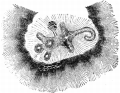
Granville is the location of the prehistoric Alligator Effigy Mound, built by the indigenous people of the Fort Ancient culture, between 800 and 1200 AD, more than four hundred years before European contact. It may be an effigy of the underwater panther featured in Native American mythology. The mound is listed on the National Register of Historic Places. The area is rich in evidence of indigenous cultures. Barely five miles from the Alligator Effigy Mound are the impressive Newark Earthworks, associated with the Hopewell culture.
Geography
Granville is located at 40°4′3″N 82°30′44″W / 40.06750°N 82.51222°W (40.067520, -82.512316).[10] According to the United States Census Bureau, the village has a total area of 4.71 square miles (12.20 km2), of which 4.68 square miles (12.12 km2) is land and 0.03 square miles (0.08 km2) is water.[1]
The central village is situated among three prominent hills. College Hill is to the north. Sugarloaf is a prominent hill and park at the west end of Broadway. Mt. Parnassus is another prominent hill and residential area at the east end of Broadway. A short distance south of the village center is the Raccoon Greek flood plain with the creek running from the west to east.[8]
 Alligator Effigy Mound
.JPG) Bancroft House & Underground Railroad station
Bancroft House & Underground Railroad station%2C_Granville%2C_Ohio.jpg) Buxton Inn (1812)
Buxton Inn (1812)%2C_Granville%2C_Ohio.jpg) Granville Inn (1924)
Granville Inn (1924).jpg) Granville Public Library (1923)
Granville Public Library (1923)%2C_Granville%2C_Ohio_(2).jpg) Granville Public Library Statue (1983)
Granville Public Library Statue (1983) Granville Town Hall
 Granville Seasonal Farmers Market
 Avery-Downer House (Avery-Hunter House)
 St. Luke's Episcopal Church
%2C_Granville%2C_Ohio.jpg) Bryn Du Farm (1865)
Bryn Du Farm (1865) Sugar Loaf Park entrance
 Sugar Loaf Park, Pioneer Monument
 Lake Hudson
 Granville, Ohio, Historical Society & Robinson Research Center
%2C_South_Main_Street_gate%2C_Granville%2C_Ohio.jpg) Old Colony Burying Ground (1805) gate
Old Colony Burying Ground (1805) gate
Education
Village schools
Granville's public schools are operated by the Granville Exempted Village Schools District. The system includes, Granville High School, Granville Middle School, Granville Intermediate School and Granville Elementary School. The high school's graduating class of 2014 included 220 students.[11] The district receives strong performance rankings from the Ohio Department of Education [12] Located in the village is the Granville Christian Academy serving K-12 students. Also, there are several private preschools.

Denison University
On a hill overlooking the village is the campus of Denison University, founded in 1831 as the Granville Theological and Literary Seminary, originally a northern Baptist institution. Today, Denison is a private, residential, non-sectarian liberal arts college with a student body of about 2,100 and a faculty of 200. The school is accredited by the Higher Learning Commission and is certified by the Ohio Board of Regents to grant Bachelor of Arts, Bachelor of Science and Bachelor of Fine Arts degrees. 74% of the student body comes from out of state, including representatives from forty countries.[13] The Homestead at Denison University is a residential student intentional community focusing on environmental sustainability. Swasey Chapel is the iconic campus structure. Completed in 1924, the chapel is named in honor of Ambrose Swasey, a benefactor to the college and prominent Cleveland inventor and businessman.[14]
The history of Granville has been interwoven with that of the college for nearly two centuries. Denison faculty and staff make up an important segment of the village's population, and student patronage is central to many village businesses. Granville residents may take advantage of many university facilities, such as the athletic center, free of charge. The college has recently embarked on a number of in-town purchases, including the Granville Golf Club and the Granville Inn.
Religion
Churches occupy prominent positions at the center of the village and in the life of the community. At the intersection of Broadway and Main Street are located the First Presbyterian Church, Centenary United Methodist Church, St. Luke's Episcopal Church and the United Church of Granville (UCC). Nearby are Pilgrim Lutheran Church and St. Edward's Catholic Church. Also, located in the village are Spring Hills Baptist Church, Church of Jesus Christ of Latter Day Saints, Jehovah's Witnesses, Union Station Community Church and Bethel Apostolic Church.[15]
Granville has a long history of being home to the administrative center of the American Baptist Church in Ohio. Formerly known as the Ohio Baptist Convention, the American Baptist Churches of Ohio's office remains located in the village. Denison University was founded as a Baptist college and had a long association with the church. Like other Ohio independent colleges founded in the nineteenth century by religious denominations, the significance of Denison's church affiliation faded and today the university is a non-sectarian institution.
Demographics
| Historical population | |||
|---|---|---|---|
| Census | Pop. | %± | |
| 1820 | 199 | — | |
| 1830 | 362 | 81.9% | |
| 1840 | 727 | 100.8% | |
| 1850 | 771 | 6.1% | |
| 1860 | 801 | 3.9% | |
| 1870 | 1,109 | 38.5% | |
| 1880 | 1,127 | 1.6% | |
| 1890 | 1,366 | 21.2% | |
| 1900 | 1,425 | 4.3% | |
| 1910 | 1,394 | −2.2% | |
| 1920 | 1,440 | 3.3% | |
| 1930 | 1,467 | 1.9% | |
| 1940 | 1,502 | 2.4% | |
| 1950 | 2,653 | 76.6% | |
| 1960 | 2,868 | 8.1% | |
| 1970 | 3,963 | 38.2% | |
| 1980 | 3,851 | −2.8% | |
| 1990 | 4,244 | 10.2% | |
| 2000 | 3,167 | −25.4% | |
| 2010 | 5,646 | 78.3% | |
| Est. 2015 | 5,747 | [16] | 1.8% |
| Sources:[5][17][18][19][20][21][22][23] | |||
2010 census
As of the census[3] of 2010, there were 5,646 people, 1,441 households, and 1,017 families residing in the village. The population density was 1,206.4 inhabitants per square mile (465.8/km2). There were 1,554 housing units at an average density of 332.1 per square mile (128.2/km2). The racial makeup of the village was 91.9% White, 2.1% African American, 0.1% Native American, 3.6% Asian, 0.6% from other races, and 1.7% from two or more races. Hispanic or Latino of any race were 2.7% of the population.
There were 1,441 households of which 36.8% had children under the age of 18 living with them, 59.3% were married couples living together, 7.9% had a female householder with no husband present, 3.4% had a male householder with no wife present, and 29.4% were non-families. 25.2% of all households were made up of individuals and 11.6% had someone living alone who was 65 years of age or older. The average household size was 2.52 and the average family size was 3.05.
The median age in the village was 22 years. 18.1% of residents were under the age of 18; 38.7% were between the ages of 18 and 24; 12.1% were from 25 to 44; 21.4% were from 45 to 64; and 9.6% were 65 years of age or older. The gender makeup of the village was 46.3% male and 53.7% female.
2000 census
As of the census[5] of 2000, there were 3,167 people, 1,309 households, and 888 families residing in the village. The population density was 790.4 people per square mile (304.9/km²). There were 1,384 housing units at an average density of 345.4 per square mile (133.3/km²). The racial makeup of the village was 96.75% White, 0.69% African American, 0.28% Native American, 1.01% Asian, 0.16% from other races, and 1.11% from two or more races. Hispanic or Latino of any race were 1.14% of the population.
There were 1,309 households out of which 33.4% had children under the age of 18 living with them, 60.4% were married couples living together, 6.3% had a female householder with no husband present, and 32.1% were non-families. 28.5% of all households were made up of individuals and 12.3% had someone living alone who was 65 years of age or older. The average household size was 2.42 and the average family size was 3.00.
In the village the population was spread out with 27.0% under the age of 18, 4.4% from 18 to 24, 25.2% from 25 to 44, 28.8% from 45 to 64, and 14.7% who were 65 years of age or older. The median age was 42 years. For every 100 females there were 94.5 males. For every 100 females age 18 and over, there were 87.7 males.
The median income for a household in the village was $67,689, and the median income for a family was $102,885 . Males had a median income of $72,250 versus $46,484 for females. The per capita income for the village was $39,221. About 3.9% of families and 3.8% of the population were below the poverty line, including none of those under age 18 and 4.8% of those age 65 or over.
Notable people
- Hubert Howe Bancroft, an American historian and ethnologist
- Jonathan Benjamin, last survivor of the French and Indian War[24]
- Ernest DeWitt Burton, an American biblical scholar and president of the University of Chicago
- Paul Carpenter, a minor league baseball player
- Edward Andrew Deeds, inventor and industrialist
- Edmund Burke Fairfield, American minister, educator and politician in the U.S. state of Michigan.
- Ellen Hayes, astronomer and mathematician
- Woody Hayes, a football coach and graduate of Denison University, before leaving to coach at Ohio State University
- Lea Ann Parsley, Olympic silver medalist in the women's skeleton at the 2002 Winter Olympics
- Brian Unger, named one of Entertainment Weekly's "100 Most Creative People in Entertainment" in 1998 and host of the show How the States Got Their Shapes appearing on The History Channel.
- Willard Warner, a brigadier general in the Union Army during the American Civil War
- Lee Wells, contemporary fine artist and curator
- Scott Wiper, writer and director
- Marie Harf, Senior Advisor for Strategic Communications to U.S. Secretary of State
Points of Interest
- Denison University campus
- The Homestead at Denison University intentional & sustainable community
- Avery-Hunter House & Robbins Hunter Museum
- Granville Historical Society [25]
- Historic Houses of Granville, self-guided tour [26]
- Sugarloaf Park, Opera House Park & other local parks
- Alligator Effigy Mound
- Newark Earthworks [27]
- Thomas Evans Trail & Bikeway [28][29]
- Lake Hudson, seasonal swimming, picnicking, camping & fishing [30]
- Polo games at Bryn Du [31]
- Blackhand Gorge State Nature Preserve [32]
- Dawes Arboretum [33]
- Cranberry Bog at Buckeye Lake [34]
References
- 1 2 "US Gazetteer files 2010". United States Census Bureau. Retrieved 2013-01-06.
- 1 2 "US Board on Geographic Names". United States Geological Survey. 2007-10-25. Retrieved 2008-01-31.
- 1 2 "American FactFinder". United States Census Bureau. Retrieved 2013-01-06.
- ↑ "Population Estimates". United States Census Bureau. Retrieved 2013-06-17.
- 1 2 3 "American FactFinder". United States Census Bureau. Retrieved 2008-01-31.
- ↑ "Historic Homes of Granville, Ohio" (PDF). Retrieved June 13, 2016.
- ↑ Overman, William Daniel (1958). Ohio Town Names. Akron, OH: Atlantic Press. p. 53.
- 1 2 3 "Village website, History of Granville". Retrieved June 13, 2016.
- ↑ "Denison, About Denison". Retrieved June 12, 2016.
- ↑ "US Gazetteer files: 2010, 2000, and 1990". United States Census Bureau. 2011-02-12. Retrieved 2011-04-23.
- ↑ "Granville Exempted Village Schools". Retrieved June 12, 2016.
- ↑ "Ohio Department of Education". Retrieved June 12, 2016.
- ↑ "Denison University, Fast Facts". Retrieved June 12, 2016.
- ↑ "Get to Know Denison, central campus". Retrieved August 5, 2016.
- ↑ "Granville, Ohio Area Religious Organizations". Retrieved June 12, 2016.
- ↑ "Annual Estimates of the Resident Population for Incorporated Places: April 1, 2010 to July 1, 2015". Retrieved July 2, 2016.
- ↑ "Population of Civil Divisions Less than Counties" (PDF). Statistics of the Population of the United States at the Tenth Census. U.S. Census Bureau. Retrieved 28 November 2013.
- ↑ "Population of Civil Divisions Less than Counties" (PDF). Statistics of the Population of the United States at the Tenth Census. U.S. Census Bureau. Retrieved 28 November 2013.
- ↑ "Population: Ohio" (PDF). 1910 U.S. Census. U.S. Census Bureau. Retrieved 28 November 2013.
- ↑ "Population: Ohio" (PDF). 1930 US Census. U.S. Census Bureau. Retrieved 28 November 2013.
- ↑ "Number of Inhabitants: Ohio" (PDF). 18th Census of the United States. U.S. Census Bureau. Retrieved 22 November 2013.
- ↑ "Ohio: Population and Housing Unit Counts" (PDF). U.S. Census Bureau. Retrieved 22 November 2013.
- ↑ "Incorporated Places and Minor Civil Divisions Datasets: Subcounty Population Estimates: April 1, 2010 to July 1, 2012". U.S. Census Bureau. Retrieved 25 November 2013.
- ↑ Niles' national register, Volume 61. Cambridge: Harvard University. 1841. p. 192.
- ↑ "Granville Historical Society". Retrieved June 20, 2016.
- ↑ "Historic Homes of Granville, Ohio" (PDF). Retrieved June 20, 2016.
- ↑ "Newark Earthworks". Retrieved June 20, 2016.
- ↑ "Thomas Evans Trail". Retrieved June 20, 2016.
- ↑ "Granville Cycling Trails". Retrieved June 20, 2016.
- ↑ "Lake Hudson". Retrieved June 20, 2016.
- ↑ "Polo at Bryn Du". Retrieved June 20, 2016.
- ↑ "Blackhand Gorge State Nature Preserve". Retrieved June 20, 2016.
- ↑ "Dawes Arboretum". Retrieved June 20, 2016.
- ↑ "Cranberry Bog". Retrieved June 20, 2016.
Further reading
- Granville: The Story of an Ohio Village, William T. Utter, 1956
- Wild Turkeys and Tallow Candles, Ellen Amanda Hayes, 1920
- Denison: The Story of an Ohio College, G. Wallace Chessman, 1957
- The Historical Times, newsletter of the Granville Historical Society
External links
- Village website
- Historic Homes of Granville, Ohio
- The Granville Historical Society
- Granville Exempted Village School District
- Chamber of Commerce
Municipalities and communities of Licking County, Ohio, United States | ||
|---|---|---|
| Cities | 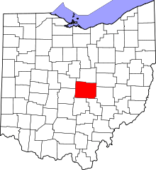 | |
| Villages | ||
| Townships | ||
| CDPs | ||
| Unincorporated communities | ||
| Ghost towns | ||
| Footnotes | ‡This populated place also has portions in an adjacent county or counties | |