Grant City, Missouri
| Grant City, Missouri | |
|---|---|
| City | |
|
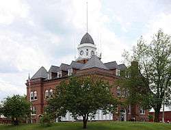
Worth County Courthouse | |
 Location in Worth County and Missouri | |
| Coordinates: 40°29′9″N 94°24′55″W / 40.48583°N 94.41528°WCoordinates: 40°29′9″N 94°24′55″W / 40.48583°N 94.41528°W | |
| Country | United States |
| State | Missouri |
| County | Worth |
| Area[1] | |
| • Total | 1.33 sq mi (3.44 km2) |
| • Land | 1.33 sq mi (3.44 km2) |
| • Water | 0 sq mi (0 km2) |
| Population (2010)[2] | |
| • Total | 859 |
| • Estimate (2012[3]) | 821 |
| • Density | 645.9/sq mi (249.4/km2) |
| Time zone | Central (CST) (UTC-6) |
| • Summer (DST) | CST (UTC-5) |
| ZIP codes | 64456 |
| Area code(s) | 660 |
| Website | http://www.grantcity.us/ |
Grant City is a city in and the county seat of Worth County, Missouri, United States. The population was 859 at the 2010 census.
History
Grant City was laid out in 1864. It was named for General Ulysses S. Grant.[4]
Geography
Grant City is located at 40°29′9″N 94°24′55″W / 40.48583°N 94.41528°W (40.485931, -94.415219).[5] According to the United States Census Bureau, the city has a total area of 1.33 square miles (3.44 km2), all of it land.[1]
Demographics
| Historical population | |||
|---|---|---|---|
| Census | Pop. | %± | |
| 1880 | 493 | — | |
| 1890 | 1,186 | 140.6% | |
| 1900 | 1,406 | 18.5% | |
| 1910 | 1,207 | −14.2% | |
| 1920 | 1,305 | 8.1% | |
| 1930 | 1,126 | −13.7% | |
| 1940 | 1,209 | 7.4% | |
| 1950 | 1,184 | −2.1% | |
| 1960 | 1,061 | −10.4% | |
| 1970 | 1,095 | 3.2% | |
| 1980 | 1,068 | −2.5% | |
| 1990 | 998 | −6.6% | |
| 2000 | 926 | −7.2% | |
| 2010 | 859 | −7.2% | |
| Est. 2015 | 812 | [6] | −5.5% |
Grant City was named for President U.S. Grant. It was here that big band leader Glenn Miller was given his first trombone. There is a marker on the east side of the town square telling of the event.
2010 census
As of the census[2] of 2010, there were 859 people, 378 households, and 227 families residing in the city. The population density was 645.9 inhabitants per square mile (249.4/km2). There were 473 housing units at an average density of 355.6 per square mile (137.3/km2). The racial makeup of the city was 98.4% White, 0.3% African American, 0.1% Native American, 0.1% Asian, 0.8% from other races, and 0.2% from two or more races. Hispanic or Latino of any race were 1.0% of the population.
There were 378 households of which 24.6% had children under the age of 18 living with them, 46.6% were married couples living together, 9.3% had a female householder with no husband present, 4.2% had a male householder with no wife present, and 39.9% were non-families. 36.0% of all households were made up of individuals and 19.3% had someone living alone who was 65 years of age or older. The average household size was 2.13 and the average family size was 2.76.
The median age in the city was 47.4 years. 19.7% of residents were under the age of 18; 8% were between the ages of 18 and 24; 18.1% were from 25 to 44; 27.6% were from 45 to 64; and 26.7% were 65 years of age or older. The gender makeup of the city was 46.4% male and 53.6% female.
2000 census
As of the census[8] of 2000, there were 926 people, 409 households, and 247 families residing in the town. The population density was 735.2 people per square mile (283.8/km²). There were 499 housing units at an average density of 396.2 per square mile (152.9/km²). The racial makeup of the city was 99.03% White, 0.22% African American, 0.65% Native American and 0.11% Asian. Hispanic or Latino of any race were 0.11% of the population.
There were 409 households out of which 27.4% had children under the age of 18 living with them, 46.2% were married couples living together, 10.5% had a female householder with no husband present, and 39.4% were non-families. 36.4% of all households were made up of individuals and 20.0% had someone living alone who was 65 years of age or older. The average household size was 2.17 and the average family size was 2.82.
In the town the population was spread out with 22.9% under the age of 18, 8.5% from 18 to 24, 22.5% from 25 to 44, 21.7% from 45 to 64, and 24.4% who were 65 years of age or older. The median age was 42 years. For every 100 females there were 83.7 males. For every 100 females age 18 and over, there were 78.5 males.
The median income for a household in the town was $23,897, and the median income for a family was $29,943. Males had a median income of $22,813 versus $15,625 for females. The per capita income for the town was $14,009. About 13.4% of families and 17.2% of the population were below the poverty line, including 22.6% of those under age 18 and 16.7% of those age 65 or over.
Notable people
- Phil S. Gibson, 22nd Chief Justice of California.[9]
- Frank E. Lucas, 13th Governor of Wyoming.[10]
- Leon C. Phillips, 11th Governor of Oklahoma.[11]
References
- 1 2 "US Gazetteer files 2010". United States Census Bureau. Retrieved 2012-07-08.
- 1 2 "American FactFinder". United States Census Bureau. Retrieved 2012-07-08.
- ↑ "Population Estimates". United States Census Bureau. Retrieved 2013-05-30.
- ↑ Eaton, David Wolfe (1918). How Missouri Counties, Towns and Streams Were Named. The State Historical Society of Missouri. p. 372.
- ↑ "US Gazetteer files: 2010, 2000, and 1990". United States Census Bureau. 2011-02-12. Retrieved 2011-04-23.
- ↑ "Annual Estimates of the Resident Population for Incorporated Places: April 1, 2010 to July 1, 2015". Retrieved July 2, 2016.
- ↑ "Census of Population and Housing". Census.gov. Retrieved June 4, 2015.
- ↑ "American FactFinder". United States Census Bureau. Retrieved 2008-01-31.
- ↑ "In Memoriam" (PDF). California Supreme Court Historical Society. 1986. Retrieved 30 December 2015.
- ↑ Wyoming History-Frank E. Lucas
- ↑ Sharpe, Barry (Oct 18, 2004). "Leon Chase Phillips". Findagrave.com.
External links
- Historic maps of Grant City in the Sanborn Maps of Missouri Collection at the University of Missouri
Municipalities and communities of Worth County, Missouri, United States | ||
|---|---|---|
| Cities |  | |
| Villages | ||
| Townships |
| |
| Unincorporated communities | ||