Grand Harbour
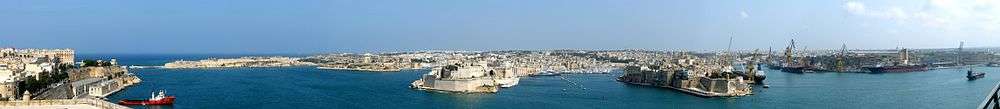

The Grand Harbour (Maltese: il-Port il-Kbir), also known as the Port of Valletta,[1] is a natural harbour on the island of Malta. It has been used as a harbour since at least Phoenician times. The natural harbour has been greatly improved with extensive docks and wharves, and has been massively fortified.
Description


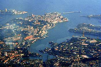
The harbour mouth faces north east and is bounded to the north by Saint Elmo Point and further sheltered by an isolated breakwater and is bounded to the south by Ricasoli Point. Its north west shore is formed by the Sciberras peninsula, which is largely covered by the city of Valletta and its suburb Floriana. This peninsula also divides Grand Harbour from a second parallel natural harbour, Marsamxett Harbour. The main waterway of Grand Harbour continues inland almost to Marsa. The south eastern shore of the harbour is formed by a number of inlets and headlands, principally Rinella Creek, Kalkara Creek, Dockyard Creek, and French Creek, which are covered by Kalkara and the Three Cities: Cospicua, Vittoriosa, and Senglea. The harbour has been described as Malta's greatest geographic asset.[2]
With its partner harbour of Marsamxett, Grand Harbour lies at the centre of gently rising ground. Development has grown up all around the twin harbours and up the slopes so that the whole bowl is effectively one large conurbation. Much of Malta's population lives within a three kilometer radius of Floriana. This is now one of the most densely populated areas in Europe. The harbours and the surrounding areas make up Malta's Northern and Southern Harbour Districts. Together, these districts contain 27 of 68 local councils. They have a population of 213,722 which make up over 47% of the total population of the Maltese islands.[3]
History

The Maltese islands have a long history, mainly due to its strategic location and natural harbours, mainly the Grand Harbour as well as Marsamxett. The Grand Harbour has in fact been used since prehistoric times.
Megalithic remains have been found on the shores of the Grand Harbour. The Kordin Temples, the earliest of which date back to around 3700 BC, overlooked the harbour from Corradino Heights.[4] Another megalithic structure possibly existed underwater off Fort Saint Angelo, but this can no longer be seen.[5] Punic and Roman remains were also found on the shores of the harbour.[4]
By the 12th and 13th centuries, the Castrum Maris had been built in what is now Birgu. It might have been built instead of ancient buildings, possibly Phoenician or Roman temples, or an Arab fortress.[6]
In 1283, the Battle of Malta was fought at the entrance of the Grand Harbour. Aragonese forces defeated a larger Angevin force and captured 10 galleys.[7]
The Grand Harbour was the base for the Order of Saint John for 268 years, from 1530 to 1798. They settled in the city of Birgu and improved its fortifications, including rebuilding the Castrum Maris as Fort Saint Angelo. In July 1551, Barbary corsairs and Ottoman forces raided Malta. They landed at Marsamxett and marched upon the Grand Harbour, but did not attack as they found the town of Birgu too well fortified to attack. Although this attempt was unsuccessful, the Ottoman force later managed to sack Gozo and conquer Tripoli within the same campaign. After the attack, Fort Saint Elmo and Fort Saint Michael were built to better protect the harbour in any future attacks. The city of Senglea was also founded soon afterwards.
Later on in the 1550s, a tornado struck the Grand Harbour, killing 600 people and destroying a shipping armada.
The area was the scene of much of the fighting in the Great Siege of Malta of 1565 when the Ottomans attempted to eject the Order of St John but were ultimately defeated. After the siege, the capital city of Valletta was built on the Sciberras peninsula on the north west shore of the harbour. Over the years, more fortifications and settlements were founded within the Grand Harbour, including Fort Ricasoli and the towns of Floriana and Cospicua.

During the French occupation of Malta, the harbour area was blockaded by Maltese rebels on land and the Royal Navy at sea. The French eventually capitulated in September 1800 and Malta became a British protectorate, later a colony. During the British colonial rule, the harbour became a strategic base for the Royal Navy and the base of the Mediterranean Fleet.

The whole area was savagely bombed during the Second Siege of Malta during World War II, as the docks and military installations around the port were legitimate targets for Axis bombers. However collateral damage wrecked much of Valletta and The Three Cities, and caused large numbers of civilian casualties.
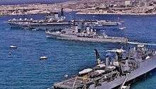
Malta Dockyard is still active but with the departure of the British Military the harbour lost much of its military significance. A considerable part of Malta's commercial shipping is now handled by the new free port at Kalafrana, so the harbour is much quieter than it was in the first half of the 20th century.[8]
A Vision for Malta's Grand Harbour
The Grand Harbour, the backdrop to Malta's history, is set to experience a regeneration as in September 2007, the Maltese Government unveiled 20 proposed projects that would revamp the area while respecting its historic value.[9]
The 20 proposals are these:
- A New Cruise Liner Terminal in Senglea
- Extending the Valletta Cruise Liner Terminal
- One promenade from Ricasoli all the way to Senglea
- New yacht marina in Kalkara
- Conversion of Sir Paul Boffa hospital into a hotel
- A new tourism and cultural sector
- A center for the audio-visual industry in Fort Ricasoli
- Restoration of Villa Bighi
- Super yachts along the Senglea waterfront
- Discontinuing the Cleaning of Tanks
- A Commercial Maritime Park
- Maritime institute
- Maritime services
- Closing down the Marsa Power Station
- Afforestation of the Rinella Valley
- Rinella Creek
- New maritime infrastructure in Kalkara
- The reorganisation of Xatt il-Mollijiet
- Extension of quay infrastructe in Coradino
- A Base for Towing Services in Xatt il-Knisja
Around the Grand Harbour from Fort Ricasoli to Fort St. Elmo

- Fort Ricasoli
- Rinella Bay
- Bighi
- Kalkara Creek
- Fort St. Angelo
- Dockyard Creek or Cottonera Marina
- Fort Saint Michael
- French Creek
- Dock No. 2
- Ghajn Dwieli Road
- Corradino
- Dock No. 6
- Ras Ħanżir Point
- New Port
- Il-Menqa
- Bridge Wharf, Marsa
- Braken Wharf, Marsa
- Il-Moll tal-Ħatab, Marsa
- Moll iċ-Ċangatura, Marsa
- Xatt l-Għassara tal-Għeneb, Marsa
- Valletta Waterfront or Pinto Wharf, Floriana
- Lascaris Wharf, Valletta
- Xatt il-Barriera, Valletta
- Taħt iż-Żiemel
- Fort St. Elmo
Gallery
_03_ies.jpg) Ricasoli Breakwater
Ricasoli Breakwater
Kalkara Fort Ricasoli
Kalkara_01_ies.jpg) Rinella Bay
Rinella Bay
Kalkara Bighi
Bighi
Kalkara_01_ies.jpg) Kalkara Creek
Kalkara Creek
Kalkara and Birgu_01_ies.jpg) Fort Saint Angelo
Fort Saint Angelo
Birgu_01_ies.jpg) Dockyard Creek
Dockyard Creek
Birgu, Cospicua and Senglea Cottonera Marina
Birgu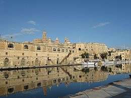 Dock No. 1
Cospicua_01_ies.jpg) The Spur
The Spur
Senglea_01_ies.jpg) French Creek
French Creek
Senglea, Cospicua and Paola_01_ies.jpg) Dock No. 2
Dock No. 2
Senglea_01_ies.jpg) Dock No. 4
Dock No. 4
Cospicua Dock No. 6 (China Dock)
Cospicua_01_ies.jpg) Dock No. 7
Dock No. 7
Cospicua_01_ies.jpg) Shipwrights Wharf
Shipwrights Wharf
Paola and Marsa Bridge Wharf and Marsa Power Station
Marsa_02_ies.jpg) Braken Wharf
Braken Wharf
Marsa_07_ies.jpg) Xatt l-Għassara tal-Għeneb
Xatt l-Għassara tal-Għeneb
Marsa and Floriana_01_ies.jpg) Valletta Cruise Port
Valletta Cruise Port
Floriana_01_ies.jpg) Valletta Waterfront
Valletta Waterfront
Floriana_01_ies.jpg) Xatt Lascaris
Xatt Lascaris
Valletta_02_ies.jpg) Xatt il-Barriera
Xatt il-Barriera
Valletta_01_ies.jpg) Triq il-Lanċa
Triq il-Lanċa
Valletta Fort Saint Elmo
Valletta_07_ies.jpg) Saint Elmo Bridge
Saint Elmo Bridge
Valletta_01_ies.jpg) Valletta Breakwater
Valletta Breakwater
Valletta
See also
References
- ↑ "Port of Valletta". Transport Malta. Retrieved 5 November 2014.
- ↑ Agius, Raymond. "The Grand Harbour in Malta". agius.com. Retrieved 5 November 2014.
- ↑ "Estimated Population by Locality 31st March, 2013" (PDF). Malta Government Gazette 19,094. Retrieved 31 October 2014.
- 1 2 Vella, Nicholas C. (2004). The Prehistoric Temples at Kordin III. Santa Venera: Heritage Books. ISBN 9993239879.
- ↑ Coppens, Philip. "Malta: the small island of the giants". philipcoppens.com. Retrieved 2 May 2015.
- ↑ "Fort St Angelo". Lonely Planet. Retrieved 5 November 2014.
- ↑ Said, Frans (30 June 2013). "The Battle of Malta 730 years ago". Times of Malta. Retrieved 5 November 2014.
- ↑ Bugeja, Lino (11 August 2013). "The historical importance of Malta's Grand Harbour". Times of Malta. Retrieved 31 October 2014.
- ↑ "Government's Vision for Grand Harbour will generate jobs and investment – MEA". The Malta Independent. 8 September 2007. Retrieved 5 November 2014.
External links
| Wikimedia Commons has media related to Grand Harbour. |