Corn Belt
The Corn Belt is a region of the Midwestern United States where corn (maize) has, since the 1850s, been the predominant crop, replacing the native tall grasses. By 1950, 99% of the corn was grown from hybrids. Most corn is fed to livestock, especially hogs and poultry. In recent decades soybeans have grown in importance. The U.S. produces 40% of the world crop.[1]
Geography
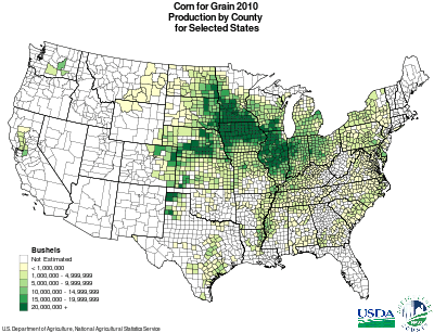
Geographic definitions of the region vary. Typically, it is defined to include: Iowa, Illinois, Indiana, southern Michigan, western Ohio, eastern Nebraska, eastern Kansas, southern Minnesota and parts of Missouri.[2] As of 2008, the top four corn-producing states were Iowa, Illinois, Nebraska and Minnesota, together accounting for more than half of the corn grown in the United States.[3] The Corn Belt also sometimes is defined to include parts of South Dakota, North Dakota, Indiana, Ohio, Wisconsin, Michigan, and Kentucky.[4] The region is characterized by relatively level land and deep, fertile soils, high in organic matter.[5]
More generally, "Corn Belt" represents the most intensively agricultural region of the Midwest, connoting a lifestyle based on ownership of family farms, with supporting small towns and powerful farm organizations that lobbied to obtain higher prices.[6][7]
History
In the era from 1860 to 1970, new agricultural technology transformed the Corn Belt from a mixed crop-and-livestock farming area to a highly specialized cash-grain farming area. While the landscape was greatly modified, the family farm remained the normal form. Its acreage doubled, as farmers bought out their neighbors (who then moved to nearby towns). After 1970 increased crop and meat production required an export outlet, but global recession and a strong dollar reduced exports, depressed prices below costs of production, and created serious problems even for the best farm managers.[2]
Vice President Henry A. Wallace, a politician and pioneer of hybrid seeds, declared in 1956 that the Corn Belt developed the "most productive agricultural civilization the world has ever seen".[8]
EPA Ecoregion
In 1997, the USEPA published its report on United States' ecoregions, in part based on "land use." Its "Level III" region classification contains three contiguous "Corn Belt" regions, Western (47), Central (54), and Eastern (55), stretching from Indiana to eastern Nebraska.[9][10]
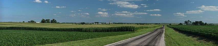
Panoramic views
See also
- Breadbasket
- Canadian Prairies, Canada's 'Breadbasket'
- Central Black Earth Region, segment of the Eurasian chernozem belt that lies within Central Russia
- Palliser's Triangle, Canada's semi-arid grain production region
- Peak wheat
References
- ↑ Smith, C. Wayne., Javier Betrán, and E. C. A. Runge. Corn: Origin, History, Technology, and Production. Hoboken, NJ: John Wiley, 2004. page 4. Print
- 1 2 Hart (1986)
- ↑ USDA State Fact sheets
- ↑ U.S. Department of Agriculture
- ↑ Corn Belt, Encyclopædia Britannica Online
- ↑ John Mark Hansen, Gaining access: Congress and the farm lobby, 1919-1981 (1991) p, 138
- ↑ Thomas F. McIlwraith and Edward K. Muller, North America: the historical geography of a changing continent (2001) p, 186
- ↑ Edward L. Schapsmeier and Frederick H. Schapsmeier, Prophet in Politics: Henry A. Wallace and the War Years, 1940-1965 (1970) p, 234
- ↑ "Ecological Regions of North America: Toward a Common Perspective" (PDF). Commission for Environmental Cooperation. 1997. Retrieved 2008-04-10.
- ↑ "Ecoregion Maps and GIS Resources". United States Environmental Protection Agency. Retrieved 2008-04-10.
Further reading
- Anderson, J. L. Industrializing the Corn Belt: Agriculture, Technology, and Environment, 1945-1972 (2009) 238 pp. ISBN 978-0-87580-392-0
- Bogue, Allan. From Prairie to Corn Belt: Farming on the Illinois and Iowa Prairies in the Nineteenth Century (1963) excerpt and text search
- Cayton, Andrew, et al. eds. The American Midwest: An Interpretive Encyclopedia (2006) excerpt and text search
- Hart, John Fraser. "Change in the Corn Belt," Geographical Review, Jan 1986, Vol. 76#1 pp 51–72
- Hudson, John C. Making the Corn Belt: A Geographical History of Middle-Western Agriculture (1994)
- Power, Richard Lyle. Planting Corn Belt Culture: The Impress of the Upland Southerner and Yankee in the old Northwest (1953)
- Snapp, Roscoe R. Beef Cattle Their Feeding and Management in the Corn Belt States (1950)
- Smith, C. Wayne, et al. Corn: Origin, History, Technology, and Production (2004) online edition
- Wallace, Henry Agard. Henry A. Wallace's Irrigation Frontier: On the Trail of the Corn Belt Farmer 1909 15 articles written by Wallace in 1909; 1991 edition edited by Richard Lowitt, and Judith Fabry
External links
| Wikimedia Commons has media related to Maize. |
Coordinates: 41°N 90°W / 41°N 90°W