Gradiška, Bosnia and Herzegovina
| Gradiška Градишка (Bosanska Gradiška) | ||
|---|---|---|
 | ||
| ||
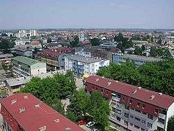
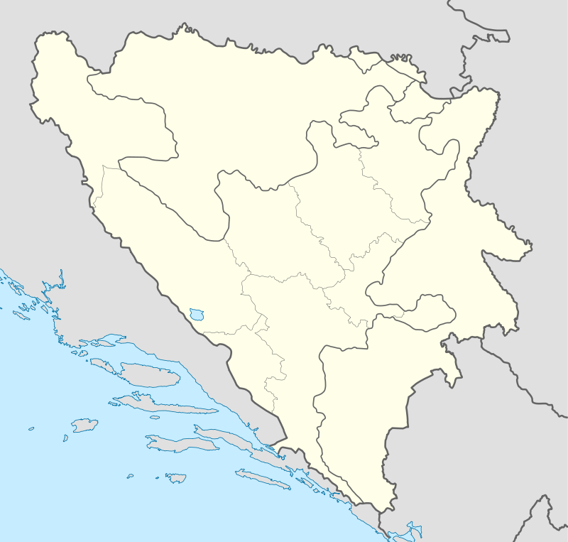 Gradiška Location of Gradiška | ||
| Coordinates: 45°08′N 17°15′E / 45.133°N 17.250°E | ||
| Country |
| |
| Entity |
| |
| Region | Bosanska Krajina | |
| Government | ||
| • Mayor | Zoran Adžić (SNSD) | |
| Area | ||
| • Total | 761,74 km2 (29,411 sq mi) | |
| Elevation | 163 m (535 ft) | |
| Population (2013 census) | ||
| • Total | 56,727 | |
| • Density | 74,5/km2 (1,930/sq mi) | |
| Time zone | CET (UTC+1) | |
| • Summer (DST) | CEST (UTC+2) | |
| Postal code | 78400 | |
| Area code(s) | +387 51 | |
| Website | Official website of the municipality | |

Bosanska Gradiška (Serbian Cyrillic: Градишка)[1][2][3] is a town and municipality in northwestern Bosnia and Herzegovina, part of the Republika Srpska entity. The municipality is geographically located in eastern Krajina region, and the town is situated on the Lijevče plain, on the right bank of the Sava river across from Stara Gradiška, Croatia, and about 40 km (25 mi) north of Banja Luka.
History
In the Roman period, the municipium of Serbinum existed on the location of the present-day town. It was of strategical importance; a port of the Roman fleet was situated here. Among notable archaeological findings are a viaduct.
Gradiški Brod is mentioned for the first time as a town in c. 1330. It had a major importance as the location where the Sava river used to be crossed. By 1537, the town and its surroundings came under Ottoman rule.
The Ottoman built a fortress, which served as the Bosnia Eyalet's northern defense line. The town was also called Berbir because of the fortress.
Following the outbreak of the First Serbian Uprising (1804), in the Sanjak of Smederevo (modern Central Serbia), the Jančić's Revolt broke out in the Gradiška region against the Ottoman government in the Bosnia Eyalet, following the erosion of the economic, national and religious rights of Serbs. Hajduks also arrived from Serbia, and were especially active on the Kozara. Jovan Jančić Sarajlija organized the uprising with help from Metropolitan Benedikt Kraljević. The peasants took up arms on 23 September 1809, in the region of Gradiška, beginning from Mašići. The fighting began on 25 September, and on the same night, the Ottomans captured and executed Jančić. The rebels retreated to their villages, except those in Kozara and Motajica who continued, and offered strong resistance until their defeat in mid-October, after extensive looting and burning of villages by the Ottomans.[4] Another revolt broke out in 1834, in Mašići.[5]
Ottoman rule ended with the Austro-Hungarian occupation of Bosnia and Herzegovina (1878), following the Herzegovina Uprising (1875–77). Austro-Hungarian rule in Bosnia and Herzegovina ended in 1918, when the South Slavic Austro-Hungarian territories proclaimed the State of Slovenes, Croats and Serbs, which subsequently joined the Kingdom of Serbia into the Kingdom of Yugoslavia.
From 1929 to 1941 Gradiška was part of the Vrbas Banovina of the Kingdom of Yugoslavia.
During Yugoslavia, the town was known as Bosanska Gradiška. During the Bosnian War, the town was incorporated into Republika Srpska (RS). After the war, the RS National Assembly changed the name, omitting bosanska ("Bosnian"), as was done with many other towns (Kostajnica, Dubica, Novi Grad, Petrovo, Šamac).
Culture
.jpg)
The town has a Serbian Orthodox cathedral dedicated to the Mother of God.
Demographics
1971
53,581 total
- Serbs - 35,038 (65.39%)
- Bosniaks - 12,688 (23.68%)
- Croats - 4,415 (8.23%)
- Yugoslavs - 415 (0.77%)
- Others - 1,025 (1.93%)
1991
In 1991, the municipality of Gradiška had a population of 59,974, including:
- 35,297 Serbs (49.4%)
- 15,310 Bosniaks (29.2%)
- 1,894 Croats (3.2%)
- 1,811 Yugoslavs (3.0%)
- 1,342 others (2.5%)
The town of Gradiška itself had 18,671 residents, including:
- 43.5% Serbs
- 37.7% Bosniaks
- 10.3% Yugoslavs
- 4.6% Croats
- 3.9% others
Settlements
The municipality includes total of 75 settlements:
Notable residents
- Marko Marin, German footballer
- Zvjezdan Misimović, footballer
- Vaso Čubrilović, politician and historian, member of Black Hand organisation and participant in the conspiracy to kill Archduke Franz Ferdinand of Austria.
- Veljko Čubrilović, member of Black Hand organisation
- A. Setyabudi, artist
- Vlado Jagodić, former footballer, now manager
- Vinko Marinović, former Serbian footballer, now manager
- Radenko Milak, artist
- Gojko Subotić, academic and art historian
- Tatjana Pašalić, poker presenter
- Samson Morpurgo, Medieval Italian rabbi, physician, and liturgist
- Nordin Gerzić, Swedish footballer
- Alojzije Mišić, Roman Catholic bishop
- Branko Grahovac, football goalkeeper
- Atif Dudaković, Bosnian war-time army general
- Nazif Hajdarović, footballer
- Ratko Varda, basketball player
- Milan Janković, footballer
- Miodrag Latinović, retired footballer
- Zlatko Janjić, footballer
- Ozren Perić, footballer
- Safet Halilović, politician
- Ognjen Ožegović, Serbian footballer, European U-19 champion
Twin towns – Sister cities
 Kavala, Greece, since 1994
 Ćuprija, Serbia, since 1994
 Negotino, Macedonia, since 2006
-
 Bolesławiec, Poland since 2015
See also
References
- ↑ the official web site of the municipality Gradiška/Градишка.
- ↑ "Systemic census of municipalities and populated places of Bosnia and Herzegovina" (PDF). Sarajevo: Agency for Statistics of Bosnia and Herzegovina. 2013. p. 7. Retrieved 16 July 2015.
- ↑ "Preliminary results of the 2013 Census of Population, Households and Dwellings in Bosnia and Herzegovina" (PDF). bhas.ba. Sarajevo: Agency for Statistics of Bosnia and Herzegovina. 5 November 2013. p. 8. Retrieved 16 July 2015.
- ↑ Стојан Бијелић. Машићка буна. Врбаске новине бр. 107 ст. 5, 1933. (извор)
- ↑ :: Www.Gradiskasela.Net ::
External links
- Official site of the municipality
- www.gradiska.com
- www.gradiska.ba
- Gradiška TV
- VIKOM RADIO TELEVIZIJA
Coordinates: 45°08′N 17°15′E / 45.133°N 17.250°E
| Wikimedia Commons has media related to Gradiška. |