Grade II* listed buildings in Three Rivers
There are over 20,000 Grade II* listed buildings in England. This page is a list of these buildings in the district of Three Rivers in Hertfordshire.
Three Rivers
| Name | Location | Type | Completed [note 1] | Date designated | Grid ref.[note 2] Geo-coordinates |
Entry number [note 3] | Image |
|---|---|---|---|---|---|---|---|
| Church of St Paul | Langleybury, Abbots Langley, Three Rivers | Parish Church | 1863-5 | 3 October 1985 | TL0805300569 51°41′37″N 0°26′17″W / 51.693482°N 0.438098°W |
1100890 | 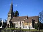 |
| Hunton Park | Hunton Bridge, Abbots Langley, Three Rivers | Country House | 1909 | 31 May 1985 | TL0892200525 51°41′35″N 0°25′32″W / 51.692919°N 0.425544°W |
1173193 | 
|
| Langleybury House (the Mansion and Flats 1 to 6 Inclusive) | Langleybury, Abbots Langley, Three Rivers | Apartment | 1727 | 1 September 1953 | TL0775700200 51°41′25″N 0°26′33″W / 51.690223°N 0.442493°W |
1173157 |
|
| The King's Lodge | Hunton Bridge, Abbots Langley, Three Rivers | House | c. 1640 | 2 April 1966 | TL0835400570 51°41′36″N 0°26′01″W / 51.693433°N 0.433745°W |
1100913 |
|
| Tithe Barn about 20m north-east of Parsonage Farm | Abbots Langley, Three Rivers | Tithe Barn | 15th century | 17 October 1977 | TL0954202610 51°42′42″N 0°24′57″W / 51.711538°N 0.415924°W |
1100908 |
|
| Christ Church | Chorleywood, Three Rivers | Parish Church | 1845 | 16 July 1975 | TQ0360096572 51°39′30″N 0°30′13″W / 51.658395°N 0.503684°W |
1348233 |  |
| Kings John's Farm, Penn Cottage, Penn Farm and Garden Wall | Chorleywood, Three Rivers | House | c. 1910 | 19 May 1950 | TQ0271295321 51°38′50″N 0°31′01″W / 51.647314°N 0.516884°W |
1100897 |
|
| Church of the Holy Cross | Church End, Sarratt, Three Rivers | Parish Church | Late 12th century | 1 September 1953 | TQ0387498398 51°40′29″N 0°29′57″W / 51.674757°N 0.499182°W |
1348246 |  |
| Little Winch | Chipperfield, Sarratt, Three Rivers | House | 1935 | 3 October 1985 | TL0383301182 51°41′59″N 0°29′56″W / 51.699788°N 0.498947°W |
1100809 |
|
| Redheath | Croxley Heath, Sarratt, Three Rivers | Country House/School | 16th century | 1 September 1953 | TQ0665796985 51°39′42″N 0°27′34″W / 51.661536°N 0.459381°W |
1347875 | .jpg) |
| The Grove | Sarratt, Three Rivers | Country House | Late 16th century | 15 November 1973 | TQ0821298789 51°40′39″N 0°26′11″W / 51.677453°N 0.43635°W |
1101580 |  |
| Oxhey Chapel | Oxhey, Watford Rural, Three Rivers | Chapel | 1612 | 1 September 1953 | TQ1136493347 51°37′41″N 0°23′33″W / 51.627927°N 0.392513°W |
1174300 | 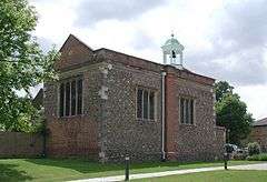 |
| Oxhey Hall | Oxhey, Watford Rural, Three Rivers | House | Early 17th century | 3 October 1985 | TQ1036794368 51°38′14″N 0°24′24″W / 51.6373°N 0.40659°W |
1347877 |
|
| Tithe Barn at Croxley Hall Farm | Croxley Hall Farm, Three Rivers | Tithe Barn | 1396-1401 | 2 April 1970 | TQ0699994592 51°38′24″N 0°27′19″W / 51.639963°N 0.45517°W |
1296113 | |
Notes
- ↑ The date given is the date used by Historic England as significant for the initial building or that of an important part in the structure's description.
- ↑ Sometimes known as OSGB36, the grid reference is based on the British national grid reference system used by the Ordnance Survey.
- ↑ The "List Entry Number" is a unique number assigned to each listed building and scheduled monument by Historic England.
External links
![]() Media related to Grade II* listed buildings in Hertfordshire at Wikimedia Commons
Media related to Grade II* listed buildings in Hertfordshire at Wikimedia Commons
This article is issued from Wikipedia - version of the 12/2/2016. The text is available under the Creative Commons Attribution/Share Alike but additional terms may apply for the media files.