Gréasque
| Gréasque | ||
|---|---|---|
|
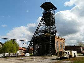
Headframe of the Hély d'Oissel coal mine, registered as an historic monument in 1989 | ||
| ||
 Gréasque | ||
|
Location within Provence-A.-C.d'A. region  Gréasque | ||
| Coordinates: 43°25′50″N 5°32′21″E / 43.4306°N 5.5392°ECoordinates: 43°25′50″N 5°32′21″E / 43.4306°N 5.5392°E | ||
| Country | France | |
| Region | Provence-Alpes-Côte d'Azur | |
| Department | Bouches-du-Rhône | |
| Arrondissement | Marseille | |
| Canton | Roquevaire | |
| Government | ||
| • Mayor (2008–2014) | Suzanne Maurel-Chordi | |
| Area1 | 6.15 km2 (2.37 sq mi) | |
| Population (2008)2 | 3,948 | |
| • Density | 640/km2 (1,700/sq mi) | |
| Time zone | CET (UTC+1) | |
| • Summer (DST) | CEST (UTC+2) | |
| INSEE/Postal code | 13046 / 13850 | |
| Dialling codes | 0442 | |
| Elevation | 276–385 m (906–1,263 ft) | |
|
1 French Land Register data, which excludes lakes, ponds, glaciers > 1 km² (0.386 sq mi or 247 acres) and river estuaries. 2 Population without double counting: residents of multiple communes (e.g., students and military personnel) only counted once. | ||
.svg.png)
Gréasque is a commune northeast of Marseille in the department of Bouches-du-Rhône in the Provence-Alpes-Côte d'Azur region in southern France. It was traditionally a mining town.
Population
| Historical population | ||
|---|---|---|
| Year | Pop. | ±% |
| 1793 | 202 | — |
| 1800 | 209 | +3.5% |
| 1806 | 240 | +14.8% |
| 1821 | 259 | +7.9% |
| 1831 | 310 | +19.7% |
| 1836 | 298 | −3.9% |
| 1841 | 371 | +24.5% |
| 1846 | 402 | +8.4% |
| 1851 | 466 | +15.9% |
| 1856 | 485 | +4.1% |
| 1861 | 557 | +14.8% |
| 1866 | 685 | +23.0% |
| 1872 | 802 | +17.1% |
| 1876 | 854 | +6.5% |
| 1881 | 903 | +5.7% |
| 1886 | 831 | −8.0% |
| 1891 | 821 | −1.2% |
| 1896 | 775 | −5.6% |
| 1901 | 815 | +5.2% |
| 1906 | 792 | −2.8% |
| 1911 | 849 | +7.2% |
| 1921 | 1,172 | +38.0% |
| 1926 | 1,806 | +54.1% |
| 1931 | 1,898 | +5.1% |
| 1936 | 1,671 | −12.0% |
| 1946 | 1,742 | +4.2% |
| 1954 | 2,053 | +17.9% |
| 1962 | 2,073 | +1.0% |
| 1968 | 2,309 | +11.4% |
| 1975 | 2,439 | +5.6% |
| 1982 | 2,674 | +9.6% |
| 1990 | 3,081 | +15.2% |
| 1999 | 3,576 | +16.1% |
| 2008 | 3,948 | +10.4% |
The inhabitants are called Gréasquéens.
See also
References
External links
| Wikimedia Commons has media related to Gréasque. |
- (French) Official town website
This article is issued from Wikipedia - version of the 3/15/2016. The text is available under the Creative Commons Attribution/Share Alike but additional terms may apply for the media files.