Gostyń
| Gostyń | ||
|---|---|---|
|
Basilica of Święta Góra | ||
| ||
 Gostyń | ||
| Coordinates: 51°52′45″N 17°0′45″E / 51.87917°N 17.01250°E | ||
| Country |
| |
| Voivodeship | Greater Poland | |
| County | Gostyń County | |
| Gmina | Gmina Gostyń | |
| Area | ||
| • Total | 10.79 km2 (4.17 sq mi) | |
| Elevation | 90 m (300 ft) | |
| Population (2006) | ||
| • Total | 20,588 | |
| • Density | 1,900/km2 (4,900/sq mi) | |
| Postal code | 63–800 | |
| Website | http://www.gostyn.pl/ | |


Gostyń [ˈɡɔstɨɲ] (German: Gostingen) is a town in Greater Poland Voivodeship (from 1975 to 1998 in Leszno Voivodship), in Gostyń County. According to 30 June 2004 data its population was 20,746.
The total area of Gostyń is 10.79 square kilometres (4.17 sq mi). The town comprises 1% of the area of the county and 8% of the commune, according to Główny Urząd Statystyczny.
The main landmark of Gostyń is Basilica of Święta Góra (Holy Hill), the main Marian sanctuary of the archdiocese of Poznań and a masterpiece of Pompeo Ferrari, with the monastery of the Oratory of Saint Philip Neri.
History
World War II
During the Nazi German occupation of Poland Gostyń became the site of public executions and deportation actions. On 21 October 1939 some 30 citizens of the town whose names were listed in the Sonderfahndungsbuch Polen (Special Prosecution Book-Poland) prepared by local German minority, were executed by an Einsatzkommando. Mass deportations began on 4 December 1939, with up to 2,000 Poles deported to General Government on the orders of SS-Standartenführer Ernst Damzog stationing in Poznań. Between spring of 1940 and 15 March 1941 additional 3,222 were deported.[1]
Demographics
Data for 31 December 2003:
| Total | % | Female | % | Male | % | |
|---|---|---|---|---|---|---|
| Population | 20,929 | 100 | 10 886 | 52 | 10 043 | 48 |
| employed | 6 630 | 32 | 3 103 | 15 | 3 527 | 17 |
| population density (persons/km²) |
1939 | 990 | 913 |
Data for 30 June 2004:
| Total | % | Female | % | Male | % | ||
|---|---|---|---|---|---|---|---|
| population | 20,746 | ↓ | 100 | 10 798 | 52 | 9 948 | 48 |
| population density (persons/km²) |
1922 | ||||||
Gallery
 St. Margaret's Church
 Market Square
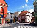 The town centre
 Town Hall
| Wikimedia Commons has media related to Gostyń. |
References
- ↑ Robert Czub. "Pierwsze wysiedlenia Gostynian do Generalnego Gubernatorstwa – 8 grudnia 1939 roku" (PDF). Expulsions of Poles. Muzeum.Gostyn.pl. Retrieved 20 June 2012.
- UM.Gostyn.pl in Polish, English, and German
- Gostyn at Gostyn24.pl
- Gostyn Virtual Tour at Wirtualnygostyn.pl
Coordinates: 51°53′N 17°01′E / 51.883°N 17.017°E
| Seat |  | |
|---|---|---|
| Urban-rural gminas | ||
| Rural gminas | ||