Goshen, Indiana
| Goshen, Indiana | |
|---|---|
| City | |
|
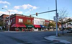
Downtown Goshen (2005) | |
| Nickname(s): "The Maple City" | |
 Location within Elkhart County and Indiana | |
| Coordinates: 41°34′55″N 85°50′12″W / 41.58194°N 85.83667°W | |
| Country | United States |
| State | Indiana |
| County | Elkhart |
| Government | |
| • Mayor | Jeremy Stutsman[1][2] (D) |
| Area[3] | |
| • Total | 16.59 sq mi (42.97 km2) |
| • Land | 16.23 sq mi (42.04 km2) |
| • Water | 0.36 sq mi (0.93 km2) |
| Elevation | 801 ft (244 m) |
| Population (2010)[4] | |
| • Total | 31,719 |
| • Estimate (2012[5]) | 32,064 |
| • Density | 1,954.3/sq mi (754.6/km2) |
| Time zone | EST (UTC-5) |
| • Summer (DST) | EDT (UTC-4) |
| ZIP codes | 46526-46528 |
| Area code(s) | 574 |
| FIPS code | 18-28386[6] |
| GNIS feature ID | 0435227[7] |
| Website | goshenindiana.org |
Goshen /ˈɡoʊʃən/ is a city in and the county seat of Elkhart County, Indiana, United States.[8] It is the smaller of the two principal cities of the Elkhart-Goshen Metropolitan Statistical Area, which in turn is part of the South Bend-Elkhart-Mishawaka Combined Statistical Area. It is located in the northern part of Indiana near the Michigan border, in a region known as Michiana. Goshen is located 10 miles southeast of Elkhart, 25 miles southeast of South Bend, 120 miles east of Chicago, and 150 miles north of Indianapolis. The population was 31,719 at the 2010 census. The city is known as a center of manufacturing for recreational vehicles and accessories, the home of Goshen College, a small Mennonite liberal arts college, and home to the Elkhart County 4-H Fair, one of the largest county fairs in the United States.[9]
History
Goshen was platted in 1831.[10] It was named after the Land of Goshen.[11] The initial settlers consisted entirely of old stock "Yankee" immigrants, who were descended from the English Puritans who settled New England in the 1600s.[12] The New England Yankee population that founded towns such as Goshen considered themselves the "chosen people" and identified with the Israelites of the Old Testament and they thought of North America as their Canaan. They founded a large number of towns and counties across what is known as the Northern Tier of the upper midwest. It was in this context that Goshen was named.[12][13]
The Yankee migration to Indiana was a result of several factors, one of which was the overpopulation of New England. The old stock Yankee population had large families, often bearing up to ten children in one household. Most people were expected to have their own piece of land to farm, and due to the massive and nonstop population boom, land in New England became scarce as every son claimed his own farmstead. As a result, there was not enough land for every family to have a self-sustaining farm, and Yankee settlers began leaving New England for the Midwestern United States.[14]
They were aided in this effort by the construction and completion of the Erie Canal which made traveling to the region much easier, causing an additional surge in migrants coming from New England. Added to this was the end of the Black Hawk War, which made the region much safer to travel through and settle in for white settlers. These settlers were primarily members of the Congregational Church, though due to the Second Great Awakening, many of them had converted to Methodism, and some had become Baptists before coming to what is now Indiana. The Congregational Church has subsequently gone through many divisions, and some factions, including those in Goshen, are now known as the Church of Christ and the United Church of Christ.[14] When the New Englanders arrived in what is now Elkhart County there was nothing but dense virgin forest and wild prairie. They laid out farms, constructed roads, erected government buildings and established post routes.[12][14]
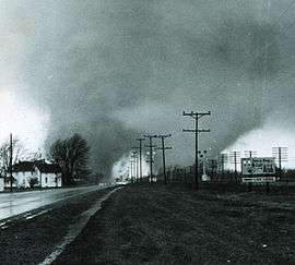
On Palm Sunday, April 11, 1965, a large outbreak of tornadoes struck the Midwest. The most famous pair of tornadoes devastated the Midway Trailer Park (now inside the city limits of Goshen), and the Sunnyside Housing Addition in Dunlap, Indiana, but a smaller F4 tornado also struck neighborhoods on the southeast side of Goshen on the same day. Statewide, 137 Hoosiers died in the storms—55 of them in Elkhart County. Days later, President Lyndon B. Johnson visited the Dunlap site.[15]
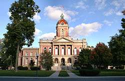
The Goshen Historic district, added in 1983 to the National Registor of Historic Places[16] is bounded by Pike, RR, Cottage, Plymouth, Main, Purl, the Canal, and Second Sts. with the Elkhart County Courthouse at its center.
In April 2006, Goshen was the site for an immigration march. Officials estimated that from 2000 to 3000 people marched from Linway Plaza to the County Courthouse.[17]
For much of its history, Goshen was a "sundown town", forbidding African Americans from living in, or entering, the town, often under threat of violence. In March 2015, the city acknowledged this part of its past, apologizing and saying that it no longer condones such behavior.[18]
The Elkhart County Courthouse, Fort Wayne Street Bridge, Goshen Carnegie Public Library, Goshen Historic District, William N. Violett House, and Violett-Martin House and Gardens are listed on the National Register of Historic Places.[19]
Geography
Goshen is located at 41°34′55″N 85°50′12″W / 41.58194°N 85.83667°W. The Elkhart River winds its way through the city and through a dam on the south side making the Goshen Dam Pond. Rock Run Creek also runs through town. The city is divided east/west by Main Street and north/south by Lincoln Avenue.
According to the United States Census Bureau, the city has a total area of 16.59 square miles (42.97 km2), of which 16.23 square miles (42.04 km2) is land and 0.36 square miles (0.93 km2) is water.[3]
Demographics
| Historical population | |||
|---|---|---|---|
| Census | Pop. | %± | |
| 1850 | 780 | — | |
| 1860 | 2,053 | 163.2% | |
| 1870 | 3,133 | 52.6% | |
| 1880 | 4,123 | 31.6% | |
| 1890 | 6,033 | 46.3% | |
| 1900 | 7,810 | 29.5% | |
| 1910 | 8,514 | 9.0% | |
| 1920 | 9,525 | 11.9% | |
| 1930 | 10,397 | 9.2% | |
| 1940 | 11,375 | 9.4% | |
| 1950 | 13,003 | 14.3% | |
| 1960 | 13,718 | 5.5% | |
| 1970 | 17,871 | 30.3% | |
| 1980 | 19,665 | 10.0% | |
| 1990 | 23,797 | 21.0% | |
| 2000 | 29,383 | 23.5% | |
| 2010 | 31,719 | 8.0% | |
| Est. 2015 | 32,983 | [20] | 4.0% |
2010 census
As of the census[4] of 2010, there were 31,719 people, 11,344 households, and 7,580 families residing in the city. The population density was 1,954.3 inhabitants per square mile (754.6/km2). There were 12,631 housing units at an average density of 778.3 per square mile (300.5/km2). The racial makeup of the city was 78.2% White, 2.6% African American, 0.5% Native American, 1.2% Asian, 14.8% from other races, and 2.7% from two or more races. Hispanic or Latino of any race were 28.1% of the population.
There were 11,344 households of which 36.1% had children under the age of 18 living with them, 47.4% were married couples living together, 13.1% had a female householder with no husband present, 6.3% had a male householder with no wife present, and 33.2% were non-families. 27.4% of all households were made up of individuals and 13.2% had someone living alone who was 65 years of age or older. The average household size was 2.67 and the average family size was 3.23.
The median age in the city was 32.4 years. 27.4% of residents were under the age of 18; 11.3% were between the ages of 18 and 24; 26.1% were from 25 to 44; 20% were from 45 to 64; and 14.9% were 65 years of age or older. The gender makeup of the city was 48.9% male and 51.1% female.
2000 census
As of the census[6] of 2000, there were 29,383 people, 10,675 households, and 7,088 families residing in the city. The population density was 2,227.7 people per square mile (860.1/km²). There were 11,264 housing units at an average density of 854.0 per square mile (329.7/km²). The racial makeup of the city was 83.15% White, 1.53% Black or African American, 0.26% Native American, 1.10% Asian, 0.02% Pacific Islander, 12.00% from other races, and 1.94% from two or more races. 19.33% of the population were Hispanic or Latino of any race.
There were 10,675 households out of which 32.6% had children under the age of 18 living with them, 50.8% were married couples living together, 10.1% had a female householder with no husband present, and 33.6% were non-families. 27.5% of all households were made up of individuals and 12.5% had someone living alone who was 65 years of age or older. The average household size was 2.61 and the average family size was 3.14.
In the city the population was spread out with 25.9% under the age of 18, 12.9% from 18 to 24, 30.0% from 25 to 44, 17.6% from 45 to 64, and 13.6% who were 65 years of age or older. The median age was 32 years. For every 100 females there were 100.6 males. For every 100 females age 18 and over, there were 97.7 males.
The median income for a household in the city was $39,383, and the median income for a family was $46,877. Males had a median income of $32,159 versus $23,290 for females. The per capita income for the city was $18,899. About 6.0% of families and 9.3% of the population were below the poverty line, including 11.8% of those under age 18 and 5.3% of those age 65 or over.
Economy
Industry in Goshen centers around the automotive and RV business. There are automotive component manufacturers like Benteler; firms that build custom bodies onto chassis like Supreme, Independent Protection and Showhauler Trucks. RV manufacturing companies include Dutchmen, Forest River and Keystone.[22]
Government
The government consists of a mayor, a clerk, treasurer and a city council. The mayor and clerk are elected in citywide vote. The city council consists of seven members. Five are elected from individual districts. Two are elected at-large.
Education
Goshen Community Schools serves all of the city that is inside of Elkhart Township. This system consists of seven elementary schools, Goshen Middle School, and Goshen High School.
In 2012, U.S. News & World Report ranked Goshen High School as the 12th best high school in Indiana, as well as in the top 6% of high schools in the entire country.[23]
Small parts of the city of Goshen are covered by several other school districts, including Fairfield Community Schools, Middlebury Community Schools, Concord Community Schools, and WaNee Community Schools.
Goshen College, located on the south side of town, has a current enrollment of approximately 885, with 40% being male, and 60% being female. Tuition and fees for the 2011–2012 year were $25,700.
Transportation
Airport
Goshen Municipal Airport is a public use airport located three nautical miles (6 km) southeast of the central business district of Goshen. It is owned by the Goshen Board of Aviation Commissioners.[24]
Bus
The Interurban Trolley bus connects Goshen to the nearby city of Elkhart and the unincorporated town of Dunlap via Concord and Elkhart-Goshen routes. The routes pass at Elkhart's Amtrak station, allowing passengers to connect to the Capitol Limited and Lake Shore Limited trains. Riders can also transfer to North Pointe route and Bittersweet/Mishawaka route. The former allows riders to connect to Elkhart's Greyhound bus station, while the later connects the riders to the city of Mishawaka and town of Osceola. The Bittersweet/Mishawaka route also allows them to transfer to TRANSPO Route 9 to connect to destinations throughout the South Bend-Goshen metropolitan region and the South Shore Line's South Bend Regional Airport station.
Recreation


Goshen has seven parks and has a few different greenways and trails winding through the city, one of which runs along the old Mill Race and hydraulic canal which was once used to power an old hydroelectric power plant. Plans drawn up in 2005 call for the plant to be reopened and redevelopment to begin along the canal.[25]
The Pumpkinvine Nature Trail runs from Goshen to Middlebury and Shipshewana, along the former Pumpkin Vine Railroad. The trail starts north east of Goshen at Abshire Park. It is one of the recreational highlights of Goshen. Along with the Maple City Greenway and the Millrace trail, they provide many miles of easily accessible trails for walking, running, and biking.
The Elkhart County Fairgrounds are also located in the city, where in late July, the Elkhart County 4-H Fair is held. It is the largest county fair in Indiana and one of the largest 4-H County Fairs in the United States.[26]
The Goshen Air Show is also an annual event that takes place at the Goshen Municipal Airport.[27]
In 2007, Downtown Goshen, Inc., a public-private partnership formed from the merger of Face of the City and the Downtown Action Team, started a First Fridays program. Occurring year round, First Fridays happens on the first Friday of each month with stores open until 9, music and other entertainment, and other events occurring within Goshen's downtown district.
Culture
The south side Wal-Mart is rumored to be the first Wal-Mart in the United States to provide a covered stable for its frequent Amish customers. The Amish built the stable with lumber and other supplies donated by Wal-Mart.[28]
Notable people
US Representatives
- John Harris Baker (1832–1915)
- Ebenezer M. Chamberlain (1805–1861)
- Joseph Hutton Defrees (1812–1885)
Entertainment
- Kate Bolduan, CNN anchor
- James Carew, silent film actor (1876–1938)
- Howard Hawks, film director (1896–1977)
- Kenneth Hawks, film director (1898-1930)
- Philip Proctor, voice-over talent (b. 1940)
- Raymond L. Schrock, screenwriter (1892–1950)
- James C. Strouse, screenwriter
- Jordon Hodges, actor
- Tim Showalter, musician (Strand of Oaks )
Sports
- Rick Mirer, NFL quarterback
- Justin Yoder, soap box racer
- Shek Borkowski, coach of Haiti national soccer team
References
- ↑ "US Gazetteer files: 2010, 2000, and 1990". United States Census Bureau. 2011-02-12. Retrieved 2011-04-23.
- ↑ "Mayor's Office". City of Goshen, IN. Retrieved 6 January 2016.
- 1 2 "Places: Indiana". 2010 Census Gazetteer Files. United States Census Bureau. Retrieved 2012-04-21. External link in
|work=(help) - 1 2 "American FactFinder". United States Census Bureau. Retrieved December 11, 2012.
- ↑ "Population Estimates". United States Census Bureau. Retrieved June 25, 2013.
- 1 2 "American FactFinder". United States Census Bureau. Retrieved 2008-01-31.
- ↑ "US Board on Geographic Names". United States Geological Survey. 2007-10-25. Retrieved 2008-01-31.
- ↑ "Find a County". National Association of Counties. Retrieved 2011-06-07.
- ↑ Purdue Alumni Club of Elkhart County
- ↑ History of Elkhart County, Indiana. Chas. C. Chapman Co. 1881. p. 884.
- ↑ Gannett, Henry (1905). The Origin of Certain Place Names in the United States. Govt. Print. Off. p. 140.
- 1 2 3 The Yankee Exodus: An Account of Migration from New England by Stewart Hall Holbrook University of Washington Press, 1968
- ↑ American Zion: The Old Testament as a Political Text from the Revolution to ... By Eran Shalev, Yale University Press, Mar 26, 2013 ISBN 9780300186925 page 70-71
- 1 2 3 A Twentieth Century History and Biographical Record of Elkhart County, Indiana edited by Anthony Deahl, Lewis Publishing Company, 1905
- ↑ Weather Events: 1965 Palm Sunday Tornado Outbreak Part II: Sunday Evening
- ↑ National Register of Historical Places – INDIANA (IN), Elkhart County
- ↑ http://www.goshen.edu/bulletin/Current_Issue/features/fuerza
- ↑ "A RESOLUTION ACKNOWLEDGING THE RACIALLY EXCLUSIONARY PAST OF GOSHEN, INDIANA, AS A 'SUNDOWN TOWN'". March 2015. Retrieved March 27, 2015.
- ↑ National Park Service (2010-07-09). "National Register Information System". National Register of Historic Places. National Park Service.
- ↑ "Annual Estimates of the Resident Population for Incorporated Places: April 1, 2010 to July 1, 2015". Retrieved July 2, 2016.
- ↑ "Census of Population and Housing". Census.gov. Retrieved June 4, 2015.
- ↑ Goshen Chamber of Commerce – Manufacturers
- ↑ Goshen High School in GOSHEN, IN | Best High Schools | US News
- ↑ FAA Airport Master Record for GSH (Form 5010 PDF). Federal Aviation Administration. Effective May 31, 2012.
- ↑ Microsoft PowerPoint – Goshen River Race Redevelopment Project 91505B.ppt
- ↑ Welcome to the Official Site For Elkhart County, INDIANA
- ↑ http://www.freedomfestgoshen.com
- ↑ "Raising the barn in Amish country". Discount Store News. 1999.
External links
| Wikivoyage has a travel guide for Goshen. |
| Wikisource has the text of a 1911 Encyclopædia Britannica article about Goshen, Indiana. |
- Official website
- Goshen Chamber of Commerce
- Goshen on citydata.com – collection of statistics and graphs of Goshen demographics.
- Pumpkinvine Nature Trail
Municipalities and communities of Elkhart County, Indiana, United States | ||
|---|---|---|
| Cities | ||
| Towns | ||
| Townships | ||
| CDPs | ||
| Unincorporated communities | ||
| Footnotes | ‡This populated place also has portions in an adjacent county or counties | |