Gorongosa National Park
| Gorongosa National Park | |
|---|---|
|
IUCN category II (national park) | |
|
Entrance to Gorongosa National Park | |
 Location in Mozambique | |
| Location |
|
| Coordinates | 18°45′58″S 34°30′00″E / 18.766°S 34.500°ECoordinates: 18°45′58″S 34°30′00″E / 18.766°S 34.500°E |
| Area | 3,770 square kilometres (1,460 sq mi) |

Gorongosa National Park is at the southern end of the Great African Rift Valley in the heart of central Mozambique. The over 4,000 square km park includes the valley floor and parts of surrounding plateaus. Rivers originating on nearby 1863-m Mount Gorongosa water the plain.
Seasonal flooding and waterlogging of the valley, which is composed of a mosaic of different soil types, creates a variety of distinct ecosystems. Grasslands are dotted with patches of acacia trees, savannah, dry forest on sands and seasonally rain-filled pans and termite hill thickets. The plateaus contain miombo and montane forests and a spectacular rain forest at the base of a series of limestone gorges.
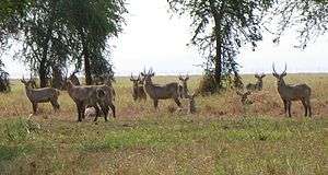
This combination of unique features at one time supported some of the densest wildlife populations in all of Africa, including charismatic carnivores, herbivores and over 500 bird species. But large mammal numbers were reduced by as much as 95% and ecosystems stressed during Mozambique's long civil conflict at the end of the 20th century.
The Carr Foundation/Gorongosa Restoration Project, a U.S. not-for-profit organization, has teamed with the Government of Mozambique to protect and restore the ecosystem of Gorongosa National Park and to develop an ecotourism industry to benefit local communities.
History
Hunting Reserve: 1920–1959
The first official act to protect the Gorongosa region, Portuguese Mozambique, came in 1920, when the Mozambique Company ordered 1,000 square km set aside as a hunting reserve for company administrators and their guests. Chartered by the government of Portugal, the Mozambique Company controlled all of central Mozambique between 1891 and 1940.
In 1935 Mr. Jose Henriques Coimbra was named warden and Jose Ferreira became the reserve's first guide. That same year the Mozambique Company enlarged the reserve to 3,200 square km to protect habitat for Nyala and Black Rhino, both highly prized hunting trophies. By 1940 the reserve had become so popular that a new headquarters and tourist camp was built on the floodplain near the Mussicadzi River. Unfortunately, it had to be abandoned two years later due to heavy flooding in the rainy season. Lions then occupied the abandoned building and it became a popular tourist attraction for many years, known as Casa dos Leões (Lion House).
After the Mozambique Company's charter ended, management of the reserve was transferred to the colonial government. Alfredo Rodriques was appointed Warden, replacing Jose Coimbra. Over the next 14 years Rodrigues initiated the first steps towards banning hunting and establishing a viable tourism business. In 1951 construction began on a new headquarters and other facilities at Chitengo camp, including a restaurant and bar. By the end of the 1950s more than 6,000 tourists were visiting annually and the colonial government had awarded the first tourism concession in the park. In 1955 the Veterinary and Animal Industry Services division of the colonial government assumed control of all wildlife management in Mozambique, including Gorongosa. Gorongosa was named a national park by the Government of Portugal in 1960.
National Park: 1960–1980
Many improvements to the new park's trails, roads and buildings ensued. Between 1963 and 1965 Chitengo camp was expanded to accommodate 100 overnight guests. By the late 1960s it had two swimming pools, a bar and nightclub, a restaurant serving 300-400 meals a day, a post office, a petrol station, a first-aid clinic, and a shop selling local handicrafts.
The late 1960s also saw the first comprehensive scientific studies of the Park, led by Armando Rosinha, Director of Gorongosa, and Kenneth Tinley, an Australian ecologist. In the first-ever aerial survey, Tinley and his team counted about 200 lions, 2,200 elephants, 14,000 buffalo, 5,500 wildebeest, 3,000 zebras, 3,500 waterbuck, 2,000 impala, 3,500 hippos, and herds of eland, sable and hartebeest numbering more than five hundred. The great development of Gorongosa until 1975 was made by Armando Rosinha.
Tinley also discovered that many people and most of the wildlife living in and around the park depended on one river, the Vundudzi, which originated on the slopes of nearby Mount Gorongosa. Because the mountain was outside the park's boundaries, Tinley proposed expanding them to include it as a key element in a "Greater Gorongosa Ecosystem" of about 8,200 square kilometers. He and other scientists and conservationists had been disappointed in 1966 when the government reduced the park's area to 3,770 square kilometers.
Meanwhile, Mozambique was in the midst of a war for independence launched in 1964 by the Mozambique Liberation Front (Frelimo). Fortunately the war had little impact on Gorongosa National Park until 1972, when a Portuguese company and members of the Provincial Volunteer Organization were stationed there to protect it. Even then, not much damage occurred, although some soldiers hunted illegally. In 1974, the Carnation Revolution in Lisbon overthrew the Estado Novo regime. When the new Portuguese authorities decided to abdicate power in their overseas territories, Mozambique became an independent republic. In 1976, a year after Mozambique won its independence from Portugal, aerial surveys of the park and adjacent Zambezi River delta counted 6,000 elephants and about 500 lions.
Civil War: 1981–1994

In 1977, the People's Republic of Mozambique, under the leadership of Samora Machel declared itself a Marxist-Leninist government.[1] A rebel army known as RENAMO sprung up to oppose the new government. Threatened by FRELIMO's new pro-socialist government in Mozambique, neighbouring Rhodesia and South Africa began arming and supplying RENAMO.[2] Once Rhodesia became Zimbabwe in 1980, direct support for RENAMO came from South Africa with the intention of destabilizing Machel's government. Initially dismissed by Machel as a group of "armed bandits", RENAMO's war developed into a full-scale national threat by 1981.[3] In December 1981 the Mozambican National Resistance (MNR, or RENAMO) fighters attacked the Chitengo campsite and kidnapped several staff, including two foreign scientists. The Mozambican Civil War lasted from 1977 to 1994.
The violence increased in and around the Park after that. In 1983 the park was shut down and abandoned. For the next nine years Gorongosa was the scene of frequent battles between opposing forces. Fierce hand-to-hand fighting and aerial bombing destroyed buildings and roads. The park's large mammals suffered huge losses. Both sides in the conflict slaughtered hundreds of elephants for their ivory, selling it to buy arms and supplies. Hungry soldiers shot many more thousands of zebras, wildebeest, buffalos, and other ungulates. Lions and other large predators were gunned down for sport or died of starvation when their prey disappeared.
A cease-fire agreement ended the civil war in 1992 but widespread hunting in the park continued for at least two more years. By that time many large mammal populations—including elephants, hippos, buffalos, zebras, and lions had been reduced by 95 percent. Surveys counted just 15 buffalo, 5 zebra, 6 lions, 100 hippos, 300 elephants and just a handful of wildebeest. Fortunately, the park's spectacular birdlife emerged relatively unscathed.

Post-war: 1995–2003
A preliminary effort to rebuild Gorongosa National Park's infrastructure and restore its wildlife began in 1994 when the African Development Bank (ADB) started work on a rehabilitation plan with assistance from the European Union and the International Union for the Conservation of Nature (IUCN). Fifty new staff were hired, most of them former soldiers. Baldeu Chande and Roberto Zolho, both employed by the Park before the Civil War, returned to take leadership positions. Chande was director of the emergency program and Zolho was wildlife coordinator and warden. Over a five-year period this ADB initiative reopened about 100 kilometers of roads and trails and trained guards to slow illegal hunting.
Restoration: 2004-present
In 2004 the Government of Mozambique and the US-based Carr Foundation agreed to work together to rebuild the park's infrastructure, restore its wildlife populations and spur local economic development—opening an important new chapter in the park's history.
Between 2004 and 2007 the Carr Foundation invested more than $10 million in this effort. During that time the restoration project team completed a 60-square-kilometre (23 sq mi) wildlife sanctuary and reintroduced buffalos and wildebeests to the ecosystem. They also began the reconstruction of Chitengo Safari Camp.
Due to the success of this initial three-year project, the Government of Mozambique and the Carr Foundation announced in 2008 that they had signed a 20-year agreement to restore and co-manage the park. Several thousand visitors now enter the park each year, most staying overnight at Chitengo Safari Camp. Some of these visitors go to see the progress being made in the restoration project, and many others are seeing the park for the first time. The park is open from 6 AM to 6 PM.
In July 2010, the Government of Mozambique made public the decision to increase the area of the Gorongosa National Park and to incorporate Mount Gorongosa (above 700 m) making true an old desire that had been presented in the 60s by the then Park ecologist, Kenneth Tinley. The Government also announced the official establishment of a Park buffer zone of 3,300 square km.
Ecology
Geology
The Park is in a 4,000-square-km section of the Great African Rift Valley system. The Rift extends from Ethiopia to central Mozambique. Massive tectonic shifts began forming the Rift about 30 million years ago. Other warpings, uplifts, and sinkings of the Earth's crust over millennia shaped the plateaus on both sides and the mountain to the west. Mozambique's tropical savanna climate, with an annual cycle of wet and dry seasons, has added another factor to the complex equation: constant change in soil moisture that varies with elevation. The valley is located 21 km west of Mount Gorongosa at 14 m above sea level.
Hydrology

Gorongosa National Park protects a vast ecosystem defined and shaped by the rivers that flow into Lake Urema. The Nhandungue crosses the Barue Plateau on its way down to the valley. The Nhandue and Mucombeze come from the north. Mount Gorongosa contributes the Vunduzi. Several smaller rivers pour down off the Cheringoma Plateau. Together they comprise the Urema Catchment, an area of about 7,850 square km.
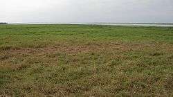
Lake Urema is located in the middle of the valley, about three-quarters of the way down from the Park's northern boundary. The Muaredzi River, flowing from the Cheringoma Plateau, deposits sediments near the outlet of the lake slowing its drainage. This "plug" causes the Urema River to greatly expand in the rainy season. Water that makes its way past this alluvial fan flows down the Urema River to the Pungue and into the Indian Ocean. In the flooded rainy season, water backs up into the valley and out onto the plains, covering as much as 200 square km in many years. During some dry seasons, the lake's waters shrink to as little as 10 square km. This constant expansion and retraction of the floodplains, amidst a patchwork of savanna, woodland, and thickets, creates a complex mosaic of smaller ecosystems that support a greater abundance and diversity of wildlife than anywhere else in the park.
Vegetation
Scientists have identified three main vegetation types supporting the Gorongosa ecosystem’s wealth of wildlife. Seventy-six percent is savanna — combinations of grasses and woody species that favour well-drained soils. Fourteen percent is woodlands — several kinds of forest and thickets. The rest is grasslands subjected to harsh seasonal conditions that prevent trees from growing. All three types are found throughout the system, with many different sub-types and varieties.
Mount Gorongosa has rainforests, montane grasslands, riverine forests along its rivers, and forests and savanna woodlands at lower elevations. Both plateaus are covered with a kind of closed-canopy savanna, widespread in southern Africa, called “miombo,” after the Swahili word for the dominant tree, a member of the Brachystegia genus. About 20 percent of the valley’s grasslands are flooded much of the year.
Mount Gorongosa
More than 2,000 people live on Gorongosa mountain. In July 2010 the government of Mozambique and the Gorongosa Restoration Project (headed by the U.S.–based Carr Foundation) announced that Gorongosa Mountain would be added to the park bringing its total size to 4067 km2.[4] This designation has contributed to an ongoing conflict between long-term residents of the mountain and representatives of the park.[5]
Wildlife

Gorongosa is home to a large diversity of animals and plants—some of which are found nowhere else in the world. This rich biodiversity creates a complex world where animals, plants and people interact. From the smallest insects to the largest mammals, each plays an important role in the Gorongosa ecosystem.
Many of the park's large herbivore populations were greatly reduced by years of war and poaching. However, almost all naturally occurring species—including more than 400 kinds of birds and a wide variety of reptiles—have survived. With effective management and reintroductions of key species, wildlife populations will regain their natural numbers and help restore the park's ecological balance.
References
- ↑ William Finnegan, A Complicated War: The Harrowing of Mozambique, Volume 47 of Perspectives on Southern Africa; University of California Press, 1993. ISBN 0520082664
- ↑ Alex Vines, Renamo: Terrorism in Mozambique, Centre for Southern African Studies, University of York, 1991. ISBN 0253288800
- ↑ Michael Radu, The New Insurgencies: Anti-Communist Guerrillas in the Third World, A Foreign Policy Research Institute book; Transaction Publishers, 1990. ISBN 1412838002
- ↑ "Timeline". Gorongosa National Park.
- ↑ Schuetze, Christy (2015). "Narrative Fortresses: Crisis Narratives and Conflict in the Conservation of Mount Gorongosa, Mozambique". Conservation and Society. 13 (2): 141–153. doi:10.4103/0972-4923.164193.
External links
| Wikivoyage has a travel guide for Gorongosa National Park. |
- Official park web site in several languages, including English
- Pulitzer Center on Crisis Reporting American Greg Carr Describes Why He Is Devoting His Life And Fortune To Gorongosa (Video)
- Explore Gorongosa