Gore Bay, Ontario
| Gore Bay | |
|---|---|
| Town (single-tier) | |
| Town of Gore Bay | |
|
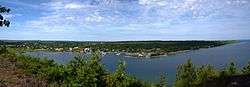
Panorama of Gore Bay and the North Channel. | |
| Motto: Pristine, prosperous, proud. | |
 Gore Bay | |
| Coordinates: 45°55′N 82°28′W / 45.917°N 82.467°WCoordinates: 45°55′N 82°28′W / 45.917°N 82.467°W | |
| Country |
|
| Province |
|
| District | Manitoulin |
| Government | |
| • Type | Town |
| • Mayor | Ron Lane |
| • Governing Body | Corporation of the Town of Gore Bay |
| • MP | Carol Hughes (NDP) |
| • MPP | Michael Mantha (NDP) |
| Area[1] | |
| • Land | 5.27 km2 (2.03 sq mi) |
| Elevation[2] | 193.50 m (634.84 ft) |
| Population (2011)[1] | |
| • Total | 850 |
| • Density | 161.4/km2 (418/sq mi) |
| Time zone | EST (UTC-5) |
| • Summer (DST) | EDT (UTC-4) |
| Postal code | P0P 1H0 |
| Area code(s) | 705 |
| Website | www.gorebay.ca |
Gore Bay is a town on Manitoulin Island in Ontario, Canada. Located on Gore Bay, a bay of Lake Huron's North Channel, it is one of the two incorporated towns of Manitoulin District, of which it is the administrative and government seat.
During the summer months the population and activity of the town flourishes as boaters and tourists from around Ontario and the Great Lakes regions flock to the area. The areas surrounding Gore Bay are quickly becoming popular with cottagers and vacationers during the summer months.
Gore Bay is home to Manitoulin Transport, one of Canada's largest trucking companies.
Notable people
- Major league pitcher Ken Mackenzie.
- National Hockey League player Bobby Burns.
Demographics
| Canada census – Gore Bay, Ontario community profile | |||
|---|---|---|---|
| 2011 | 2006 | 2001 | |
| Population: | 850 (-8.0% from 2006) | 924 (2.9% from 2001) | 898 (-1.0% from 1996) |
| Land area: | 5.27 km2 (2.03 sq mi) | 5.27 km2 (2.03 sq mi) | 5.27 km2 (2.03 sq mi) |
| Population density: | 161.4/km2 (418/sq mi) | 175.4/km2 (454/sq mi) | 170.5/km2 (442/sq mi) |
| Median age: | 50.9 (M: 47.7, F: 52.7) | 45.6 (M: 42.4, F: 47.9) | |
| Total private dwellings: | 414 | 458 | 413 |
| Median household income: | $46,305 | $40,220 | |
| References: 2011[3] 2006[4] 2001[5] | |||
Climate
| Climate data for Gore Bay Airport | |||||||||||||
|---|---|---|---|---|---|---|---|---|---|---|---|---|---|
| Month | Jan | Feb | Mar | Apr | May | Jun | Jul | Aug | Sep | Oct | Nov | Dec | Year |
| Record high humidex | 8.4 | 9.8 | 18.6 | 28.5 | 33.4 | 40.0 | 44.7 | 43.4 | 42.3 | 31.3 | 20.8 | 16.0 | 44.7 |
| Record high °C (°F) | 8.3 (46.9) |
8.3 (46.9) |
16.7 (62.1) |
27.5 (81.5) |
29.5 (85.1) |
31.7 (89.1) |
36.2 (97.2) |
34.4 (93.9) |
33.3 (91.9) |
23.9 (75) |
18.3 (64.9) |
14.3 (57.7) |
36.2 (97.2) |
| Average high °C (°F) | −5.1 (22.8) |
−4.2 (24.4) |
0.9 (33.6) |
8.8 (47.8) |
16.3 (61.3) |
20.7 (69.3) |
24.2 (75.6) |
23.2 (73.8) |
17.7 (63.9) |
11.3 (52.3) |
4.7 (40.5) |
−1.4 (29.5) |
9.8 (49.6) |
| Daily mean °C (°F) | −10.0 (14) |
−9.3 (15.3) |
−3.9 (25) |
3.9 (39) |
10.8 (51.4) |
15.4 (59.7) |
19.1 (66.4) |
18.5 (65.3) |
13.6 (56.5) |
7.7 (45.9) |
1.6 (34.9) |
−5.3 (22.5) |
5.2 (41.4) |
| Average low °C (°F) | −14.8 (5.4) |
−14.3 (6.3) |
−8.7 (16.3) |
−1.1 (30) |
5.3 (41.5) |
10.0 (50) |
13.9 (57) |
13.7 (56.7) |
9.4 (48.9) |
4.0 (39.2) |
−1.5 (29.3) |
−9.2 (15.4) |
0.6 (33.1) |
| Record low °C (°F) | −36.9 (−34.4) |
−36.5 (−33.7) |
−30.6 (−23.1) |
−20.6 (−5.1) |
−5.6 (21.9) |
−7.3 (18.9) |
5.6 (42.1) |
2.3 (36.1) |
−2.0 (28.4) |
−5.0 (23) |
−22.8 (−9) |
−30.5 (−22.9) |
−36.9 (−34.4) |
| Record low wind chill | −46.8 | −44.1 | −37.0 | −26.6 | −10.0 | −4.7 | 5.0 | 1.6 | −5.9 | −12.2 | −27.3 | −44.7 | −46.8 |
| Average precipitation mm (inches) | 53.7 (2.114) |
35.7 (1.406) |
64.9 (2.555) |
63.5 (2.5) |
67.2 (2.646) |
66.1 (2.602) |
52.0 (2.047) |
75.0 (2.953) |
86.3 (3.398) |
88.2 (3.472) |
85.5 (3.366) |
70.8 (2.787) |
808.9 (31.846) |
| Average rainfall mm (inches) | 11.7 (0.461) |
4.8 (0.189) |
37.7 (1.484) |
50.6 (1.992) |
66.6 (2.622) |
66.1 (2.602) |
52.0 (2.047) |
75.0 (2.953) |
86.3 (3.398) |
86.3 (3.398) |
62.4 (2.457) |
25.5 (1.004) |
625.0 (24.606) |
| Average snowfall cm (inches) | 67.1 (26.42) |
47.3 (18.62) |
34.5 (13.58) |
14.1 (5.55) |
0.7 (0.28) |
0 (0) |
0 (0) |
0 (0) |
0 (0) |
2.0 (0.79) |
29.0 (11.42) |
72.6 (28.58) |
267.3 (105.24) |
| Average precipitation days (≥ 0.2 mm) | 18.4 | 12.6 | 12.4 | 12.2 | 11.3 | 11.5 | 9.4 | 11.2 | 12.8 | 13.9 | 15.2 | 18.5 | 159.3 |
| Average rainy days (≥ 0.2 mm) | 2.7 | 2.0 | 6.2 | 10.0 | 11.0 | 11.5 | 9.4 | 11.2 | 12.8 | 13.6 | 10.4 | 5.1 | 105.9 |
| Average snowy days (≥ 0.2 cm) | 18.2 | 12.7 | 8.8 | 4.0 | 0.39 | 0 | 0 | 0 | 0 | 0.96 | 7.6 | 16.2 | 68.7 |
| Source: Environment Canada[2] | |||||||||||||

View from East Bluff Lookout onto Gore Bay.
See also
References
- 1 2 "Gore Bay census profile". 2011 Census of Population. Statistics Canada. Retrieved 2012-02-24.
- 1 2 Environment Canada — , accessed 28 February 2012
- ↑ "2011 Community Profiles". Canada 2011 Census. Statistics Canada. July 5, 2013. Retrieved 2012-02-24.
- ↑ "2006 Community Profiles". Canada 2006 Census. Statistics Canada. March 30, 2011. Retrieved 2012-02-24.
- ↑ "2001 Community Profiles". Canada 2001 Census. Statistics Canada. February 17, 2012. Retrieved 2012-02-24.
External links
 |
Gore Bay (North Channel) | | ||
| Gordon/Barrie Island | |
Gordon/Barrie Island | ||
| ||||
| | ||||
| Gordon/Barrie Island |
This article is issued from Wikipedia - version of the 8/7/2016. The text is available under the Creative Commons Attribution/Share Alike but additional terms may apply for the media files.