Gordon Island
| Native name: <span class="nickname" ">Isla Gordon | |
|---|---|
|
Gordon Island, seen from the Beagle Channel | |
 Gordon Island | |
| Geography | |
| Coordinates | 54°58′S 69°35′W / 54.967°S 69.583°WCoordinates: 54°58′S 69°35′W / 54.967°S 69.583°W |
| Adjacent bodies of water | Beagle Channel, Pacific ocean |
| Area | 591 km2 (228 sq mi) |
| Coastline | 228.3 km (141.86 mi) |
| Highest point | 1548 |
| Administration | |
| Region | Magallanes |
| Province | Antártica Chilena |
| Commune | Cabo de Hornos |
| Additional information | |
| NGA UFI=-883298 | |
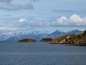
Gordon Island (Spanish: Isla Gordon) is an island in the Tierra del Fuego archipelago located between the Tierra del Fuego (Isla Grande) and the Hoste Island. It divides the Beagle Channel in two arms, the Nordwest arm or Pomar Channel and the Southwest arm.
At the east end of the island is located the lighthouse Punta Divide.
See also
-
 Media related to category:Islands of Chile at Wikimedia Commons
 - List of islands of Chile
- Cabo de Hornos
External links
- Islands of Chile @ United Nations Environment Programme
- World island information @ WorldIslandInfo.com
- South America Island High Points above 1000 meters
- Ministerio de Obras Públicas de Chile (2012), "Maps of all regions of Chile", Cartas camineras 2010 in 200 dpi and 70 dpi resolution available (jpg and pdf) (Maps) (in Spanish), Government of Chile, archived from the original on 4 September 2012, retrieved 20 April 2013
This article is issued from Wikipedia - version of the 11/14/2016. The text is available under the Creative Commons Attribution/Share Alike but additional terms may apply for the media files.