Gomshall railway station
| Gomshall | |
|---|---|
 | |
| Location | |
| Place | Gomshall |
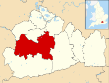
| Local authority | Guildford |
| Grid reference | TQ089478 |
| Operations | |
| Station code | GOM |
| Managed by | Great Western Railway |
| Number of platforms | 2 |
| DfT category | F2 |
|
Live arrivals/departures, station information and onward connections from National Rail Enquiries | |
| Annual rail passenger usage* | |
| 2010/11 |
|
| 2011/12 |
|
| 2012/13 |
|
| 2013/14 |
|
| 2014/15 |
|
| History | |
| Key dates | Opened 20 August 1849 |
| Original company | Reading, Guildford and Reigate Railway |
| Pre-grouping | South Eastern Railway |
| Post-grouping | Southern Railway |
| National Rail – UK railway stations | |
| * Annual estimated passenger usage based on sales of tickets in stated financial year(s) which end or originate at Gomshall from Office of Rail and Road statistics. Methodology may vary year on year. | |
|
| |
Gomshall railway station serves the village of Gomshall in Surrey, England. The station, and all trains serving it, are operated by Great Western Railway. It is on the North Downs Line.
History
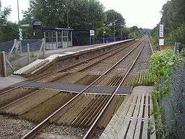
Gomshall station was originally called "Gomshall and Shere", as it also serves the nearby village of Shere. It has been unmanned since 1967. The station is 35 miles 21 chains (56.7 km) from Charing Cross, and has two platforms, which can each accommodate a three-coach train.[1]
Accident
Services
The typical off-peak service (from December 2006) is one train every two hours between Reading and Redhill (extended to Gatwick Airport on Sundays).[3]
| Preceding station | |
Following station | ||
|---|---|---|---|---|
| Chilworth | Great Western Railway North Downs Line |
Dorking West | ||
Gallery
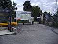 Station entrance
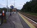 Platform 1
References
- ↑ Yonge, John (November 2008) [1994]. Jacobs, Gerald, ed. Railway Track Diagrams 5: Southern & TfL (3rd ed.). Bradford on Avon: Trackmaps. map 24A. ISBN 978-0-9549866-4-3.
- ↑ Trevena, Arthur (1980). Trains in Trouble. Vol. 1. Redruth: Atlantic Books. p. 18. ISBN 0-906899-01-X.
- ↑ GB eNRT May 2016 Edition, Table 148 (Network Rail)
Coordinates: 51°13′08″N 0°26′31″W / 51.219°N 0.442°W
This article is issued from Wikipedia - version of the 5/26/2016. The text is available under the Creative Commons Attribution/Share Alike but additional terms may apply for the media files.