Gojal
Gojal, also known as Gojal Valley, is a valley situated in the far north of Pakistan. It borders Pakistan and China at Khunjerab Pass and Afghanistan at Chipurson valley. It is the largest tehsil of the Gilgit-Baltistan region of Pakistan.
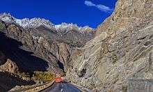
Gojal is a series of large and small valleys sharing borders with Hunza in the south, China in the north-east and Afghanistan in the north-west. Shishkat is the first village of Gojal. Except for the Shimshal, Misgar and Chipursan valleys, all the villages of Gojal can be seen from the Karakorum Highway (KKH), which crosses Gojal, entering China at the Khunjerab Pass.
History
The valleys and villages of Gojal were settled over time by people from surrounding regions. In the opinion of most researchers , Kirghiz nomads initially used the areas in upper Gojal as winter pastures. It is said that later on when Wakhis migrated from Wakhan to this region. It is very difficult to determine when the Wakhis settled in Gojal. However, it is narrated that the earlier Wakhi migrated from Wakhan and settled in the Yishkuk (Chipursun) valley, Hussaini and later the Boiber areas of Moorkun village. It is also narrated that when Hunza was under the Central Government of Gilgit the Ishkook settlement was wealthy and paid cattle and other dairy products to the Raja of Gilgit. As Hunza emerged as an independent state during the early 15th century so it can be inferred that different valleys in upper Gojal were inhabited by the Wakhi speaking migrants prior to the emergence of the Hunza state. Later, the oral history holds, a catastrophic flood destroyed the Ishkook settlement during the 18th century.
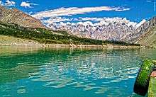
Since 2010, parts of the valley have been inundated by the 27 km long Attabad Lake.
Gulmit - The Tehsil Headquarters
Gulmit is the administrative headquarters of the Gojal Tehsil, in the upper Hunza region. Gulmit is a centuries-old historic town, with mountains, peaks and glaciers. It is a tourist spot and has many hotels, shops and a museum. It is located 2,408 meters (7,900 feet) above the sea level. Gulmit consists of small hamlets called Kamaris, Odver, Dalgiram, Laksh, Kalha, Shawaran, Khor Lakhsh, Chamangul and Goze. Gulmit is home to around 4,000 people, all of them Wakhi-speakers and followers of the Ismaili sect of Shia Islam.
Before 1974, when Hunza was a state, Gulmit used to be the Summer Capital of the state. After the abolition of the state it became the Tehsil's seat of government. The oldest intact house in Gulmit is more than six centuries old.
There are six Jamaat-khanas or religious community centres in Gulmit. One notices their presence in every ward of the village. The old Summer Palace of Mir of Hunza stands at the northern edge of Gulmit's historic Polo Ground. Old mosques, now used as libraries, also adorn the beautiful physique of Gulmit valley.
Among new buildings constructed by the government in Gulmit are Tehsil Headquarters, Federal Government's Boys High School, Civil Hospital, Diamond Jubilee Girls Middle School and Government Girls Higher Secondary School.
Al- Amyn Model School, a community-based organization, has a beautiful building standing next to the Health Center of Aga Khan Health Services.
Settlement of Passu
Passu is located with 125 km from Gilgit on the KKH near the border of China and is surrounded by the mountains of the Karakoram range. Its neighbourhood also includes two large glaciers: Batura and Passu glacier. It is one of the most dangerous places to live in due to the continuous threat of floods and has been flooded four times in the past. Passu is also one of the most ancient villages in the area. According to Archeologists, the first human settlement in the area dates back to 3000BC or 5000BC. There are many ancient rock carvings of ibex and zebra on several rocks, showing that ibexes have been around in the valley for many millennia, but the area no longer houses zebras. the only other wildlife here are snow leopards and yaks. In the second settlement era, Chinese Buddhists lived here. The buddhists of Gandahara, Swat, Gilgit, and Passu travelled from via this valley to go to China. Records of this settlement and subsequent migration are found in Karga Gilgit and Khurramabad Passu. The third settlement in the history of this valley is the Islamic era. Islam came to this area in the ninth century when Arab soldiers and traders ventured to these parts of the world. Quranic verses were etched in the mountains around the valley during this era. The fourth era was also Islamic, which was settled here in the 18th century. This time, the area boasted a vibrant populace of 315 families. However, this village was destroyed by natural disaster with a landslide and the nearby river was blocked. Only a few families remained safe by the landslide. This village was destroyed once again in 1964 when the population was forced into migration by the flooding of the Shimshal river and erosion around the river bank. This time around too, the village had some 300 houses. The majority of Passu's native population recognises its ancestor as a man named Quli, who had come from Wakhan in the 15th century. In his memory, the people of Passu are also known as Quli-kuts or kutor. The quli-kuts tribe has also inhabited Karimabad, Murtazabad and many other villages of central Hunza. The quli-kuts in central Hunza later adopted the Burushu way of life and now speak the Burushaski language. Most of the families migrated to chapurson and Khyber. Among the current inhabitants of Passu are seven families: the Alvi, Mughani, Dinali, Sakhi, Quba, and Hadab. The latest figures put the population of Passu around 1000.
Settlement of Ghulkin
Ghulkin Village is located in Gojal, upper Hunza. It is reached by following the Karakoram Highway (KKH)
140 km north of Gilgit. This trip takes 3–4 hours by van. From a turn-off just beyond Gulmit, a winding jeep track leads upwards for 3 km, until the ground flattens out and the first houses of the village come into view.
Ghulkin occupies the site of an old glacier fed lake, which has been silted up by continuous sedimentation. Many of the 140 traditional dwellings that constitute Ghulkin village are arranged in a circular form, facing the one-time shores of the lake, creating a wonderfully communal atmosphere. The central area now supports several dwellings and fields, including a strip of land often used as a cricket pitch.
There is no accurate historical record of the origin of the village, though it is estimated to be around 700 years old. According to local folklore, there were settlements here while the lake was still in existence, this area being used as pastureland in summer. The name is derived from two words of the local Wakhi dialect, 'Ghulk', meaning 'well' and 'kin', meaning 'whose'. Being an area of low rainfall, the most vital requirement is water for irrigation, livestock, drinking and domestic use. Khawaja Ahmed, and Ismaili Muslim who came here with the Mir of Hunza, asked him for land. After the Mir agreed, Khawaja Ahmed mobilised the people of the area to construct a water-channel to irrigate the land. This made cultivation possible and the Ismaili settlement flourished. Now small scale health and educational institutions, electricity and water-sully facilities are available in the village. Through the involvement of capacity-building NGOs, there is also a handicraft production centre and opportunities for other vocational training. The Jammatkhana, the central religious institution for all Ismaili Muslims, holds a strong position in the community. Apart from its religious functions, it provides a central location for community meetings, festivals, celebrations, resolution of disputes and other community activity. In Upper Hunza, winters are long and can become bitterly cold. Snowfall brings with it the Himalayan ibex, descending in search of grass under the snow cover. Summers are hot in the north, though more pleasant than the harsh temperatures in summer are around 30 °C. In winter the temperature remains below freezing point, further dropping at night
Hussaini

Hussaini village is one of the oldest settlements of Wakhi people in the Gojal valley. Hussaini is surrounded with the Karakoram Highway, Hussaini Glacier and the Khunjarav River.
People: The residents of Hussaini Gojal are ethnically Wakhi Tajik and speak Xik Wakhi language.
Religion: The people of Hussaini Gojal are followers of the Ismaili sect of Islam.
Tourist Attractions:
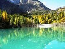
Hussaini Suspension Bridge, Borith Lake, Zarabad and Sultan e Shahtalib (decades old shrine of a saint) are famous tourist attractions of the Hussaini village of Gojal valley.
Geography
Geographically Gojal is located between 70 latitude and 61 and is spread over an area of 8,500 km² of land, at an elevation ranging from 2,340m to 4,877m, above the sea level.
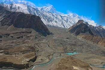
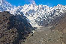
Gojal is a mountainous region forming the western part of the Karakoram and Eastern Pamir mountain range. This area also hosts the 56 km long Batura glacier the third longest of Pakistan (after Hispar and Biafo).
The region is home to lofty ice-capped peaks, roaring rivers, lush green pastures and long glaciers.
Villages
The main villages of this district include: Shishkat (now Nazeemabad also called Trapur), Gulmit, Ghulkin, Husseini (older names Sisoni/Ghusani), Borith, Passu, Shimshal, Khyber, Ghalapan, Morkhoon, Jamalabad, Gircha, Sost, Khudaabad, Misgar, Yarzerech, Raminj, Kirmin, Khill, Rasht, Shersabz, Ispenj, Shitmerg and Zoodkhoon.
Administration
Gulmit, the winter-capital of the then Hunza state until 1974, is the main town (tehsil headquarters) and seat of government, while Sost is the border check-post and gateway for Pakistan-China overland trade. The entire region is governed by bureaucrats, sitting in Gilgit. Law and order is supported by two police stations and a magistrate.
Poets
Gojal Valley is home to some amazing poets. Among the poets are Nazir Ahmad Bulbul, Saif uddin Saif, Rehmat Ullah Mushfiq, Afzal Karim and many more. Most of these poets write in Wakhi language.
Tourist sites
Gulmit Valley
As the largest village of the Gojal Valley, Gulmit has a lot to offer to the tourists. One of the most important tourist sites in the village include the Gulmit Tower peak, which has yet to be climbed. The Shutubar Meadows located at the foot of the Gulmit Tower are a must-see place, if you are visiting the valley.
The ruins of the Ondra Fort, located above the Ondra hills, offer glimpses into the history of the region. The Ondra fort used to serve as a safe haven for the earlier communities that were threatened by invaders from the North and South, alike. The fort is in ruins due to neglect by the government authorities and other bodies working for cultural development. The Ondra fort is located at a vintage point, offering beautiful views of the areas from Passu to Ayeenabad. The spot is perfect for photography.
Lovers of rock-climbing will love being in an area located at a short walk from Kamaris, where the lofty and naturally sliced huge peaks offer opportunities for learning and enjoying rock-climbing.
A museum located within the Marcopolo Hotel has some important artifacts from the past, reflecting the entire region's history and traditions.
Passu Valley
Passu is known for the Batura Glacier and Passu Glacier, and Mount Tupopdon at the north end of the villages. Inspired by its unique structural attributes, tourists have promoted the peak by giving it new names. Some call it "Passu Cones" and others "Passu Cathedral". Mount Tupopdon is the most photographed peak of the region.
With its diverse places, people and customs, Passu is the mixing bowl of ancient civilization and dream of nature lovers, is well known for its contrasting landscapes of the world. From times, immemorial, the village has served as a mountainous resort, situated in the spectacular Karakoram Mountains on the old silk route 150 km from Gilgit in the west banks of Hunza River and border on China. Many adventurers, eco-tourists, historians and nature lovers visit the area.
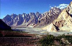
Passu is a high mountainous region, with nothing below 2,500 metres; specific mountain peaks include Passu (7284 metres), Shisper (7611 metres), Batura (7785 metres), and the most remarkable is Passu cathedral peak at 6500 metres. Lakes and Glaciers
Gojal is also famous for its natural beauty. There are different Lakes and charming Glaciers. Borith Lake and Shimshal is famous among them, Borith Glacier, Passu Glacier, Batura glacier, Pamir Glacier and there are numbers of glaciers which are still unexplored. Attabad lake has its own beauty.
Shimshal Valley ŠIMŠAL DIYOR
Shimshal's inaccessibility does not stop tourists from visiting the area as there is a great deal of natural beauty.
Chipursan Valley
Chipursan valley is a network of small and large villages close to the border of Afghanistan and parts of China. Historians say that this was the earliest human settlement of the entire region. Chipursan is home to the Irshad Pass that connects Gojal Valley with Badakshan. Also located in the vicinity of Chipursan Valley are Ishkoman, Buroghil and Yasin valleys.
Misgar Valley
Misgar valley is a narrow human settlement located very close to the Chinese border, almost parallel to Chipursan. Misgar is home to the Qalamdarchi Fort Fort of the Naked Saint. This "fort" was created by the British rulers of Hunza Valley to keep an eye on the movement of Soviet troops and spies in the region. Kilik and Mintika Passes were used by traders, troops, travellers and spies in the past. This fort is in a dilapidated condition. Parts of the fort are being used by Jawans of Pakistan Army.