Goat Peak
| Goat Peak | |
|---|---|
 Goat Peak lookout tower | |
| Highest point | |
| Elevation | 7,001 ft (2,134 m) [1] |
| Coordinates | 48°37′56″N 120°24′14″W / 48.632163986°N 120.403987653°WCoordinates: 48°37′56″N 120°24′14″W / 48.632163986°N 120.403987653°W [2] |
| Geography | |
| Location | Okanogan County, Washington, U.S. |
| Parent range | North Cascades |
| Topo map | USGS Big Snow Mountain |
Goat Peak is a 7,001-foot (2,134 m) peak in the North Cascades of Washington, United States. The summit offers broad views of the Methow River valley, as well as many of the other prominent cascade peaks including glaciated Silver Star Mountain. A working US Forest Service fire lookout is located on the summit. The trailhead for Goat Peak is accessible from Forest Road 52, 1 mile (1.6 km) southeast of Mazama, starting at an elevation of 5,600 feet (1,700 m).
This Goat Peak is one of three summits with the same name in Washington state.[3]
References
- ↑ "Goat Peak". ListsOfJohn.com. Retrieved November 14, 2012.
- ↑ "Goat Peak lookout tower". NGS data sheet. U.S. National Geodetic Survey.
- ↑ "Goat Peak, Washington". Geographic Names Information System, U.S. Geological Survey. Retrieved November 14, 2012.
External links
- "Goat Peak". Geographic Names Information System. United States Geological Survey. Retrieved November 14, 2012.
- "Goat Peak". Western Trail Association. Retrieved November 14, 2012.
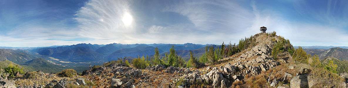
360° panorama on a September afternoon near the summit of Goat Peak in the northern Cascades in Washington State. There are views of the Methow River Valley and the greater Cascade Range including glaciated Silver Star Mountain. Goat Peak Lookout is prominent on the right side. High ice clouds create sun dogs on either side of the sun.
This article is issued from Wikipedia - version of the 1/2/2016. The text is available under the Creative Commons Attribution/Share Alike but additional terms may apply for the media files.