Goaribari is an island in southern Papua New Guinea. It is located in Gulf Province within the Gulf of Papua. During high tides, parts of the island are inundated. The vegetation is thick rainforest.
Headhunting was evidenced by the discovery of thousands of skulls in village houses and the longhouse in the early 20th century. In 1901, two ministers and ten missionary students were murdered and cannibalized by island natives.[2]
Geography
Goaribari Island measures about 5.8 miles (9.3 km) in east-west direction. Risk Point is the eastern extreme and southward of it there is a sand bank, nearly dry at low water, which extends nearly 3 miles (4.8 km) off the southeast side of the island. The island is covered with tall mangroves.
The island is a formation at the delta of the Kikori and Omari Rivers, which is just about 1 metre (3 ft 3 in) above sea level; it consists of mud formation, sedimentary in nature, with localized Aird Hills. During very high tides (king tides during storm events), parts of the island become inundated. This has caused some deltaic villages to be relocated to higher ground.
History
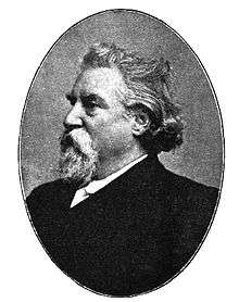
Left:
James Chalmers who was murdered on the island; Right: Memorial for James Chalmers
In 1901, the missionary Harry Dauncey found 10,000 skulls in the island’s longhouses. In the same year, the Revs. James Chalmers and Oliver F. Tomkins, together with ten missionary students, were murdered with stone implements and cannibalized by the natives of this island on 8 April,[2] at Dopima village when they tried to preach to the natives and convert them; their bones were hung as trophies.
Following the massacre of the white missionaries, an Australian Royal Commission was called in 1904 to inquire into the scandal. This mission was led by Judge Christopher Stansfield Robinson. The object was to apprehend a native called Lake who was allegedly involved in the murders and who had refused to return the mortal remains of the missionaries for a Christian burial.
The mission also wanted to train a few natives as a police force to serve the island. A clash ensued between the natives who stormed the Australian ship Merrie England. The clash was implemented without forethought, turning violent. Guns were used on the natives. As many as eight were killed and many were injured. There were no major injuries to the Australians.
During this reprisal raid Rev. H. M. Dauncey reported that between 4 and 700 skulls were found in various village houses, and nearly 10,000 skulls were counted in the longhouse and burnt during this raid. The mission considered the natives to be savages as they greased their body for cover instead of wearing clothing. Professor Matthew R. Keller believes the commission viewed the population of the island as a different biological species. As a consequence of the villagers' massacre, Robinson shot himself and was replaced as Chief Judicial Officer by Hubert Murray.
1924 floods
In 1924, floods and erosion of large tracts of coastal land resulted in the people of Kirawa village abandoning their homes and shifting to other villages in the Goaribari district. As a result, there are only two villages that remain on the island – Goare in the west (pop. 38) and Dopima in the east (pop. 62), which are also subject to frequent flooding. Some archaeological remains of Otoia village remain, while parts have been eroded by the Kikori River's delta channel. Pile dwellings are common as most of the land is barely above high water (of spring tides) which makes most of the island almost uninhabitable.
Culture
The Kerewo people live in the northwestern region of the island. The language spoken by the people is linked to Kiwai. Their ethnic identity is similar to those of the Fly River delta. Men have worn pubic protection crafted from a Melo shell.
The Muguru ceremony that natives of the island conduct is similar to the one held by Kiwai people which is conducted at the club house decorated by dracaena leaves and a dracaena branch is stuck into the waist bands of the novices. When a skull is captured then also the dracaena is hung on the club house. On the top of the hill growth of crotons is noted.
Flora
The wildlife is dominated by a tropical wet rainforest. Flora includes Nipa and coconut palms.
Governance
Goaribari is part of West Kikori Rural LLG (Local Level Government) Area in Kikori District of Gulf Province.
References
- 1 2 Prendergast, Patricia A. "Chalmers, James (1841–1901)". An initiative of the National Centre of Biography at the Australian National University. Australian Dictionary of Biography.
Bibliography
- Great Britain. Hydrographic Dept (1908). Pacific Islands ... (Public domain ed.). Hydrographic office, Admiralty.
- Goldman, Laurence (1 January 1999). The Anthropology of Cannibalism. Greenwood Publishing Group. ISBN 978-0-89789-597-2.
- Haberle, Simon G. (1 January 2012). Peopled Landscapes: Archaeological and Biogeographic Approaches to Landscapes. ANU E Press. ISBN 978-1-921862-72-4.
- Keller, Matthew Raymond (2008). Re-drawing the Color Line: How National Commissions Explained Collective Violence in the 20th Century. ProQuest. ISBN 978-1-109-06165-9.
- Maiden, Peter (2003). Missionaries, Headhunters and Colonial Officers: British New Guinea and the Goaribari Affray 1860-1907. Rockhamption, Qld: Central Queensland University Press. ISBN 9781876780296. OCLC 614841210.
- McKinnon, Rowan; Carillet, Jean-Bernard; Starnes, Dean (2008). Papua New Guinea & Solomon Islands. Lonely Planet. ISBN 978-1-74104-580-2.
- Morrissey, Di (6 January 2012). Scatter the Stars. Macmillan Australia. ISBN 978-1-4668-1001-3.
- Neich, Roger; Pereira, Pandora Fulimalo (1 January 2004). Pacific Jewelry and Adornment. University of Hawai'i Press. ISBN 978-0-8248-2882-0.
- Riesenfeld, Alphonse (1950). The Megalithic Culture of Melanesia. Brill Archive. GGKEY:Z1UP2DH6D7D.
|
|---|
|
| 1901–1920 |
|---|
| | 1901–1910 | | 1901–1905 |
- to inquire into and report upon the arrangements made for the transport of troops returning from service in South Africa in the S.S. "Drayton Grange" (1902)
- on sites for the seat of government of the Commonwealth (1903)
- on the Bonuses for Manufactures Bill (1903–1904)
- on the butter industry (1904–1905)
- on the Navigation Bill (1904–1906)
- on the affray at Goaribari Island, British New Guinea, on the 6th of March, 1904 (1904)
- on customs and excise tariffs (1904–1907)
- on old-age pensions (1905–1906)
- on the tobacco monopoly (1905–1906)
|
|---|
| | 1906–1910 |
- on ocean shipping service (1906)
- British New Guinea—Royal Commission of inquiry into the present conditions, including the method of government, of the Territory of Papua, and the best means of their improvement (1906–1907)
- on secret drugs, cures, and foods (1906–1907)
- on postal services (1908–1910)
- on insurance (1908–1910)
- on stripper harvesters and drills (1908–1909)
- on Tasmanian customs leakage (1910–1911)
|
|---|
|
|---|
| | 1911–1920 | | 1911–1912 |
- on the sugar industry (1911–1912)
- on the pearl-shelling industry (1912–1916)
- on the fruit industry (1912–1914)
|
|---|
| | 1913–1914 |
- to inquire into certain charges against Mr. Henry Chinn (1913)
- on Northern Territory railways and ports (1913–1914)
- on powellised timber (1913–1914)
- upon the Commonwealth electoral law and administration (1914–1915)
- on meat export trade (1914)
- on food supplies and trade and industry during the war (1914)
|
|---|
| | 1915–1916 |
- on mail services and trade development between Australia and the New Hebrides (1915)
- on Liverpool Military Camp, New South Wales (1915)
- on the charges made by D. L. Gilchrist concerning the construction of the western section of the Kalgoorlie to Port Augusta Railway (1916)
- to inquire into and report upon certain charges against the Administrator and other officers of the Northern Territory Administration (1916)
- on Federal Capital Administration (1916–1917)
|
|---|
| | 1917–1918 |
- on Java and the East Indies, Singapore and the Straits Settlements (1917–1918)
- on Navy and Defence Administration (1917–1919)
- on the war—Australian Imperial Force. Report as to number of members fit for active service and number of reinforcements and enlistments required (1918)
- on Public Service administration, Commonwealth of Australia (1918–1920)
- upon the public expenditure of the Commonwealth of Australia with a view to effecting economies (1918–1921)
- on taxation of leasehold estates in Crown lands (1918–1919)
- on the basic wage (1919–1920)
|
|---|
| | 1919–1920 |
- on the sugar industry (1919–1920)
- on industrial troubles on Melbourne wharfs (1919–1920)
- on late German New Guinea (1919–1920)
- to inquire into complaints by the munition worker passengers to Australia by the transport "Bahia Castillo" (1919)
- on Northern Territory Administration (1919–1920)
- on taxation (1920–1923)
- on the increase of the selling price of coal (1920)
|
|---|
|
|---|
|
|
|
| 1921–1940 |
|---|
| | 1921–1930 | | 1921–1922 |
- on the matter of uniform railway gauge (1921)
- on pillaging of ships' cargoes (1921)
- on Cockatoo Island Dockyard (1921)
- upon the loyalty to the British Crown of German Nationals resident in Australia whose property is liable to a charge created by the Treaty of Peace Regulations made under the Treaty of Peace (Germany) Act 1919–1920 (1921)
|
|---|
| | 1923–1924 |
- on the circumstances attending the supposed loss at sea of the steamship "Sumatra" (1923)
- in connection with sugar purchases by the Commonwealth through Mr. W. E. Davies in September and October, 1920 (1923–1924)
- in connection with joinery supplied to the War Service Homes Commissioner in March, 1920 (1923–1924)
- on the Navigation Act (1923–1925)
- on national insurance (1923–1927)
- on the method for determining the unimproved value of land held under Crown leases (1924–1925)
- on the assessment of war service disabilities (1924–1925)
- to inquire into extracts from the reports in Parliamentary Debates of speeches made by Mr. Scullin in the House of Representatives on 7 and 19 August 1924, in relation to land tax matters (1924–1925)
- on the finances of Western Australia, as affected by Federation (1924–1925)
|
|---|
| | 1925–1926 |
- on health (1925–1926)
- on Norfolk Island affairs (1926)
- on certain matters in connexion with the British Phosphate Commission (1926)
|
|---|
| | 1927–1928 | |
|---|
| | 1929–1930 |
- on the coal industry (1929)
- to inquire into allegations affecting members of the Parliamentary Joint Committee of Public Accounts in connexion with claims made by broadcasting companies against the Commonwealth Government (1930)
|
|---|
|
|---|
| | 1931–1940 | | 1931–1935 |
- on Jacob Johnson (1931)
- on performing rights (1932–1933)
- on taxation (1932–1934)
- on mineral oils and petrol and other products of mineral oils (1933–1935)
- on the wheat, flour and bread industries (1934–1936)
- to inquire into and report upon the circumstances associated with the retirement of Lieutenant-Commander Alan Dermot Casey from the Royal Australian Navy (1934)
- to inquire into the monetary and banking systems at present in operation in Australia (1935–1937)
|
|---|
| | 1936–1940 |
- on doctors' remuneration for national insurance service and other contract practice (1938)
- regarding the contract for the erection of additions to the General Post Office, Sydney (1939)
|
|---|
|
|---|
|
|
|
| 1941–1960 |
|---|
| | 1941–1950 |
- to inquire into and report upon the contract or contracts with Abbco Bread Co. Pty. Limited for the supply of bread to the Department of the Army, and other matters (1941)
- to inquire into circumstances under which certain public monies were used and to whom, and for what purposes such moneys were paid (1941)
- an inquiry into a statement that there was a document missing from the official files in relation to "The Brisbane Line" (1943)
- to inquire into and report upon certain transactions of the Sydney Land Sales Control Office, and the Canberra Land Sales Control Office of the Treasury (1947)
- to inquire into certain transactions in relation to timber rights in the Territory of Papua-New Guinea (1949)
|
|---|
| | 1951–1960 |
- on the Port Augusta to Alice Springs Railway (1951–1952)
- on television (1953–1954)
- on espionage (1954–1955)
|
|---|
|
|
|
| 1961–1980 |
|---|
| | 1961–1970 | |
|---|
| | 1971–1980 | | 1971–1975 |
- Aboriginal Land Rights Commission (1973–1974)
- Australian Post Office Commission of inquiry (1973–1974)
- of Inquiry into land tenures (1973–1976)
- on petroleum (1973–1976)
- of Inquiry into the maritime industry (1973–1976)
- Independent Inquiry into Frequency Modulation Broadcasting (1973–1974)
- of Inquiry into transport to and from Tasmania (1974–1976)
- on Australian Government Administration (1974–1976)
- on human relationships (1974–1978)
- on intelligence and security (1974–1977)
- into alleged payments to maritime unions (1974–1976)
- to inquire into and report upon certain incidents in which Aborigines were involved in the Laverton area (1975–1976)
- on Norfolk Island (1975–1976)
|
|---|
| | 1975–1980 |
- of Inquiry into drugs (1977–1980)
- of Inquiry into matters in relation to electoral redistribution Queensland, 1977 (1978)
- of Inquiry into the efficiency and administration of hospitals (1979–1981)
- of Inquiry into the viability of the Christmas Island phosphate industry (1979–1980)
- on the activities of the Federated Ship Painters and Dockers Union (1980–1984)
|
|---|
|
|---|
|
|
|
| 1981–2000 |
|---|
| | 1981–1990 | | 1981–1985 |
- of Inquiry into Drug Trafficking (1981–1983)
- into the activities of the Australian Building Construction Employees' and Builders Labourers' Federation (1981–1982)
- into Australian meat industry (1981–1982)
- of Inquiry into the activities of the Nugan Hand Group (1983–1985)
- on the use and effects of chemical agents on Australian personnel in Vietnam (1983–1985)
- on Australia's security and intelligence agencies (1983–1985)
- of Inquiry into compensation arising from social security conspiracy prosecutions (1984–1986)
- into British nuclear tests in Australia (1984–1985)
- of inquiry into alleged telephone interceptions (1985–1986)
|
|---|
| | 1986–1990 | |
|---|
|
|---|
| | 1991–2000 |
- of Inquiry into the Australian Secret Intelligence Service (1994–1995)
- of Inquiry into the leasing by the Commonwealth of accommodation in Centenary House (1994)
- of Inquiry into the relations between the CAA and Seaview Air (1994–1996)
|
|---|
|
|
|
|
|
|