Glienicke/Nordbahn
| Glienicke/Nordbahn | ||
|---|---|---|
|
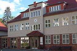
Town Hall | ||
| ||
 Glienicke/Nordbahn | ||
Location of Glienicke/Nordbahn within Oberhavel district  | ||
| Coordinates: 52°37′59″N 13°19′59″E / 52.63306°N 13.33306°ECoordinates: 52°37′59″N 13°19′59″E / 52.63306°N 13.33306°E | ||
| Country | Germany | |
| State | Brandenburg | |
| District | Oberhavel | |
| Government | ||
| • Mayor | Dr. Hans G. Oberlack (FDP) | |
| Area | ||
| • Total | 4.60 km2 (1.78 sq mi) | |
| Population (2015-12-31)[1] | ||
| • Total | 12,155 | |
| • Density | 2,600/km2 (6,800/sq mi) | |
| Time zone | CET/CEST (UTC+1/+2) | |
| Postal codes | 16548 | |
| Dialling codes | 033056 | |
| Vehicle registration | OHV | |
| Website | www.glienicke.eu | |

Glienicke/Nordbahn is a municipality in the Oberhavel district, in Brandenburg, Germany. It is located right north of Berlin.
Situation
Glienicke/Nordbahn is located on the northern outskirts of Berlin. The addition "Nordbahn" (Northern Railway) is based on the proximity to the 19th century-built railway line Berlin-Stralsund, the Prussian Northern Railway. The town is bordered to the south and west by the district Reinickendorf of Berlin (localities Frohnau, Hermsdorf (Berlin) and Lübars) and Schönfließ, Mühlenbecker Land. Between 1961 and 1990 was situated at the eastern border of the Berlin Wall. The village is a typical Angerdorf (meadow) of the Mark Brandenburg. The highest point of the village is the "Langeberg" with 55 m.ü.NN.
From Glienicke there are 10 Miles (17 km) to Oranienburg, 25 Miles (44 km) to Potsdam, 180 Miles (270 km) to Stralsund near the Baltic See, 180 Miles (271 km) to Hamburg and 90 Miles (150 km) to Cottbus.
History
- First mentioned as Glyneck in 1412.
- Devastated during the War of Thirty Years.
- Reestablished from 1670.
- During the Cold War, Glienicke shared its borders with the former West Berlin, and so between 1961 and 1990 it was separated from it by the Berlin Wall.
- After the reunification of Germany, Glienicke developed as a preferred suburb of Berlin.
Demography
After (East) Berlin, Glienicke/Nordbahn is the most densely populated municipality of any type in what was formerly East Germany, ahead of third-place Eichwalde (both are classified as rural municipalities, or Gemeinden), and well ahead of larger municipalities with city ("Stadt") status, such as Leipzig, Halle, and Dresden.
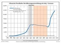 Development of Population since 1875 within the Current Boundaries (Blue Line: Population; Dotted Line: Comparison to Population Development of Brandenburg state; Grey Background: Time of Nazi rule; Red Background: Time of Communist rule)
 Recent Population Development (Blue Line) and Forecasts
|
|
|
|
Pictures
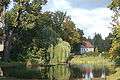 Central Pond.
 Lutheran Church.
 Central Pond at Night.
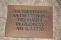 Memorial for the local opening of the Berlin Wall on March 3, 1990.
 Chapel of the Cemetery.[3]
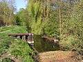 Kindelfließ-rivulet on the southern rim of Glienicke with the remains of the "water wall" that separated Glienicke (GDR) from West-Berlin.
Politics
The Council consists of 22 members.
(Election: September 28, 2008)
Mayors
- 1990 - 1994 Karin Röpke
- 1994 - 2010 Joachim Bienert
- 2010 - Dr. Hans G. Oberlack
Personalities
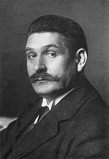
- Uwe Barschel, (1944-1987), former Prime Minister of Schleswig-Holstein, was born in Glienicke.
- Fali Ramadani, (born 1963), player agent, his company named Lian Sports has its headquarter in the city
- Adolf von Trotha (1868-1940), Admiral of the Imperial Navy and Admiralty, honorary citizen of, buried in the cemetery of the parish Glienicke / Nordbahn
- Gustav Bauer (1870-1944), 1919-1920 Chancellor, lived from 1940 to 1944 in Glienicke / Nordbahn, in the cemetery of the parish Glienicke / Nordbahn buried
- Walter Felsenstein (1901-1975), director, had his residence in Glienicke / Nordbahn
Freemen
- Adolf von Trotha (1868-1940), Admiral of the Imperial Navy and Admiralty
- Erich Schwabe (1909-2015), military leader of the volunteer fire department Glienicke / Nordbahn (1964–1976),[4][5] oldest firefighter of Brandenburg[6]
References
- ↑ "Bevölkerung im Land Brandenburg nach amtsfreien Gemeinden, Ämtern und Gemeinden 31. Dezember 2015 (Fortgeschriebene amtliche Einwohnerzahlen auf Grundlage des Zensus 2011)". Amt für Statistik Berlin-Brandenburg (in German). 2016.
- ↑ Detailed data sources are to be found in the Wikimedia Commons.Population Projection Brandenburg at Wikimedia Commons
- ↑ http://www.ekg-glienicke.de/dpl6/taxonomy/term/4
- ↑ http://www.glienicke.eu/presse/oga/archiv/2011/januar/29_01_02.html
- ↑ http://www.glienicke.eu/presse/maz/archiv/2011/januar/29_01_02.html
- ↑ https://www.glienicke.eu/portal/meldungen/ehrenbuerger-erich-schwabe-gestorben-904005034-22451.html?rubrik=904000002
External links
- Official site (German)
Towns and municipalities in Oberhavel | ||
|---|---|---|