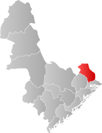
Gjerstad
| Gjerstad kommune | |||
|---|---|---|---|
| Municipality | |||
| |||
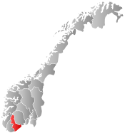
 Gjerstad within Aust-Agder | |||
| Coordinates: 58°53′33″N 8°57′24″E / 58.89250°N 8.95667°ECoordinates: 58°53′33″N 8°57′24″E / 58.89250°N 8.95667°E | |||
| Country | Norway | ||
| County | Aust-Agder | ||
| District | Sørlandet | ||
| Administrative centre | Gjerstad | ||
| Government | |||
| • Mayor (2007) | Rune Hagestrand (H) | ||
| Area | |||
| • Total | 322.14 km2 (124.38 sq mi) | ||
| • Land | 308.36 km2 (119.06 sq mi) | ||
| • Water | 13.78 km2 (5.32 sq mi) | ||
| Area rank | 263 in Norway | ||
| Population (2010) | |||
| • Total | 2,478 | ||
| • Rank | 298 in Norway | ||
| • Density | 8/km2 (20/sq mi) | ||
| • Change (10 years) | -1.2 % | ||
| Demonym(s) |
Gjersdøl Gjersdøling[1] | ||
| Time zone | CET (UTC+1) | ||
| • Summer (DST) | CEST (UTC+2) | ||
| ISO 3166 code | NO-0911 | ||
| Official language form | Neutral | ||
| Website |
www | ||
|
| |||

Gjerstad is a municipality in Aust-Agder county, Norway. It is located in the traditional region of Agder, in the southeastern part of the county, along the border with Telemark county.[2]
General information
The parish of Gjerstad was established as a municipality on 1 January 1838 (see formannskapsdistrikt). The borders have not changed since.
Name
The municipality (originally the parish) is named after the old Gjerstad farm (Old Norse: Geirreksstaðir), since the first church was built there. The first element is the genitive case of the male name Geirrekr (Debatable! There is no known example of Geirr - Geirrek as a first name from the periode when the farm supposedly got its name. A more likely explanation of Gjerstad is from Geirr - spear. There are over 25 Gjerstad-farms i Norway.) and the last element is staðir which means "homestead" or "farm".[3]
Coat-of-arms
The coat-of-arms is from modern times. They were granted on 18 April 1986. The arms show three knives as a symbol for the smithies and knife makers in the municipality. Knife making has long been a local tradition for which the village is well known.[4]
History
Gjerstad was, until about 1650, named Vissedal, from vidr-ser-dalr: wood-sea-dale, a very proper description of the area. Gjerstad has been inhabited from the Stone Age and Viking Age through modern times. Agriculture has long been important, and until only decades ago the more marginal outfields in Upper Gjerstad were still utilized. Forestry also provided an important historic economic contribution, and logs were driven on rivers and streams in the municipality. To aid log transport by floating, numerous dams were constructed. Eikeland Ironworks were a significant contribution to the economy as well.
Geography
Gjerstad municipality has numerous glacially formed features, including a U-shaped valley, tarns and lakes. It is bordered in the north by Nissedal, Telemark and Drangedal, Telemark; in the east by Kragerø, Telemark; in the south by Risør, Aust-Agder; and in the southwest by Vegårshei, Aust-Agder.
Attractions
- The remains of Eikeland Ironworks can still be seen in the upper valley. Gjerstad was famous for its beautiful handmade knives and the coat-of-arms recognizes this heritage.
- Horga was a former pagan place of sacrifice which was destroyed by Olav Trygvason, during the introduction of Christianity to Gjerstad. It lies 300 metres (980 ft) from Holmen Gård.
- Holmen Gård in Gjerstad (Norwegian: Holmen Gård i Gjerstad) is the site of a former farm. It is now a Norwegian national center for folk art and handicraft. The site has been awarded the St. Olaf's Rose (Olavsrosa), a hallmark for Norwegian Heritage which designates especially distinguished places. The site also offers accommodation, cuisine, exhibitions, hiking trails, and memorials associated with Norwegian mathematician Niels Henrik Abel who grew up in Gjerstad.[5][6]
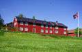 Hovedhuset på Holmen Gård i Gjerstad, Foto: ©Torgrim Landsverk.
Notable residents
Niels Henrik Abel (1802–1829), Norwegian mathematician, was the son of Søren Georg Abel. His grandfather, Hans Mathias Abel, served as minister to Gjerstad municipality from 1785 to 1804. His father became minister in Gjerstad in 1804, so Abel spent his boyhood in the rectory at Gjerstad. Abel spent his last months at the nearby Froland Verk.
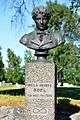 Abel Memorial close to the local Church in Gjerstad. Foto: ©Torgrim Landsverk.
References
- ↑ "Navn på steder og personer: Innbyggjarnamn" (in Norwegian). Språkrådet. Retrieved 2015-12-01.
- ↑ "Gjerstad municipality". gonorway.com. Retrieved February 5, 2016.
- ↑ Rygh, Oluf (1905). Norske gaardnavne: Nedenes amt (in Norwegian) (8 ed.). Kristiania, Norge: W. C. Fabritius & sønners bogtrikkeri. p. 11.
- ↑ Norske Kommunevåpen (1990). "Nye kommunevåbener i Norden". Retrieved 2008-10-03.
- ↑ "Holmen Gård". Olavsrosa. Retrieved February 5, 2016.
- ↑ "Niels Henrik Abel bust at Gjerstad". Holmen Gård in Gjerstad. Retrieved February 5, 2016.
External links
| Wikimedia Commons has media related to Gjerstad. |
| Look up Gjerstad in Wiktionary, the free dictionary. |
- Municipal fact sheet from Statistics Norway
 Aust-Agder travel guide from Wikivoyage
- Welcome to Holmen Gård in Gjerstad
- Gjerstad.org (Norwegian)
- Culture in Gjerstad on the map (Norwegian)