Jendemsfjellet
| Jendemsfjellet | |
|---|---|
 | |
| Highest point | |
| Elevation | 633 m (2,077 ft) |
| Prominence | 555 m (1,821 ft) |
| Coordinates | 62°48′03″N 07°02′37″E / 62.80083°N 7.04361°ECoordinates: 62°48′03″N 07°02′37″E / 62.80083°N 7.04361°E |
| Geography | |
 Jendemsfjellet Location in Møre og Romsdal | |
| Location | Fræna, Møre og Romsdal, Norway |
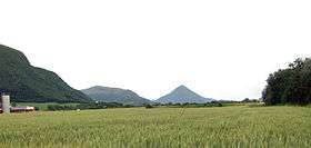
Jendemsfjellet is a mountain in Fræna Municipality in Møre og Romsdal county, Norway. The cone-shaped mountain is located just northeast of the villages of Jendem and Hollingen (on the municipal border with Aukra Municipality), southeast of the small island of Vågøy, and southwest of the village of Aureosen. The 633-metre (2,077 ft) mountain sits just east of Julsundet strait and south of Frænafjorden.[1]
References
- ↑ "Jendemsfjellet, 633m". WestCoastPeaks.com. Retrieved 2010-11-14.
This article is issued from Wikipedia - version of the 5/30/2015. The text is available under the Creative Commons Attribution/Share Alike but additional terms may apply for the media files.