Girnar
| Mount Girnar ગિરનાર પર્વત | |
|---|---|
|
Girinagar Revatak Parvata | |
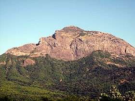 Girnar Hill from Bhavnath | |
| Highest point | |
| Elevation | 1,031 m (3,383 ft) |
| Listing | List of Indian states and territories by highest point |
| Coordinates | 21°29′41″N 70°30′20″E / 21.49472°N 70.50556°ECoordinates: 21°29′41″N 70°30′20″E / 21.49472°N 70.50556°E |
| Geography | |
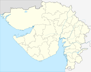
Girnar, also known as Girinagar or Revatak Pravata, is a group of mountains in the Junagadh District of Gujarat, India, situated near Junagadh.
Older than the Himalayas,[1] Girnar, the mountain and its range are considered sacred. It is an important pilgrimage site for both Jains and Hindus, who gather here during the Girnar Parikrama festival. Girnar is significant among Shiva devotees for the mystic space-time of the mountain range with the known presence and turnover of different sects of Sadhu Babas, Nath sect, different Jain Tirthankaras to Girnar, its typical flora and fauna, and the Maha Shivratri fair. Girnar hosts a number of temples and some historical spots across its range. Amidst the lush green Gir Forest, the mountain range serves as the hub of religious activity.
For Hindus this place is considered holy as Dattatreya stayed there.
Also, this place is associated with the death of the mighty Yavana warrior Kalayavana in Dwaparyug. Lord Shri Krishna lured Kalayavana into the cave where the great king of Tretayug, Muchukunda, one of the forefathers of Lord Shri Rama was in a deep slumber of thousands of years after helping Devas in an epic war with Asuras. Contemplating an absolutely undisturbed sleep he was given a boon that anyone who dared to disturb his sleep would get burnt to ashes immediately. Fast forward to Dwaparyug, in the darkness deep inside the cave, Kalayavan mistakenly wakes up Muchukunda from his sleep, and sure to his boon Kalayavan was decimated into ashes instantaneously. Then Muchukunda was delighted to see Lord Shri Krisha there, who was none other than Lord Vishnu. This story is very popular in Srimad Bhagavata. Lord Damodar here is considered as Adhipati of Girnar Kshetra.This place is very holy for Vaishnavaits. Notwithstanding the story though, today Mount Girnar is even more popular as a Shaiva and Siddha Kshetra.
This mountain was considered holy to Buddhists as well.[2]
According to tradition, Pavhari Baba, who had an immense influence on Swami Vivekananda was first initiated into the mysteries of practical yoga on the top of mount Girnar.
History
The mountain Girnar is older than the Himalayas and the Jain temples upon it are amongst the most ancient in the country; it is the Moksha Sthali of Shri Neminath Bhagwaan (22nd tirthankera of Jains). It is 3666 feet high, and is one of the most remarkable mountains in India. From the city of Junagarh, which is at an altitude of barely 351 feet only the top of Mount Girnar can be seen, as it has in front of it lower hills, of which Jogniya, or Laso Pawadi, 2527 feet; Lakhshman Tekri, Bensla, 2290 feet high; and Datar, 2779 feet high, are the principals.[3]
Girnar was anciently called Raivata or Ujjayanta, sacred amongst the Jains to Neminath, the 22nd Tirthankar, and a place of pilgrimage before the days of Ashoka, 250 BCE.[3]
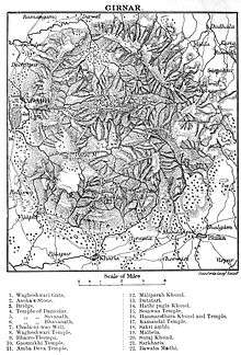
Trek of Girnar
Initial trek

The base of the mountain, known as Girnar Taleti, is about 4 km east of the center of Junagadh. There are temples and other sacred places all along this stretch.
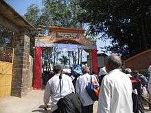
The traveller, in order to reach Girnar Taleti from Junagadh city, will pass through the Wagheshwari or Vagheshwari Gate [Girnar Darwaza], which is close to the Uparkot fort area, Easterly.
At about 200 metres from the gate, to the right of the road, is the Temple of Wagheshwari (Upale Vagheshwari maa), which is joined to the road by a causeway about 150 yards long. An ancient Verai Mata mandir and a modern Gayatri Shakti Peeth mandir are nearby.
About a furlong beyond this is a stone bridge, and just beyond it on the right are the Ashoka's Major Rock Edicts.[3] The edicts are inscribed high up on a large, domed mass of black granite measuring roughly 20 feet x 30 feet. The inscription is in Brahmi script.[4]
On leaving Ashoka's edicts, the route crosses the handsome bridge over the Sona-rekha, which here forms a fine sheet of water over golden sand, then passes a number of temples, at first on the left bank of the river and then on the right, to the largest of the temples. This is dedicated to Damodar, a name of Krishna, from Dam, a rope, because by tradition his mother in vain attempted to confine him with a rope when a child. The reservoir, Damodar Kund, at this place is accounted very sacred.[3]
Next is an old shrine of Bhavnath, a form of Shiva, close to Girnar Taleti; Mrigi kund and Sudharshan lake are nearby.
Most persons who are not active climbers will probably proceed up the mountain in a swing doli from Taleti. A long ridge runs up from the west, and culminates in a rugged scarped rock, on the top of which are the temples. Close to the old shrine is a well called the Chadani vav.[3]
The paved way begins just beyond this and continues for two-thirds of the ascent. The first resthouse, Chadia Parab, is reached, 480 feet, above the plain; and the second halting-place at Dholi-deri, 1000 feet above the plain. From here the ascent becomes more difficult, winding under the face of the precipice to the third resthouse, 1400 feet up. The path turns to the right along the edge of a precipice, which is very narrow, so that the doli almost grazes the scarp, which rises perpendicularly 200 feet above the traveller. On the right is seen the lofty mountain of Datar, covered with low jungle. At about 1500 feet there is a stone dharmsala, and from this there is a fine view of the rock called the Bhairav-Thampa, "the terrific leap," because devotees used to cast themselves from its top, falling 1000 feet or more.[3]
At 2370 feet above Junagadh the gate of the enclosure known as the Deva Kota, or Ra Khengar's Palace, is reached.[3]
Jain temples
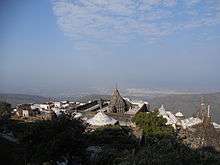

On entering the gate, the large enclosure of the temples is on the left, while to the right is the old granite temple of Man Singh, Bhoja Raja of Kutch, and farther on the much larger one of Vastupala. Built into the wall on the left of the entrance is an inscription in Sanskrit. Some 16 Jain temples here form a sort of fort on the ledge at the top of the great cliff, but still 600 feet below the summit. The largest temple is the Neminath temple, standing in a quadrangular court 195 x 130 feet. It was built from 1128 to 1159. It consists of two halls (with two porches, called by the Hindus mandapams), and a shrine, which contains a large black image of Neminath, the 22d Tirthankar. Around the shrine is a passage with many images in white marble. Between the outer and inner halls are two shrines. The outer hall has two small raised platforms paved with slabs of yellow stone, covered with representations of feet in pairs called padukas, which represent the 2452 feet of the Gandharas, first disciples of Tirthankaras. On the west of this is a porch overhanging the perpendicular scarp. On two of the pillars of the mandapam are inscriptions dated 1275, 1281, and 1278—dates of restoration. The enclosure is nearly surrounded inside by 70 cells, each enshrining a marble image, with a covered passage in front of them lighted by a perforated stone screen.
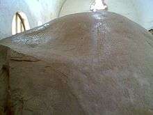
The principal entrance was originally on the east side of the court, but it is now closed, and the entrance from the court in Khengar's Palace is that now used. There is a passage leading into a low dark temple, with granite pillars in lines. Opposite the entrance is a recess containing two large black images; in the back of the recess is a lion rampant, and over it a crocodile in bas-relief. Behind these figures is a room from which is a descent into a cave, with a large white marble image which is mostly concealed by priests. It has a slight hollow in the shoulder, said to be caused by water dropping from the ear, whence it was called Amijhara, "nectar drop."[3] Neminath is said to have attained Moksha from Girnar so this place is frequently noted in Jain literature.[5]
In the North porch are inscriptions which state that in Samwat 1215 certain Thakurs completed the shrine, and built the Temple of Ambika.
After leaving this there are three temples to the left that on the south side contain a colossal image of Rishabha Deva, the first Tirthankar, exactly like that at Palitana temples, called Bhim-Padam. On the throne of this image is a slab of yellow stone carved in 1442, with figures of the 24 Tirthankars.[3]
Opposite this temple is a modern one to Panchabai. West of it is a large temple called Malakavisi or Meravasi, sacred to Parshwanath, built in the 15th century. North of this is another temple of Parshwanath, which contains a large white marble image canopied by a cobra, whence it is called Sheshphani, an arrangement frequently found in the South India but uncommon in the North India. It bears a date of 1803. The last temple to the north is Kumarpal's temple, built by Solanki king Kumarpal, which has a long open portico on the west. It appears to have been destroyed by the Muslims, and restored in 1824 by Hansraja Jetha. These temples are along the west face of the hill, and are all enclosed.[3]
Outside to the north is the Bhima Kunda, a tank 70 feet by 50 feet, in which Hindus bathe. Immediately behind the temple of Neminath is the triple one temple, Vastupala-Tejpala temple, erected by the brothers Tejapala and Vastupala (built in 1177), who also built the Dilwara Temples on Mount Abu. The plan is that of three temples joined together. The shrine has a blue black image of Mallinath, the 19th Tirthankar. Farther north is the temple of Samprati Raja, This temple is probably one of the oldest on the hill, dating to 1158. Samprati is said to have ruled at Ujjain in the end of the third century BCE, and to have been the son of Kunala, Ashoka's third son.[3]
Further trek
.jpg)


South of this, and 200 feet above the Jain temples, is the Gaumukhi Shrine, near a plentiful spring of water.[3]
From it the crest of the mountain (3330 feet) is reached by a steep flight of stairs. Here is an ancient temple of Amba Mata, which is much resorted to by newly married couples (2nd / 3rd tonk of Jains). The bride and bridegroom have their clothes tied together, and attended by their male and female relations, adore the goddess and present cocoa-nuts and other offerings. This pilgrimage is supposed to procure for the couple along continuance of wedded bliss.[3]
To the east not far off, are the three rocky spires of the Gorakhnath, 5th tonk of Jains (Nirvaan sthali of Shri Neminath Bhawaan) presently known as Guru Dattatreya, and then Kalika Peaks.[3] The paduka, the footprints, of Guru Dattartreya Bhagwaan is the topmost shrine.
On the summit of the Datar Peak (2779 feet) is a small shrine, and from it a very beautiful view. The hill is held sacred by Muslims and Hindus alike.[3]
Festivals
As it is holy place as Siddha Kshetra of Jains, for the moksha of Shri Neminath Bhagwaan (22th tirthanker), Jains celebrate Moksha Kalyanak of Neminath Bhagwaan on AAshad Shukla satam (7). Moksha Sthali of Shri Neminath Bhagwaan is 5th tonk (presently known as dattratraya as per Hindu monks).
The main event for Hindus is the Maha Shivaratri fair held every year on the 14th day of the Hindu calendar month of Magha. At least 1 million pilgrims visit the fair to participate in pooja and parikrama of Girnar hill. The procession begins at Bhavnath Mahadev Temple at Bhavnath. It then proceeds onwards to various akharas of various sects of sadhus, which are in Girnar hill from ancient times. The procession of sadhus and pilgrims ends again at Bhavnath temple after visiting Madhi, Malavela and Bara Devi temple. The fair begins with hoisting of fifty-two Gaja long flag at Bhavnath Mahadev temple. This fair is the backbone of the economy of Junagadh, as more than ten lakh pilgrims who visit the fair generate a revenue of 250 million in only five days.[6][7][8]
References
- ↑ Ibrahim, Farhana. "The Region and Its Margins Re-appropriations_of_the_Border_from_MahaGujarat to Swarnim Gujarat". Academia.edu. Academia.edu. Retrieved 10 March 2013.
- ↑ Sketch of the life of Pavhari Baba : Volume 4
- 1 2 3 4 5 6 7 8 9 10 11 12 13 14 15 Murray, John (1911). "A handbook for travellers in India, Burma, and Ceylon". Internet Archive. pp. 155–157. Retrieved 28 January 2016.
- ↑ Keay, John (2000). India, a History. New York, United States: Harper Collins Publishers. pp. 129–131. ISBN 0-00-638784-5.
- ↑ M A Dhaky, Jitendra B Shah, સાહિત્ય શિલ્પ અને સ્થાપત્યમાં ગીરનાર, L D Indology, 2010
- ↑ "બાવન ગજની ધ્વજાનાં આરોહણ સાથે આજથી મહાશિવરાત્રિ મેળો Shivaratri fair begins today with hoisting of 52 gaja dwaja". Sandesh. 16 February 2012. Retrieved 22 August 2012.
- ↑ "ગિરનાર ઃ લીલી પરિક્રમા ઃ પરકમ્મા Girnar - Lili Parikrama". Gujarat Samachar. 4 August 2012. Retrieved 22 August 2012.
- ↑ "જૂનાગઢની આર્થિક કરોડરજજુ શિવરાત્રિનો મેળો : પાંચ દિવસમાં રૂ.રપ કરોડનો લાભ Junagadh's economic backbone - Girnar Shivaratri fair - generates income of 25 crores in five days". Sandesh. 18 February 2012. Archived from the original on 2007-12-23. Retrieved 22 August 2012.
| Topics | 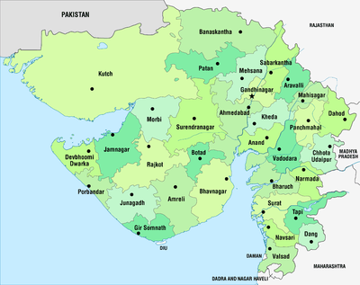 | |
|---|---|---|
| Regions of Gujarat |
| |
| Districts | ||
| Major cities | ||
| Ecoregions | ||
| Economy |
| |
| ||