Gig Harbor, Washington
| Gig Harbor, Washington | |
|---|---|
| town | |
 | |
| Nickname(s): The Maritime City | |
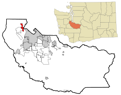 Location of Gig Harbor, Washington | |
| Coordinates: 47°19′37″N 122°35′11″W / 47.32694°N 122.58639°WCoordinates: 47°19′37″N 122°35′11″W / 47.32694°N 122.58639°W | |
| Country | United States |
| State | Washington |
| County | Pierce |
| Area[1] | |
| • Total | 5.96 sq mi (15.44 km2) |
| • Land | 5.95 sq mi (15.41 km2) |
| • Water | 0.01 sq mi (0.03 km2) |
| Elevation | 36 ft (11 m) |
| Population (2010)[2] | |
| • Total | 7,126 |
| • Estimate (2015)[3] | 8,753 |
| • Density | 1,197.6/sq mi (462.4/km2) |
| Time zone | Pacific (PST) (UTC-8) |
| • Summer (DST) | PDT (UTC-7) |
| ZIP codes | 98329, 98332, 98335 |
| Area code(s) | 253 |
| FIPS code | 53-26735 |
| GNIS feature ID | 1512239[4] |
| Website | www.cityofgigharbor.net |
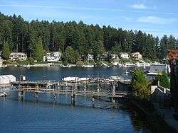
Gig Harbor is the name of both a bay on Puget Sound and a city on its shore in Pierce County, Washington, United States. The population was 7,126 at the 2010 census.
Gig Harbor is one of several cities and towns that claim to be "the gateway to the Olympic Peninsula". Due to its close access to several state and city parks, and historic waterfront that includes boutiques and fine dining, it has become a popular tourist destination. Gig Harbor is located along State Route 16, about six miles (10 km) from its origin at Interstate 5, over the Tacoma Narrows Bridge. A 1.2 billion dollar project to add a second span to the bridge was completed in 2007.[5] During off-peak traffic times, Tacoma can be reached in five minutes and Seattle in just under an hour.
Based on per capita income, Gig Harbor ranks 49th of 522 areas in the state of Washington to be ranked.
History
During a heavy storm in 1840, Captain Charles Wilkes brought the Captain's gig (small boat) into the harbor for protection. Later, with the publication of Wilkes 1841 Map of the Oregon Territory, he named the sheltered bay Gig Harbor.
1867 brought fisherman Samuel Jerisich to the Gig Harbor area, along with many other immigrants from Sweden, Norway, and Croatia. The town was platted in 1888 by Alfred M. Burnham.[6]
Gig Harbor was officially incorporated on July 12, 1946. Commercial fishing, boat building, and logging dominated the economy until the construction of the first Tacoma Narrows Bridge in 1940. Until then, the primary method of transportation between Gig Harbor and the economic center of nearby Tacoma was by steamship. Starting in 1836 steamships started plying the waters of Puget Sound and quickly developed into what was eventually dubbed "The Mosquito Fleet." Gig Harbor, isolated from Tacoma and Seattle by Puget Sound and the Tacoma Narrows, could not be reached by automobile or horseback except via a very long and arduous trip south around Puget Sound and Hammersly Inlet. The boom was to be short lived as the first bridge collapsed just months after it was completed. The resource demands of World War II prevented another bridge from being built until 1950. Between the time when the first bridge collapsed and when the second bridge was completed, a state run ferry service delivered drivers directly into downtown Gig Harbor. Remains of the ferry dock can still be seen just outside the mouth of the harbor at the southeast end of Harborview Drive. The area has been turned into a small park where the public can see a panoramic view of the Cascade Mountains, Pt. Defiance, and Mt. Rainier.
After the completion of the replacement bridge in 1950, Gig Harbor and the surrounding area quickly began to develop as a suburb of neighboring Tacoma. First the area saw substantial residential development as families retreated from Tacoma in favor of the tree-lined neighborhoods and waterfront lots available on the Gig Harbor Peninsula. What had once been summer cabins became primary residences for people who commuted daily over the bridge to Tacoma. Medium-sized housing development sprang up across the peninsula. The 1980s and 1990s saw substantial retail development near State Route 16 to service the growing residential population, shifting the economic center of Gig Harbor out of downtown. For some time, city leaders were unsure how to handle the growth while maintaining the character of the city. Ultimately, the city decided to aggressively annex the surrounding rural areas and convert them into high-density commercial and housing districts, forever changing the rural character of the area but assuring that little new development happens in the historic downtown area, preserving its history and charm. By the 1970s, local merchants had begun actively promoting the downtown area for its historic value, and tourism became prominent on the list of economic engines in Gig Harbor. Today, downtown Gig Harbor is a very active place for tourists with shopping, dining, and recreation on every block. The last large swath of undeveloped waterfront property at the south end of downtown, was recently developed into the headquarters of the Russell Foundation, named for George Russell, founder of Russell Financial.
Today, despite a long history of boat building, very little manufacturing exists in Gig Harbor. The only remaining boatbuilder in Gig Harbor is Gig Harbor Boatworks, which builds rowing and sailing dinghies in classic style using modern materials. Until recently, Tiderunner Boats maintained a manufacturing facility at the north end of the bay. The historic Skansie boatyard is now primarily a maintenance facility for yachts and pleasure craft. The Glein/Eddon/Gig Harbor boatyard was recently purchased by the city after spending many years sitting idle. The city intends to use it as a working waterfront museum.
Commercial fishing is still of great cultural, if somewhat lesser economic, importance to Gig Harbor, and many commercial fishing boats make Gig Harbor their home port. Most, however, do not rely on Puget Sound to gather their catch, rather, finding it more profitable to venture north to Alaska to fish in the summer. Gig Harbor's fishing fleet still gathers the first weekend in June (during the Maritime Gig Festival) in the center of the bay for the annual Blessing of the Fleet ceremony. In recent years, due to the dwindling number of remaining fishing boats, pleasure craft have been allowed to participate in the ceremony, somewhat lessening its authenticity, but increasing its visibility and participation.
A new Tacoma Narrows Bridge has been built alongside the existing bridge and opened July 2007, doubling past capacity. With it will come new economic challenges and benefits for the city of Gig Harbor and the surrounding community.

Skansie Shipyard
In 1905, the Skansie brothers were the first in the area to build a gasoline-powered fishing boat. They did so at first by refitting boats with a gasoline-powered engine. Usually the motors were quite small, between 6 and 8 horsepower; the Skansie brothers originally used a 7-horsepower engine. Although these were powerboats, there were neither masts nor a turntable to hoist in the nets. This work was all done by hand. However, with the introduction of a motor, the boats were not able to go as far as Alaska. Skansie shipyards built fishing vessels from the late 1910s to the early 1950s. Vessels built by Skansie:
- F/V Genius-being refitted by grandson of original owner
- F/V Shenandoah-being restored as a museum piece for the Harbor History Museum
- F/V Supreme-registered in Canada as Supreme No. 1
- F/V Advocator-Sunk in early 2000s in Bellingham
- F/V Veteran-still has permits to fish, but current owner uses it as yacht
- F/V Greyling-registered with state of Alaska as F/V Taylor Maid
- F/V Emancipator-Serves as tender vessel in Friday Harbor for San Juan Island salmon seining
- F/V Avalon-currently resides in Port Townsend, later demolished by state
- F/V Vernon- Active in Puget Sound Seining
Geography

According to the United States Census Bureau, the city has a total area of 5.96 square miles (15.44 km2), of which, 5.95 square miles (15.41 km2) is land and 0.01 square miles (0.03 km2) is water.[1]
Climate
Gig Harbor has a marine west coast climate. Warm and dry summers, transitional springs and autumns, and cool and wet winters, with occasional snow.
| Gig Harbor | ||||||||||||||||||||||||||||||||||||||||||||||||||||||||||||
|---|---|---|---|---|---|---|---|---|---|---|---|---|---|---|---|---|---|---|---|---|---|---|---|---|---|---|---|---|---|---|---|---|---|---|---|---|---|---|---|---|---|---|---|---|---|---|---|---|---|---|---|---|---|---|---|---|---|---|---|---|
| Climate chart (explanation) | ||||||||||||||||||||||||||||||||||||||||||||||||||||||||||||
| ||||||||||||||||||||||||||||||||||||||||||||||||||||||||||||
| ||||||||||||||||||||||||||||||||||||||||||||||||||||||||||||
Education
The Peninsula School District is the district covering the city of Gig Harbor and the Peninsula.
High Schools
Gig Harbor High School
Peninsula High School
Henderson Bay Alternative High School
Demographics
| Historical population | |||
|---|---|---|---|
| Census | Pop. | %± | |
| 1890 | 321 | — | |
| 1950 | 803 | — | |
| 1960 | 1,094 | 36.2% | |
| 1970 | 1,657 | 51.5% | |
| 1980 | 2,429 | 46.6% | |
| 1990 | 3,236 | 33.2% | |
| 2000 | 6,465 | 99.8% | |
| 2010 | 7,126 | 10.2% | |
| Est. 2015 | 8,753 | [7] | 22.8% |
| U.S. Decennial Census[8] 2015 Estimate[3] | |||
2010 census
As of the census[2] of 2010, there were 7,126 people, 3,291 households, and 1,937 families residing in the city. The population density was 1,197.6 inhabitants per square mile (462.4/km2). There were 3,560 housing units at an average density of 598.3 per square mile (231.0/km2). The racial makeup of the city was 90.2% White, 1.2% African American, 0.6% Native American, 2.4% Asian, 0.5% Pacific Islander, 1.4% from other races, and 3.6% from two or more races. Hispanic or Latino of any race were 5.8% of the population.
There were 3,291 households of which 22.2% had children under the age of 18 living with them, 46.7% were married couples living together, 9.0% had a female householder with no husband present, 3.1% had a male householder with no wife present, and 41.1% were non-families. 34.2% of all households were made up of individuals and 17.1% had someone living alone who was 65 years of age or older. The average household size was 2.12 and the average family size was 2.69.
The median age in the city was 48.1 years. 18.2% of residents were under the age of 18; 7% were between the ages of 18 and 24; 21% were from 25 to 44; 28.6% were from 45 to 64; and 25.1% were 65 years of age or older. The gender makeup of the city was 46.2% male and 53.8% female.
2000 census
As of the census of 2000, there were 6,465 people, 2,880 households, and 1,765 families residing in the city. The population density was 1,485.2 people per square mile (573.8/km2). There were 3,085 housing units at an average density of 708.7 per square mile (273.8/km2). The racial makeup of the city was 94.17% White, 1.11% African American, 0.63% Native American, 1.53% Asian, 0.22% Pacific Islander, 0.54% from other races, and 1.79% from two or more races. Hispanic or Latino of any race were 3.03% of the population.
There were 2,880 households out of which 25.1% had children under the age of 18 living with them, 50.0% were married couples living together, 9.0% had a female householder with no husband present, and 38.7% were non-families. 33.2% of all households were made up of individuals and 16.4% had someone living alone who was 65 years of age or older. The average household size was 2.16 and the average family size was 2.75.
In the city the population was spread out with 20.3% under the age of 18, 7.1% from 18 to 24, 23.5% from 25 to 44, 25.7% from 45 to 64, and 23.4% who were 65 years of age or older. The median age was 45 years. For every 100 females there were 83.4 males. For every 100 females age 18 and over, there were 78.9 males.
The median income for a household in the city was $43,456, and the median income for a family was $57,587. Males had a median income of $46,250 versus $28,487 for females. The per capita income for the city was $28,318. About 3.5% of families and 5.9% of the population were below the poverty line, including 7.8% of those under the age of 18 and 4.1% of those ages 65 or older.
Politics
At the state level, Gig Harbor is part of the 26th Legislative District - which runs from the Tacoma Narrows in the south to Bremerton in the north. It is represented in the Washington State Legislature by Senator Jan Angel (R - Port Orchard), Representative Jesse Young (R - Gig Harbor) and Representative Michelle Caldier (R - Port Orchard).
At the congressional level, Gig Harbor is part of Washington's 6th Congressional District. It is represented by Congressman Derek Kilmer and Senators Patty Murray and Maria Cantwell.
Charities
Gig Harbor hosts many Charitable organizations ,[9][10] among them the Ducere Group,[11] the Group Action For Peninsula People (GAPP),[12] the Cars For Breast Cancer, the Gig Harbor-key Peninsulas Emergency Preparedness Committee Inc, the Gig Harbor Peninsula Firefighters Association and the Gig Harbor Quilters. A list of Nonprofit Organizations operating in Gig Harbor is also available in the internet.[13]
Notable people
- Christophe Bisciglia, founder of cloudera
- Marian Call, singer-songwriter
- Melinda Curtin, glass artist
- Jini Dellaccio, photographer
- Jay Faerber, illustrated book writer[14]
- Freddie Goodwin, former Manchester United footballer and alumni of the Busby Babes [15]
- Tally Hall, soccer goalie
- Doris Brown Heritage, athlete
- Josh Lucas, actor
- Bob Mortimer, evangelist
- Kyle Stanley, professional golfer
- Keith Weller, former soccer player[16]
Media appearances
- Scenes from Enough, starring Jennifer Lopez, were filmed in various locations around Gig Harbor.[17]
- The Men They Couldn't Hang recorded "Grave-Robbing in Gig Harbor" on their album The Domino Club.
- CSI: Crime Scene Investigation Season 12 episode 13, "Tressed to Kill", includes a flashback tracing a fictional character called "the Gig Harbor killer" near Seattle. Reference to the Gig Harbor killer and the CSI team's involvement in trying to solve the case pops up again in Season 13 Episode 22 "Skin in the Game". The final Season 15 of CSI showcases three episodes still trying to determine who the serial killer is, as a new victim surfaces in Episode 6 "The Twin Paradox". The suspect is released in Episode 13 "The Greater Good".[18]
References
- 1 2 "US Gazetteer files 2010". United States Census Bureau. Retrieved 2012-12-19.
- 1 2 "American FactFinder". United States Census Bureau. Retrieved 2012-12-19.
- 1 2 "Population Estimates". United States Census Bureau. Retrieved June 19, 2016.
- ↑ "US Board on Geographic Names". United States Geological Survey. 2007-10-25. Retrieved 2008-01-31.
- ↑ WSDOT - SR 16, Tacoma Narrows Bridge Project
- ↑ Majors, Harry M. (1975). Exploring Washington. Van Winkle Publishing Co. p. 81. ISBN 978-0-918664-00-6.
- ↑ "Annual Estimates of the Resident Population for Incorporated Places: April 1, 2010 to July 1, 2015". Retrieved July 2, 2016.
- ↑ United States Census Bureau. "Census of Population and Housing". Retrieved July 25, 2013.
- ↑ Secretary of State. "Charitable Organizations". http://www.sos.wa.gov/charities/search_results.aspx?s=a&name=eo&city=&county=&state=&zip=&ubi_no=&ein=&pct=. Retrieved Dec 9, 2015. External link in
|website=(help) - ↑ "Charities For Gig Harbor Washington". http://www.charity-charities.org. Retrieved Dec 9, 2015. External link in
|website=(help) - ↑ "Secretary of State Charities Program The Ducere Group". http://www.sos.wa.gov. Retrieved Dec 9, 2015. External link in
|website=(help) - ↑ "Secretary of State Charities Program Group Action For Peninsula People (GAPP)". http://www.sos.wa.gov. Retrieved Dec 9, 2015. External link in
|website=(help) - ↑ "Nonprofits in Gig Harbor, Washington". http://www.charityblossom.org/directory/WA/Gig-Harbor/. Retrieved Dec 9, 2015. External link in
|website=(help) - ↑ Faerber's place of residence is given in the "About Jay" sidebar on his Blogspot page.
- ↑ Freddie Goodwin Passes Away
- ↑ http://www.findagrave.com/cgi-bin/fg.cgi?page=gr&GRid=87801837
- ↑ http://www.imdb.com/title/tt0278435/locations
- ↑ http://www.tvguide.com/tvshows/csi-crime-scene-investigation/episodes
External links
| Wikimedia Commons has media related to Gig Harbor, Washington. |
-
 Gig Harbor travel guide from Wikivoyage
 - Official city website
- City of Gig Harbor's Official Visitor Website
- Gig Harbor - Peninsula Area Chamber of Commerce
Municipalities and communities of Pierce County, Washington, United States | ||
|---|---|---|
| Cities | 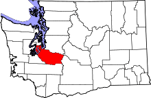 | |
| Towns | ||
| CDPs |
| |
| Other unincorporated communities | ||
| Indian reservation | ||
| Military bases | ||
| Ghost towns | ||
| Footnotes | ‡This populated place also has portions in an adjacent county or counties | |