Giessbachbahn funicular
| Giessbachbahn | |
|---|---|
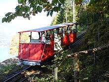
 Looking down the Giessbachbahn, showing car and passing loop | |
| Technical | |
| Track length | 363 metres (1,191 ft) |
| Track gauge | 1,000 mm (3 ft 3 3⁄8 in) |
| Maximum incline | 32% |
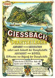
The Giessbachbahn (GbB) is a historic funicular in the Swiss canton of Berne and municipality of Brienz. It links a landing stage on Lake Brienz, served by shipping services on the lake, to the Grand Hotel Giessbach and Giessbach Falls above. The funicular is owned by the hotel, but since 1983 has been operated by a preservation foundation.[1][2][3]
The funicular, opened in 1879, was the first Swiss funicular to be built specifically for the transport of tourists. It has a length of 345 metres (1,132 ft) and overcomes a vertical distance of 104 metres (341 ft) with a maximum gradient of 32%. There are two wooden cars dating from 1879, operating on a single track of 1,000 mm (3 ft 3 3⁄8 in) metre gauge track with a central passing loop and a Riggenbach rack rail for braking purposes. Originally operated by water ballast, the funicular is now electrically operated and a single journey takes 2 minutes.[1]
The line has the following parameters:[4]
| Number of cars | 2 |
| Number of stops | 2 |
| Configuration | Single track with passing loop |
| Track length | 363 metres (1,191 ft) |
| Rise | 98 metres (322 ft) |
| Maximum gradient | 32% |
| Track gauge | 1,000 mm (3 ft 3 3⁄8 in) |
| Speed | 1.9 metres per second (6.2 ft/s) |
| Journey time | 4 mins |
| Capacity | 40 passengers per car; 480 persons in each direction per hour |
See also
References
- 1 2 Green, Richard (February 2007). "Railways in the Berner Oberland - Part 3". Today's Railways Europe. Platform 5 Publishing Ltd (134).
- ↑ map.geo.admin.ch (Map). Swiss Confederation. Retrieved 2012-01-27.
- ↑ "Die Giessbachbahn". Seilbahn-Nostalgie (in German). C. Gentil. Retrieved 2 March 2014.
- ↑ "61.019 Giessbachbahn, Giessbach, Standseilbahn". Swiss Inventory of Ropeways (in German). Swiss Confederation. Retrieved 2010-11-03.
External links
 Media related to Giessbachbahn at Wikimedia Commons
- Giessbach Bahn page from Funimag
- Grand Hotel Giessbach web site
- The Giessbachbahn's entry on the Swiss Inventory of Ropeways
Coordinates: 46°44′06″N 8°01′21″E / 46.7349°N 8.0225°E