Ghantasala, Krishna district
| Ghantasala ఘంటశాల Tankasala | |
|---|---|
| Village | |
 | |
 Ghantasala  Ghantasala Location in Andhra Pradesh, India | |
| Coordinates: 16°9′N 80°16′E / 16.150°N 80.267°ECoordinates: 16°9′N 80°16′E / 16.150°N 80.267°E | |
| Country | India |
| State | Andhra Pradesh |
| District | Krishna |
| Area[1] | |
| • Total | 12.21 km2 (4.71 sq mi) |
| Population (2011)[1] | |
| • Total | 9,248 |
| • Density | 760/km2 (2,000/sq mi) |
| Languages | |
| • Official | Telugu |
| Time zone | IST (UTC+5:30) |
| PIN | 521133 |
| Telephone code | 08671 |
| Vehicle registration | AP 16 |
| Nearest city | Machilipatnam, Gudivada |
| Sex ratio | 10:9.8 ♂/♀ |
| Literacy | 60% |
| Lok Sabha constituency | Machilipatnam |
| Vidhan Sabha constituency | Avanigadda |
Ghantasala is a village in Krishna district of the Indian state of Andhra Pradesh. It is 21 km west of Machilipatnam and 11 km east of river krishna .The largest city of this district, Vijaywada, is around 60 km away. It is a rare and reputed center for Buddhist sculptures.
History
Ghantasala is a town and Mandal Headquarters in Krishna District of Andhra Pradesh. It is 21 km west of Machilipatnam and 11 km east of River Krishna.
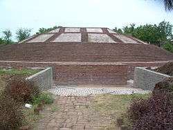
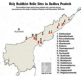
Boswell of the East India Company first reported Ghantasala as a historical site in 1870-71. Alexander Rea excavated the stupa at Ghantasala, which had a circumference of 112 feet and a height of 23 feet. The remains of an important Buddhist stupa and sculptural slabs were found in 1919-20.[2] Ghantasala was once a flourishing town of Indo-Roman trade as well as an important religious centre. The Buddhist relics and the Hindu structures at the place reveal its past glory. Carved limestone columns belonging to pillared halls associated with Buddhist monastic establishments (2-3rd centuries BC ) have been discovered. The ruined Maha Chaitya or stupa that was excavated here is of a unique design. A cube of solid bricks is set in the centre, inscribed with 12 constellations of the zodiac.[3]
The chaityas had a texture and size unique to the Satavahana times and had separate dwelling places for Buddhist monks in the complex. All walls were found to have beautiful plastering with superfine lime mortar. A three-dimensional limestone carved structure, embellished on the dome portion of the stupa had two garland bearers, a dhamma chakra and a miniature stupa on a throne in the middle. Objects such as a four-by-three-feet 'Purna Kalasa' containing lotus flowers, indicating the birth of Gautama Buddha were also discovered. The stupa had concentric inner wheels radiating towards a central chamber.primary amongst them is a raised cylindrical mound with a semi spheric
Economy
Hand-loom industry
Hand loom weaving is most predominant in the village. Mangalagiri and Gadwal cotton sarees are the mostly weaved and are exported many parts of the country.[4]
Transport
Machilipatnam is connected by road and rail from Vijaywada. Vijaywada has an airport located some 20 km away at Gannavaram.
See also
References
- 1 2 "District Census Handbook - Krishna" (PDF). Census of India. p. 16,448. Retrieved 14 February 2016.
- ↑ South Indian Buddhist Antiquities, A. Rea, 1989, Asian Educational Services, ISBN 81-206-0512-8
- ↑ Historical Discoveries in Krishna District of Andhra Pradesh of India
- ↑ Appala Naidu, T (3 April 2013). "Ghantasala weavers now playing major role in weaving exquisite sarees". The Hindu. Ghantasala (Krishna District). Retrieved 17 November 2015.