Gerlachovský štít
| Gerlachovský štít | |
|---|---|
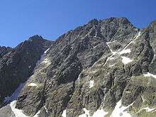
 The south face of Gerlach | |
| Highest point | |
| Elevation | 2,654.4 m (8,709 ft) |
| Prominence | 2,355 m (7,726 ft) [1][2] |
| Isolation | 509 kilometres (316 mi) |
| Listing |
Ultra Country high point |
| Coordinates | 49°10′02″N 20°07′52″E / 49.16722°N 20.13111°ECoordinates: 49°10′02″N 20°07′52″E / 49.16722°N 20.13111°E |
| Naming | |
| Translation | Peak (of the village) of Gerlachov (Slovak) |
| Geography | |
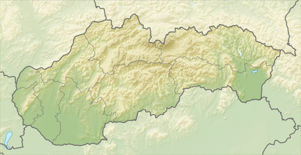 Gerlachovský štít Location in Slovakia | |
| Location | Tatra National Park, Prešov, Slovakia |
| Parent range | High Tatras |
| Geology | |
| Mountain type | granite |
| Climbing | |
| First ascent | 1834 by Ján Still |
| Easiest route | Scramble |

Gerlachovský štít (![]() Slovak pronunciation , translated into English as Gerlach Peak) is the highest peak in the High Tatras, in Slovakia, and in the whole 1,500 km (930 mi) long Carpathian mountain chain, as well as in northern and central Europe (Visegrád Group).
Slovak pronunciation , translated into English as Gerlach Peak) is the highest peak in the High Tatras, in Slovakia, and in the whole 1,500 km (930 mi) long Carpathian mountain chain, as well as in northern and central Europe (Visegrád Group).
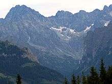
Usually listed at 2,655 metres AMSL (8,711 ft), its exact elevation is actually 0.6 metres (2.0 feet) lower. The pyramidal shape of the massif is marked by a huge cirque. Despite its relatively low elevation, the about 2,000 m vertical rise from the valley floor makes Gerlachovský štít soar.[3] Mistaken for an average mountain in the rugged High Tatras range in the more distant past, it has since played a symbolic role in the eyes of the rulers and populations of several Central European nations, to the point that between the 19th and mid-20th century, it had four different names with six name reversals. It managed to be the highest mountain of the Kingdom of Hungary, and of the countries of Czechoslovakia and Slovakia within the span of only about two decades of the 20th century.
Gerlachovský štít shares its geology and ecology with the rest of the High Tatras, but provides a worthwhile environment for biologists as the highest ground anywhere in Europe north of the parallel linking approximately Munich, Salzburg, and Vienna. With the travel restrictions imposed by the Eastern Bloc, the mountain was particularly treasured as the loftiest point available to climb to by Czechs, East Germans, Hungarians, Poles, and Slovaks. It continues to attract its share of visitors although the local authorities have been continually adding new restrictions on access.
Names
Present
Gerlachovský štít means the "Peak (of the village) of Gerlachov". The Slovak colloquial name is Gerlach. The Polish names are Gerlach or Gierlach, while its Polish colloquial names are Girlach and Garłuch.[4][5][6]
Past
The peak's earliest recorded name was the Szepes-German[7] Kösselberg (Cauldron Mountain) on a map from 1762.[8] The Slovak name of the mountain was first recorded as Kotol, also meaning "Cauldron", in 1821.[9] Both names referred to the peak's characteristic cauldron-like cirque.
The name that became common in travel books and other literature in the 19th century, however, is its current name, linking the mountain to the village of Gerlachov at its foot.[10] It echoed the oldest known undifferentiated reference to the peaks on or near Gerlachov's municipal lands, Gerlachfalvenses montes (Latin with Hungarian elements for the "Gerlachov Village Mountains"), in a drawing of the High Tatras from 1717.[11] It also paralleled the name Gerlsdorfer Spitze (Gerlachov Peak)[12] used by the first person to identify it as the highest peak in the Tatras in 1838 (see below), which was rendered as gerlachovský chochol (Gerlach crest) in a Slovak version of his report in 1851.[13] Several other mountains in the High Tatras have acquired their names from villages in the foothills.
Once it was determined that the mountain was the highest point in the region, the succession of the authorities that held control over it took an interest in its name and changed it periodically for symbolic reasons. In 1896, as part of Austria-Hungary, the highest peak of the Carpathians received its first government-sponsored name − after the contemporary head of state Emperor Francis Joseph I.[14] Guidebooks sometimes did not catch up on these name changes.[15] After the dissolution of the monarchy in 1918, the mountain continued to be known simply as Gerlachovský štít because it belonged to the village of Gerlachov. The Polish government, claiming the territory of the High Tatras for Poland, simultaneously called the mountain Szczyt Polski (Polish Peak), but never gained control over it.[14] The new Czechoslovak government changed the name to Štít legionárov (Legionnaires Peak) in honor of the Czechoslovak Legions in 1923, but the name was dropped in favor of the earlier Gerlachovský štít in 1932.[16] As a result of the Communist coup d'état in 1948, the mountain was renamed once more − to Stalinov štít (Stalin Peak) in 1949.[6] Its traditional name Gerlachovský štít was restored yet again a decade later and has remained unchanged through the present.
History

Gerlachovský štít was not always considered the highest mountain in the Tatras. After the first official measurement of peaks in the Tatras during the period of the Habsburg Monarchy in the 18th century, Kriváň (2,494 m) was considered the highest. Other candidate peaks for the status of the highest mountain at that time were Lomnický štít (2,633 m) and Ľadový štít (2,627 m). The first person to accurately name Gerlachovský štít as the highest peak was the forester Ľudovít (Ludwig) Greiner in 1838.[12][17][18] Greiner's measurement was formally confirmed by an Austrian Army survey party in 1868. However, it was generally accepted only after the Vienna Military Institute for Geography issued a new, authoritative collection of maps of Central Europe in ca. 1875.[19][20]
The first confirmed ascent was made by Ján (Johann) Still from the village of Nová Lesná in 1834.[21] In 1880, the routes through the Velická próba (Velická Challenge) and Batizovská próba (Batizovská Challenge) were secured by chains.
Access
Only members of a national UIAA club are allowed to climb the peak on their own. Other visitors have to take a certified mountain guide. The two easiest routes, usually up the Velická próba and down the Batizovská próba named after their respective valleys, are protected by chains. Because of an exposed section along the Velická próba and tricky orientation especially on the ridge, both are among the more difficult scrambling routes in the High Tatras, although it's rather climbing, since there are many moments when one must rely on ones hands to hold ones bodyweight.[22] With no snow, guidebooks grade the routes as a II or III climb (UIAA scale)[3] or lower.[23] The total elevation gain is about 1,000 m (3,300 ft) for those who spend the night at the Sliezsky Dom Hotel[24] or are driven there by a mountain guide, and about 1,665 m (5,463 ft) for those who hike from Tatranská Polianka. In winter, Gerlachovský štít offers a challenging alpine climb, with mixed climbing and a risk of avalanches.[3]
The unmarked trailhead is on the green-marked trail leading up Velická Valley near the southern edge of the first plateau (Kvetnica) above the Sliezsky Dom. The equally unmarked, indistinct route to Gerlach veers off north-west towards the mountain's eastern slopes at the elevation of ca. 1,815 m (5,955 ft), but occasional cairns begin to appear farther on. The fastest and easiest descent is down the Batizovská próba.[22] Mountain guides always follow the route in the east-west direction, ascending from Velická Valley and descending into Batizovská Valley, in order to reduce logjams.
Two most popular multi-pitch routes for technical climbing are on the eastern and south-western walls.[22] Both are exceptionally long and situated on solid granite walls. The best season for climbing is mid September to mid October or until the snow falls.[3] Another good season lasts from late June to early August.
The route to Gerlachovský štít falls under the Tatra National Park ordinance, according to which hikers who depart from marked trails may be subject to fines unless they are UIAA members, or are led by an IFMGA-certified mountain guide. Camping is subject to similar restrictions. Rangers and some mountain guides are authorized to collect fines on the spot. Cairns that hikers build to mark the trailhead are periodically taken apart.
Conditions at the summit
Human response
Although authors estimate that at least some of the manifestations of altitude sickness may appear at elevations as low as 1,500–2,400 m (4,900–7,900 ft)[25] it has not been reported in the Tatras. Low air pressure begins to have marginal but detectable effects at the summit (2,654.4 m; 8,709 ft). Water boils at about 91.5 °C (196.7 °F)[26] and arterial oxygen saturation is about 8% lower than at most visitors' places of residence,[27] but it is difficult to distinguish slight oxygen deprivation at the summit from fatigue caused by the exertion required to reach it. Authors speak of possible minimal sensory impairment above 1,500 m (4,900 ft). Unlike fitness, age in itself is not a determinant factor in reaching the highest point in the Tatras. The famed Tatra guide Ján Počúvaj took clients to the summit of Gerlach until the age of 76.[28]
View
Like a 19th-century comment in a British guidebook, "impressive and picturesque",[29] modern hikers usually appreciate the panoramic view of the highest and many other peaks in the High Tatras, from Kriváň in the west to Široká in the north and Lomnický štít in the east. Farther on, but often visible, are the eastern Low Tatras in the south and part of the Belianske Tatras in the east. Better than usual visibility, a rare occurrence except in the fall and winter, is needed to see the Stolické vrchy, Volovské vrchy, the Slovak Paradise region, and Branisko. Quite exceptionally, visibility may extend to the Austrian Alps and the Polish–Czech Giant Mountains hundreds of miles away.[30]
Hikers' reported enjoyment of the view is at least partly attributable to their awareness that they are at the highest point in all of northern and central Europe (Visegrád countries). Visibility is merely 10 km (6.2 mi) or less on most summer afternoons because of the amount of water vapor in the air or because of cloudiness (fog). Days with afternoon visibility of 50 km (31 mi) or more are common only later in the fall and in winter.[31] The view is partly blocked by the long ridge of Končistá in the west, areas near the mountain towards the south and north are obscured by the Gerlach massif itself. Several other summits in the High Tatras, including some with marked trails, offer more spectacular views with precipitous drops, varied scenery, and encompassing vistas.[32]
Weather
The effects of high-altitude weather on those who ascend Gerlachovský štít may be more pronounced than its altitude alone. The temperature gradient between the Tatra mountain resorts (900–1,350 m or 2,950–4,430 ft) and the summit can be steep.[33] Low air temperature higher up can be masked by high insolation under clear skies, but will take its effect with increased cloud cover.[34] Combined with windy conditions, the impact may be considerably detrimental even without rain or snow. The summit disappears in the clouds for periods of time on most days,[35] which translates to fog at that elevation and possible disorientation[36] as well as anxiety.
While temperatures are somewhat lower on Gerlachovský štít because of its elevation, the weather and its potential impact on visitors is little different from other summits in the High Tatras both with and without marked trails. The typical daily weather pattern in the summer is a clear morning, clouds gathering by mid-morning—noon, occasional showers and storms in the afternoon. The chance of rain is lowest between 9–10 am and peaks between 2–3 pm, with a drop-off after 6 pm. The frequency of storms with lightning (as opposed to rainstorms) on Gerlach's summit and on the other highest ridges is little different from lower elevations,[37] too, but people exposed to wind, (sometimes freezing) rain, and lightning have greater difficulty to cope. The nearest shelter for those who ascend Gerlach is the Sliezsky Dom Hotel, there are no natural shelters along the route.
Climate
| Jan | Feb | Mar | Apr | May | Jun | Jul | Aug | Sep | Oct | Nov | Dec | |
|---|---|---|---|---|---|---|---|---|---|---|---|---|
| Air temperature 2–3 pm, Celsius |
-11 | -11 | -8 | -5 | 0 | 3 | 5 | 5 | 2 | -1 | -6 | -9 |
| Air temperature 2–3 pm, Fahrenheit |
12 | 12 | 17 | 23 | 32 | 37 | 41 | 41 | 36 | 10 | 21 | 16 |
| Precipitation in millimeters |
120 | 120 | 100 | 130 | 120 | 190 | 190 | 140 | 90 | 90 | 130 | 150 |
| Days with storms and lightning | 0 | 0 | 0 | 2 | 5 | 9 | 9 | 6 | 2 | 0 | 0 | 0 |
| Days with summit 10+ min. in clouds (low visibility) |
21 | 20 | 22 | 23 | 26 | 25 | 26 | 24 | 21 | 19 | 21 | 21 |
| Days with rime ice | 19 | 15 | 16 | 16 | 13 | 5 | 4 | 5 | 10 | 11 | 17 | 19 |
| Days with snowfall[39] | 19 | 16 | 18 | 19 | 16 | 9 | 5 | 4 | 6 | 11 | 17 | 19 |
| Days with snow cover >1 cm (0.4 in) |
31 | 28 | 31 | 30 | 24 | 8 | 4 | 3 | 6 | 15 | 28 | 31 |
| Days with visibility >20 km (12.4 mi) at 2–3 pm |
15 | 12 | 12 | 7 | 3 | 3 | 4 | 5 | 8 | 17 | 15 | 15 |
See also
References
- ↑ "Europe Ultra-Prominences". Peaklist.org. Retrieved 7 January 2015.
- ↑ "Gerlachovský štít, Slovakia". Peakbagger.com. Retrieved 7 January 2015.
- 1 2 3 4 "Gerlachovsky Stit". SummitPost.org. 27 December 2005. Retrieved 3 June 2007.
- ↑ "Anna Kłosińska, Słownik ortograficzny," (in Polish). 2004. Retrieved 15 November 2007.
- ↑ "GERLACH". Encyklopedia Internautica (in Polish). n.d. Retrieved 15 November 2007.
- 1 2 Ivan Bohuš, Od A po Z o názvoch Vysokých Tatier, 1996.
- ↑ Milan Olejník (2002). ""Impact of external factors upon the formation of ethnicity – the case of German community living in the region of Zips (Slovak Republic)." Človek a spoločnosť". Slovak Academy of Sciences in Košice. Retrieved 16 November 2007.
- ↑ Illegible in this image. – Francis Florian Czaki, Mappa geographica repræsentans partem Hungariæ nempe sic dictum Comitatum de Zips ... Comitat Scepusiensis. Engraved by Friedrich Hampe, 1762. In: Józef Szlafarski, Poznanie Tatr, 1972.
- ↑ Jakob Meltzer, "Das Zipser Comitat." In: Johannes Csaplovics, Topographisch-statistisches Archiv des Königreiches Ungarn, 1821.
- ↑ For instance: Alexander F. Heksch, Führer durch die Karpathen und oberungarischen Badeorte. 1881.
- ↑ Georg Buchholtz Jr., Delineatio Nomenclatura Montium Carpathicorum, qualiter sese Lomnitzæ conspiciendi sistunt. 1717. In: Ivan Houdek, Osudy Vysokých Tatier. 1951.
- 1 2 Ludwig Greiner, "Die Gerlsdorfer Spitze als die höchste Gebirgshöhe der Karpathen." Gemeinnützige Blaetter zur Belehrung und Unterhaltung, 1839.
- ↑ L. Greiner, "Gerlachovský chochol, jako nejvyšší jehlan v Tatrách." Slovenské noviny, November 1851.
- 1 2 "Gerlachovský štít" (in Slovak). Mikuláš Argalács and Dominik Michalík. 2003. Retrieved 3 June 2007.
- ↑ For instance: Karel Drož, Tatry. 1897.
- ↑ "Baron Adrien de Gerlache: Víte co má nejslavnější belgický polárník společného s nejvyšší horou Vysokých Tater?" (in Czech). Foreign Ministry of the Czech Republic. 2005. Retrieved 16 November 2007.
- ↑ źudovít Greiner
- ↑ Pamätná izba Ľudovíta Greinera v Revúcej
- ↑ Július Burkovský and Igor Viszlai (6 October 2006). "Ľudovít Greiner" (in Slovak). Lesy SR (Forests of the Slovak Republic). Retrieved 3 June 2007.
- ↑ Contrary to its title, it actually contained 14 plates: Josef Schlacher, General-Karte von Mittel-Europa. In 12 Blättern. ca. 1875.
- ↑ Ján (Johann) Still | Nová Lesná
- 1 2 3 "Menu on the left – Gerlachovský štít" (in Slovak). tatry.nfo.sk. n.d. Retrieved 3 June 2007.
- ↑ Július Andráši and Arno Andráši, Tatranské vrcholy: Vysokohorský sprievodca. 1973.
- ↑ "Mountain Hotel Sliezsky Dom". travelslovakia.sk. Retrieved 10 November 2010.
- ↑ Geoff Brundrett, "Sickness at high altitude: a literature review." Journal of the Royal Society of Health, 2002.
- ↑ O. Peter Snyder Jr. (2002). "Boiling point / Atmospheric pressure / Altitude tables.". Hospitality Institute of Technology and Management St. Paul, Minnesota, USA. Retrieved 20 November 2007.
- ↑ Charles Houston, High Altitude: Illness and Wellness. 1993.
- ↑ Václav Cibula, "Šestsetkrát na vrcholu." Krásy domova, 1963.
- ↑ Karl Baedeker, Austria, Including Hungary, Transylvania, Dalmatia, and Bosnia. 1900.
- ↑ For instance: (eb), "Babie leto je slávnejšie ako Medard." Korzár, 21 September 2002.
- ↑ Jadwiga Orliczowa and Vladimír Peterka, "Dohľadnosť." In: Mikuláš Konček, et al. Klíma Tatier. 1974.
- ↑ Vladimír Adamec, Slovensko: 69 vyhliadkových vrcholov. 1981.
- ↑ Miluláš Konček and Michał Orlicz, "Teplotné pomery." In: Mikuláš Konček, et al. Klíma Tatier. 1974.
- ↑ František Smolen and Mieczysław Kołodziejek, "Žiarenie." In: Mikuláš Konček, et al. Klíma Tatier. 1974.
- ↑ Jadwiga Orliczowa and Vladimír Peterka, "Oblačnosť a slnečný svit." In: Mikuláš Konček, et al. Klíma Tatier. 1974.
- ↑ Stanislav Samuhel, "Je výstup na Gerlach nebezpečný?" Krásy Slovenska, 1966.
- ↑ Kazimierz Chomicz and Ferdinand Šamaj, "Zrážkové pomery." In: Mikuláš Konček, et al. Klíma Tatier. 1974.
- ↑ The weather and climate data for this altitude are rounded from averages of varying numbers of decades through the 1960s. They may represent or diverge from current averages or averages covering longer periods: Mikuláš Konček, et al. Klíma Tatier. 1974.
- ↑ Vojtech Briedoň, Kazimierz Chomicz and Mikuláš Konček, "Snehové pomery." In: Mikuláš Konček, et al. Klíma Tatier. 1974.
External links
| Wikimedia Commons has media related to Gerlachovsky stit. |
- "Gerlachovsky Stit". SummitPost.org.
- QTVR 360 degree panorama from the peak
- Detailed descriptions of peaks in the High Tatras (Slovak)
- Map of the area